1943 Chapin Pictorial Map of the Pacific Fortified Positions During World War II
ArteriesPacific-chapin-1943$400.00

Title
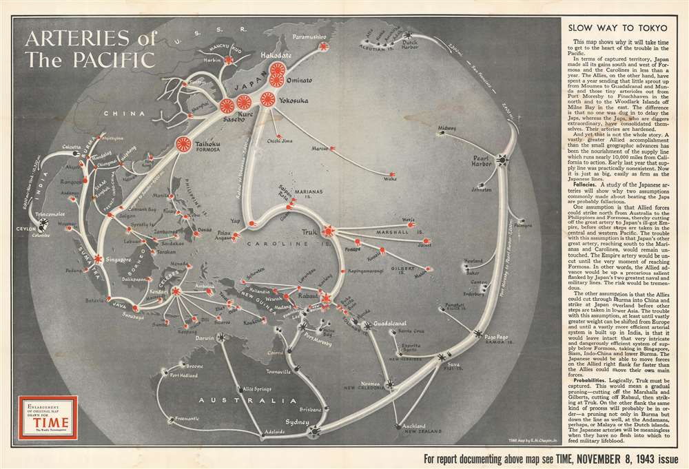
Arteries of the Pacific.
1943 (dated) 29.5 x 43.5 in (74.93 x 110.49 cm)
1943 (dated) 29.5 x 43.5 in (74.93 x 110.49 cm)
Description
This is an enlarged, separate issue version of a 1943 Robert M. Chapin, Jr. pictorial map of the Pacific Ocean fortifications and supply routes at the height of the Pacific War during World War II. Wonderfully compiled, the map depicts the region from India to Hawaii and from Kamchatka and the Aleutian Islands to Australia and New Zealand. Concise and clear iconography is used to delineate both American and Japanese fortifications and supply lines, allowing viewers to easily comprehend the strategic reality of the Pacific War. Icons in the shape of shore guns mark the fortified locations of both Japan and the United States, with white 'arteries' connecting them all. Moreover, a very frank text along the right border explains in no uncertain terms why the Pacific campaign has been so much more difficult for the Americans than it was for the Japanese in late 1941 and the first half of 1942. One of the many important factors in the relating to the American advance pointed out the reality of a 10,000-mile supply line between where combat was taking place and the California coast. The establishment and protection of this 'artery' was essential. Another such factor was that the Japanese had the advantage of attacking unfortified positions, while the Americans, in order to roll back Japan's conquests, had to land troops on beachheads on heavily fortified islands.
Publication History and Census
This map was created by Robert M. Chapin, Jr. and published by TIME Magazine in 1943. The OCLC records examples of this map in the collections of Yale University, Franklin and Marshall College, and Wichita State University. We are also aware of an example in the collection of the Hoover Institution.Cartographer
Robert M. Chapin Jr. (fl. 1933 - 1970) was a prominent architect, cartographer and illustrator active during World War II and the Cold War. Chapin graduated from the University of Pennsylvania in 1933 with a degree in architecture. Since this was the height of the Great Depression, and architects in low demand, he instead took work as a staff cartographer at Newsweek. Catching the attention of Manfred Gottfried of Time, Chapin was offered an accepted a position at the head of Time's cartography department. He remained with Time for some 33 years, from 1937 to 1970, often drawn 2 - 3 new thematic maps weekly. With an architect's gift visualizing information, Chapin became a skilled informational cartographer, heading the cartography department at Time Magazine. Chapin, like Fortune Magazine chief cartographer, Richard Edes Harrison, Chapin was at the forefront of infographic propaganda cartography, a genre that matured during the World War II Era and remains popular today. Working for Time Magazine, Chapin developed a signature style for his long run of 'War Maps.' Chapin was known for his maverick airbrush technique which lead to strong color splashes and intense shading. He also incorporated celluloid stencils to illustrate bomb explosions, flags, sinking ships, and more - generating a instantly recognizable standardized style. Chapin's Time war maps were further distinctive for their use of strong bold reds as a universal symbol of hostility. Chapin graduated from the University of Pennsylvania in 1933 with a degree in architecture. Since this was the height of the Great Depression, an d architects in low demand, he instead took work as a staff cartographer at Newsweek. Catching the attention of Manfred Gottfried of Time, Chapin was offered an accepted a position at the head of Time's cartography department. He remained with Time for some 33 years, from 1937 to 1970, often drawn 2 - 3 new thematic maps weekly. Chapin live in Sharon Connecticut. More by this mapmaker...
Condition
Average. Heavy soiling. Verso repairs to fold separations. Exhibits loss at fold intersections. Blank on verso.
References
OCLC 47735135.