This item has been sold, but you can get on the Waitlist to be notified if another example becomes available, or purchase a digital scan.
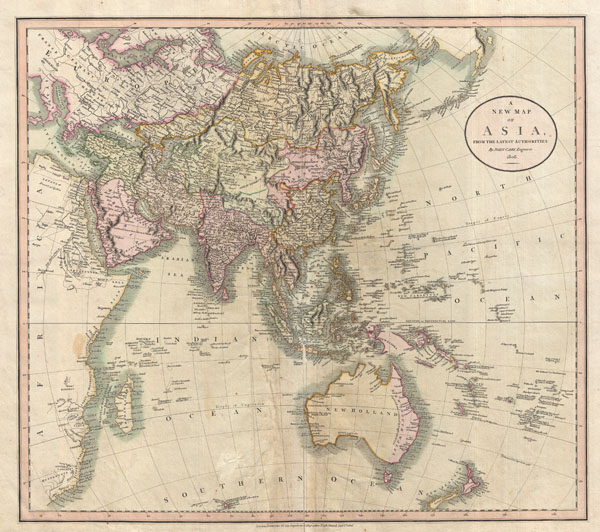
1806 Cary Map of Asia, Polynesia, and Australia
Asia-cary-1806$137.50

Title
A New Map of Asia, From the Latest Authorities.
1806 (dated) 18.5 x 21 in (46.99 x 53.34 cm)
1806 (dated) 18.5 x 21 in (46.99 x 53.34 cm)
Description
This is John Cary's stunning 1806 map of Asia, Australia, and Polynesia. Covers from the Mediterranean to the Aleutian Islands and from the Arctic to South Africa, Australia, and New Zealand. This beautifully rendered map is truly a masterpiece of engraving, with mountain ranges, lakes, deserts, and rivers excited with such precision that the result appears almost three dimensional. Cary injects astounding detail throughout with countless towns, cities, geographical features, rivers, islands and bodies of water noted. In desert regions fresh water sources are noted. In the seas certain shoals and undersea are included. In China and Manchuria the Great Wall appears. Singapore islands is shown but not specifically named. The Liakhov Islands, in northern Siberia, which some believed to be entirely composed of fossil mammoth ivory, are noted as 'Shore Discovered by Hunters.' Published by John Cary in his 1808 Cary's New Universal Atlas.
Cartographer
John Cary (1754 - 1835) was a London based cartographer active in the early part of the 19th century. Ronald Vere Tooley, the prominent English map historian, writes of Cary, "As an engraver he was elegant and exact with fine clear lettering and great delicacy of touch." Cary began his work as an engraver, cartographer, and globe maker in 1776 with his New and Correct English Atlas. This important atlas represented a new phase in cartography where accuracy and detail rose in prominence over the decorative embellishments of the 18th century. This change was indicative of the times when travel and commerce were expanding globally as never before. Cary's mastery of both engraving and cartography resulted in a series of seminal works that redefined mapmaking in the early 19th century. His stupendous Cary's New Universal Atlas, published in 1808, set the standard for all cartographers who followed. Cary reissued this seminal atlas in 1811, 1819, 1824, 1828, 1833, 1836 and 1844. Cary also did considerable work on the English Ordinance Survey prior to 1805. His cartographic work particularly inspired the Edinburgh school of cartography as represented by John Pinkerton and John Thomson. In America, Cary's work was used as the basis for Tanner's important New American Atlas. Cary's last published atlas appeared posthumously in 1844, however, by 1850 Cary's work was being carried on by his sons and other well-known cartographers including James Wyld, John Tallis & Company, and Crutchley. More by this mapmaker...
Source
Cary, John, Cary's New Universal Atlas, containing distinct maps of all the principal states and kingdoms throughout the World. From the latest and best authorities extant. London: Printed for J. Cary, Engraver and Map-seller, No. 181, near Norfolk Street, Strand, 1808.
Condition
Good. Some creasing and repairs near original centerfold. Minor soiling here and there. Original plate mark visible. Blank on verso.
References
Rumsey 1657.042. Phillips (Atlases) 714. Fordham, J.C., John Cary, p. 77-82.