This item has been sold, but you can get on the Waitlist to be notified if another example becomes available, or purchase a digital scan.
1783 Janvier Map of Asia
Asia-janvier-1783$220.00

Title
L'Asie divisee en ses Principaux Etats.
1783 (undated) 12.5 x 17.5 in (31.75 x 44.45 cm) 1 : 35000000
1783 (undated) 12.5 x 17.5 in (31.75 x 44.45 cm) 1 : 35000000
Description
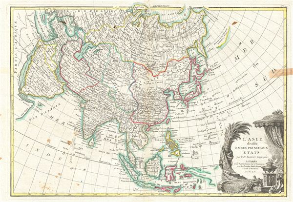
A beautiful example of Le Sieur Janvier's 1783 map of Asia. Covers from Africa and the Mediterranean east to Bering Strait (Detroit du Norte ou d'Anian) and south as far as Java and New Guinea. This map is most interesting in its rendering of the largely unexplored extreme northwest of Asia. Yeco or Hokkaido is mapped only speculatively with its western borders unknown. Shows Sakhalin Island in an embryonic state.
Just to the east of Yeco (Hokkaido), Janvier maps the apocryphal Terre de Gama or Terre de la Company. Often called de Gamma Land or Gama, these islands were supposedly discovered in the 17th century by a mysterious figure known as Jean de Gama. Various subsequent navigators claim to have seen this land, but it was left to Bering to finally debunk the myth. In 1729, he sailed for three days looking for Juan de Gama land but never found it. Though it may be little more than a mis-mapping of Hokkaido or the Japanese Kuriles, Gama or Compagnie remained on maps for about 50 years following Bering's voyages until the explorations of Cook confirmed the Bering findings.
Though the mainland of Siberia and northeast Asia are remarkably well mapped based upon the explorations of Vitus Bering and Tschirikow, a further anomaly appears in the form of an unusual landmass just to the east of Kamchatka roughly where the Aleutian Islands are today. A note reads that this land mass claims that it was seen in 1741, suggesting either Vitus Bering or Alexei Chirikov. This is most likely an embryonic representation of the Muller Peninsula. The Muller Peninsula was a postulated by Gerhard Muller around this time based on recorded sightings of the Aleutian Archipelago and their misinterpretation of it as a single land mass.
Further to the south New Guinea (Novelle Guinee) is maps speculatively with most of its eastern and southern borders left either blank or hidden behind the grand title cartouche.
A decorative title cartouche displaying the riches of the continent appears in the lower right hand quadrant. A fine map of the region. Drawn by J. Janvier in 1783 for issue as plate no. 24 in Jean Lattre's 1783 final issue of the Atlas Moderne.
CartographerS
Jean Denis Janvier (fl. 1746 - 1776), sometime also known as 'Robert', was a Paris based cartographer active in the mid to late 18th century. Janvier signed his maps Signor Janvier. By the late 18th century, Janvier was awarded the title of 'Geographe Avec Privilege du Roi' and this designation appears on many of his later maps. Janvier worked with many of the most prominent French, English and Italian map publishers of his day, including Longchamps, Faden, Lattre, Bonne, Santini, Zannoni, Delamarche, and Desnos. More by this mapmaker...
Jean Lattré (170x - 178x) was a Paris based bookseller, engraver, globe maker, calligrapher, and map publisher active in the mid to late 18th century. Lattré published a large corpus of maps, globes, and atlases in conjunction with a number of other important French cartographic figures, including Janvier, Zannoni, Bonne and Delamarche. He is also known to have worked with other European cartographers such as William Faden of London and the Italian cartographer Santini. Map piracy and copyright violations were common in 18th century France. Paris court records indicate that Lattré brought charges against several other period map publishers, including fellow Frenchman Desnos and the Italian map engraver Zannoni, both of whom he accused of copying his work. Lattré likes trained his wife Madame Lattré (né Vérard), as an engraver, as a late 18th century trade card promotes the world of 'Lattré et son Epouse.' Lattré's offices and bookshop were located at 20 rue St. Jaques, Paris, France. Later in life he relocated to Bordeaux. Learn More...
Source
Lattre, Jean, Atlas Moderne ou Collection de Cartes sur Toutes les Parties du Globe Terrestre, c. 1783.
Condition
Very good condition. Original centerfold. Discoloration extending from left margin as far as the 'D' in 'SUD'. Blank on verso. Occasional foxing.
References
Rumsey 2612.048. Phillips (Atlases) 664. National Maritime Museum, 215.