This item has been sold, but you can get on the Waitlist to be notified if another example becomes available, or purchase a digital scan.
1866 Mitchell Map of Asia
Asia-mitchell-1866$50.00

Title
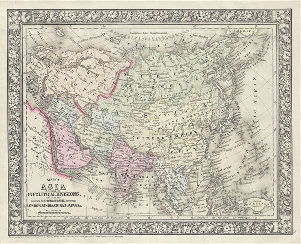
Map of Asia Showing its Gt. Political Divisions, and, also, the various Routes of Travel, between London and India, China and Japan etc.
1860 (dated) 11.5 x 14 in (29.21 x 35.56 cm) 1 : 43500000
1860 (dated) 11.5 x 14 in (29.21 x 35.56 cm) 1 : 43500000
Description
This is a beautiful example of the legendary American map publisher Samuel Augustus Mitchell Jr.'s 1866 map of Asia. This map covers from the Arabian Peninsula and Turkey eastward as far as Kamchatka, Japan, the Philippines and New Guinea. It includes the Empires of Hindoostan (India), China (includes Tibet), Toorkistan, Persia (Iran), Cabool, Beloochistan (Afghanistan), Birma (Burma), Siam (Thailand), Anam (Vietnam), Malaysia, Japan, etc. Also included are adjacent portions of Africa, Europe and Polynesia. The map makes note of the steamship routes and mileages from London to various destinations in Asia. Tibet, Korea and Ladak are included within the borders of the Chinese Empire. Identifies both the Grand Canal and the Great Wall in China. The disputed body of water between Korea and Japan is here identified as the Japan Sea. Taiwan or Formosa is mapped vaguely, representing the poor knowledge of the region prior to the Japanese invasion and subsequent survey work in 1895. Afghanistan is divided into Cabool and the southern province of Beloochistan (Baluchistan).
As this map was drawn, Imperial China wilted under the weak Qing Dynasty while the Russian Empire attained the height of its pan-continental expansion. Turkey and the Middle East were under Ottoman rule while the British Raj governed of India.
This map also identifies various cities, towns, rivers and an assortment of additional topographical details. Map is color coded according to political boundaries with elevation rendered by hachure. The whole is surrounded by the attractive floral border common to Mitchell atlases between 1860 and 1866. One of the most attractive American atlas maps of this region to appear in the mid-19th century.
Prepared by S. A. Mitchell Jr. for inclusion as plate 77 in the 1866 issue of Mitchell's New General Atlas. Like many American map publishers of this period, Mitchell did not regularly update his copyright, consequently this map is dated and copyrighted to 1860: 'Entered according to Act of Congress in the Year 1860 by S. Augustus Mitchell Jr. in the Clerks Office of the District Court of the U.S. for the Eastern District of Pennsylvania.'
Cartographer
Samuel Augustus Mitchell (March 20, 1792 - December 20, 1868) began his map publishing career in the early 1830s. Mitchell was born in Bristol, Connecticut. He relocated to Philadelphia in 1821. Having worked as a school teacher and a geographical writer, Mitchell was frustrated with the low quality and inaccuracy of school texts of the period. His first maps were an attempt to rectify this problem. In the next 20 years Mitchell would become the most prominent American map publisher of the mid-19th century. Mitchell worked with prominent engravers J. H. Young, H. S. Tanner, and H. N. Burroughs before attaining the full copyright on his maps in 1847. In 1849 Mitchell either partnered with or sold his plates to Thomas, Cowperthwait and Company who continued to publish the Mitchell's Universal Atlas. By about 1856 most of the Mitchell plates and copyrights were acquired by Charles Desilver who continued to publish the maps, many with modified borders and color schemes, until Mitchell's son, Samuel Augustus Mitchell Junior, entered the picture. In 1859, S.A. Mitchell Jr. purchased most of the plates back from Desilver and introduced his own floral motif border. From 1860 on, he published his own editions of the New General Atlas. The younger Mitchell became as prominent as his father, publishing maps and atlases until 1887, when most of the copyrights were again sold and the Mitchell firm closed its doors for the final time. More by this mapmaker...
Source
Mitchell Jr., S. A., Mitchell's New General Atlas, Containing Maps Of The Various Countries Of The World, Plans Of Cities, Etc. Embraced In Forty-Seven Quarto Maps, Forming A Series Of Seventy-Six Maps And Plans, Together With Valuable Statistical Tables, 1866 edition.
Condition
Very good. Minor spotting.
References
Rumsey 0565.039 (1860 edition). Phillips (Atlases) 831. New York Public Library, Map Division, 1510834.