This item has been sold, but you can get on the Waitlist to be notified if another example becomes available, or purchase a digital scan.
1892 Rand McNally Map of Asia
Asia-randmcnally-1895$37.50

Title
Map of Asia.
1892 (dated) 20 x 27 in (50.8 x 68.58 cm) 1 : 19008000
1892 (dated) 20 x 27 in (50.8 x 68.58 cm) 1 : 19008000
Description
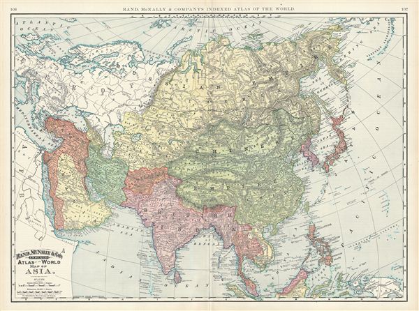
This is a beautiful example of Rand McNally and Company's 1892 map of Asia. It covers from the Arctic Ocean south as far as Sumatra and from the Arabian Peninsula and Turkey eastward as far as Kamchatka, Japan, the Philippines and New Guinea. It includes the empires of Hindoostan (India), China (includes Tibet), Toorkistan, Persia (Iran), Cabool, Beloochistan (Afghanistan), Birma (Burma / Myanmar), Siam (Thailand), Anam (Vietnam), Malaysia, Japan, etc. Tibet is included within the borders of the Chinese empire. The Great Wall and the Imperial Canal are both identified. The disputed body of water between Korea and Japan is here identified as the Japan Sea. The map notes the route of the Trans-Siberian railroad.
As this map was being drawn, Imperial China wilted under the weak Qing Dynasty while the Russian empire attained the height of its pan-continental expansion. It was at the time, under the more peaceful rule of Alexander III, who, after the assassination of his father, the more liberal, Tzar Alexander II, took over the reign of the empire. Japan was witnessing a transformation of its feudalistic society into a modernized nation but would soon engage in the First Sino-Japanese War for control over Korea and Taiwan. Meanwhile, Turkey and the Middle east were under declining Ottoman rule while the British Raj governed of India.
Color coded according to countries and territories, the map notes several towns, cities, rivers, mountains, and various other topographical details with relief shown by hachure. This map was issued as plate nos. 106 and 107 in the 1895 issue of Rand McNally and Company's Indexed Atlas of the World - possibly the finest atlas Rand McNally ever issued.
Cartographer
Rand, McNally and Co. (fl. 1856 - present) is an American publisher of maps, atlases and globes. The company was founded in 1856 when William H. Rand, a native of Quincy, Massachusetts, opened a print shop in Chicago. Rand hired the recent Irish immigrant Andrew McNally to assist in the shop giving him a wage of 9 USD per week. The duo landed several important contracts, including the Tribune's (later renamed the Chicago Tribune) printing operation. In 1872, Rand McNally produced its first map, a railroad guide, using a new cost effective printing technique known as wax process engraving. As Chicago developed as a railway hub, the Rand firm, now incorporated as Rand McNally, began producing a wide array of railroad maps and guides. Over time, the firm expanded into atlases, globes, educational material, and general literature. By embracing the wax engraving process, Rand McNally was able to dominate the map and atlas market, pushing more traditional American lithographic publishers like Colton, Johnson, and Mitchell out of business. Eventually Rand McNally opened an annex office in New York City headed by Caleb S. Hammond, whose name is today synonymous with maps and atlases, and who later started his own map company, C. S. Hammond & Co. Both firms remain in business. More by this mapmaker...
Source
Rand McNally & Co., Foreign Countries. Rand, McNally & Co's Indexed Atlas of the World (Complete in Two Volumes)…, (Chicago) 1895.
Condition
Very good. Minor wear along original centerfold. Text on verso.
References
Rumsey 3565.028 (1897 edition). Philip (atlases) 1026 (1898 edition).