This item has been sold, but you can get on the Waitlist to be notified if another example becomes available, or purchase a digital scan.
1823 Manuscript Map of Asia
Asia-wyld-1823$250.00

Title
Asia.
1823 (undated) 15 x 18 in (38.1 x 45.72 cm)
1823 (undated) 15 x 18 in (38.1 x 45.72 cm)
Description
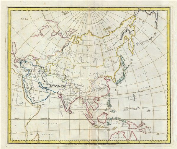
An unusual and beautiful semi-manuscript map of the Asia dating to 1823. The printed portions of this map follow the cartography of James Wyld and include the basic outlines of the countries, latitude and longitude lines, the Arctic circle, the Tropic of Cancer, and the equator. The remainder of the map, including all textual labels and color work, had been completed in manuscript, that is to say, hand drawn. Wyld most likely produced this map intentionally without labels for use as a classroom workbook by which children could learn geography by filling in the blanks.
The manuscript geographical data and detail throughout is altogether outstanding. The work is completed in a fine hand adept at decorative text and the rendering of rivers and mountains. The geography follows the conventions of the period. The Great Wall of China is identified, as are several mountain ranges (including the Himalayas) and rivers. The sea between Japan and Korea, whose name is disputed between the two countries, is here identified as the 'Sea of Corea or Japan.' The northern part of Australia is shown and is named New Holland. The northern portions of Asia including most of Russia and China are relatively unmapped. The New Siberian and Liakhov Islands, believed at the time to be composed entirely of fossilized mammoth ivory, are here noted as 'Land seen by the Russians.'
An altogether unique and wonderful one of a kind find.
Cartographer
Wyld (1823 - 1893) was a British publishing firm active throughout the 19th century. It was operated by James Wyld I (1790 - 1836) and his son James Wyld II (November 20, 1812 - 1887) were the principles of an English mapmaking dynasty active in London during much of the 19th century. The elder Wyld was a map publisher under William Faden (1749 - 1836) and did considerable work on the Ordinance Survey. On Faden's retirement in 1823, Wyld took over Faden's workshop, acquiring many of his plates. Wyld's work can often be distinguished from his son's maps through his imprint, which he signed as 'Successor to Faden'. Following in his father's footsteps, the younger Wyld joined the Royal Geographical Society in 1830 at the tender age of 18. When his father died in 1836, James Wyld II was prepared to fully take over and expand his father's considerable cartographic enterprise. Like his father and Faden, Wyld II held the title of official Geographer to the Crown, in this case, Queen Victoria. In 1852, he moved operations from William Faden's old office at Charing Cross East (1837 - 1852) to a new, larger space at 475 Strand. Wyld II also chose to remove Faden's name from all of his updated map plates. Wyld II continued to update and republish both his father's work and the work of William Faden well into the late 1880s. One of Wyld's most eccentric and notable achievements is his 1851 construction of a globe 19 meters (60 feet) in diameter in the heart of Leicester Square, London. In the 1840s, Wyld also embarked upon a political career, being elected to parliament in 1847 and again in 1857. He died in 1887 following a prolific and distinguished career. After Wyld II's death, the family business was briefly taken over by James John Cooper Wyld (1844 - 1907), his son, who ran it from 1887 to 1893 before selling the business to Edward Stanford. All three Wylds are notable for producing, in addition to their atlas maps, short-run maps expounding upon important historical events - illustrating history as it was happening - among them are maps related to the California Gold Rush, the New South Wales Gold Rush, the Scramble for Africa, the Oregon Question, and more. More by this mapmaker...
Condition
Very Good. Partial manuscript. Original centerfold. Platemark visible. Wide margins.