This item has been sold, but you can get on the Waitlist to be notified if another example becomes available, or purchase a digital scan.
1855 Perthes Map of Asia at the end of the 18th Century
Asia18th-perthes-1855$50.00

Title
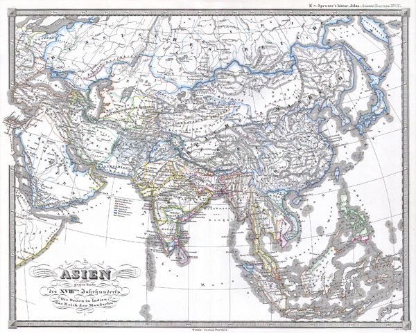
Asien gegen ende des 18th Jahrhunderts. Die Briten in Indien; das Reich der Mandschu.
1855 14 x 17 in (35.56 x 43.18 cm)
1855 14 x 17 in (35.56 x 43.18 cm)
Description
This fascinating hand colored map depicts Asia at the end of the 18th century. The British had established themselves in India and the Chinese Empire was under Manchu control. Also depicts Southeast Asia in good detail with early versions of Vietnam (Anam & Tonkin), Cambodia (Kambodscha) and Thailand. Singapore is labeled Published as part of Karl von Spruner's Historical Atlas of 1855.
Cartographer
Johan Georg Justus Perthes (September 11, 1749 - May 2, 1816) was one of the most important German cartographic engravers of the 19th century. He was born in the Thuringian town of Rudolstadt, the son of a court physician. In 1778, he began working as a bookseller in Gotha. Perthes began his publishing empire shortly thereafter with the 1784 issue of the famed survey of European nobility known as the Almanac de Gotha. In the next year, 1785, he founded the cartographic firm of Justus Perthes Geographische Anstalt Gotha. His son Wilhelm Perthes (1793 - 1853) joined the firm in 1814. Wilhelm had prior publishing experience at the firm of Justus Perthes' nephew, Friedrich Christoph Perthes, who ran a publishing house in Hamburg. After Justus Perthes died in 1816, Wilhelm took charge and laid the groundwork for the firm to become a cartographic publishing titan. From 1817 to 1890. the Perthes firm issued thousands of maps and more than 20 different atlases. Along with the visionary editors Hermann Berghaus (1797 - 1884), Adolph Stieler (1775 - 1836), and Karl Spruner (1803 - 1892), the Perthes firm pioneered the Hand Atlas. When Wilhelm retired, management of the firm passed to his son, Bernhardt Wilhelm Perthes (1821 – 1857). Bernhardt brought on the cartographic geniuses August Heinrich Peterman (1822 - 1878) and Bruno Hassenstein (1839 - 1902). The firm was subsequently passed to a fourth generation in the form of Berhanrd Perthes (1858 – 1919), Bernhard Wilhelm's son. The firm continued in the family until 1953 when, being in East Germany, it was nationalized and run as a state-owned enterprise as VEB Hermann Haack Geographisch-Kartographische Anstalt Gotha. The Justus family, led by Joachim Justus Perthes and his son Wolf-Jürgen Perthes, relocated to Darmstadt where they founded the Justus Perthes Geographische Verlagsanstalt Darmstadt. More by this mapmaker...
Condition
Fine or perfect condition. Margins wide. Blank on verso.