This item has been sold, but you can get on the Waitlist to be notified if another example becomes available, or purchase a digital scan.
1712 Wells Map of Asia Minor, Israel, Palestine, Syria, Jordan and Iraq
AsiaMinor-wells-1712$175.00

Title
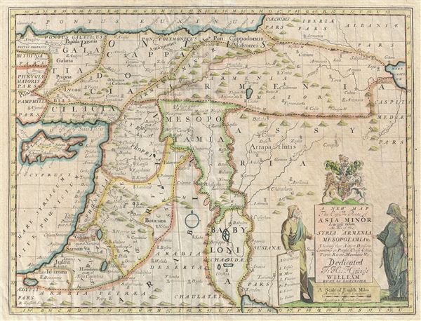
A New Map of the Eastern Parts of Asia Minor Largely taken: As Also of Syria, Armenia, Mesopotamia and c. Showing their Antient Divisions, Countries or People, Chiefe Cities, Towns, Rivers, Mountains, and c. Dedicated to His Highness William Duke of Gloucester.
1712 (undated) 15 x 20 in (38.1 x 50.8 cm)
1712 (undated) 15 x 20 in (38.1 x 50.8 cm)
Description
An unusual 1712 map of the Middle East in antiquity by Edward Wells of Oxford. Covers from the Black Sea to the Persian Gulf and from Cyprus to the Caspian Sea. Includes the modern day countries of Cyprus, Turkey, Syria, Lebanon, Israel, Palestine, Jordan, and Iraq. A decorative title cartouche appears in the lower right quadrant. This like many other Wells maps, is dedicated to Prince William, Duke of Gloucester and son of Queen Anne, who, when this map was being prepared, was a student at Oxford. Engraved by R. Spofforth and published by T. Bonwicke for the 1712 edition of Edward Wells' Atlas, A New Sett of Maps both of Ancient and Present Geography.
Cartographer
Edward Wells (1667 - 1727) was an English mathematician, geographer, and classical scholar based at Christ Church College, Oxford. Wells trained for the ministry but quickly found himself unsuited to religious life and instead applied for an academic position at Oxford, where he authored numerous well respected works on a wide range of mathematical and scientific topics. He tutored Prince William, the sickly son of Queen Anne, who was likely about 11 at the time this map was prepared. Wells dedicated nearly all of the maps in his atlas, A New Sett of Maps both of Ancient and Present Geography, to the young prince - quite possibly posthumously, as William died in July of 1700 shortly prior to the publication of the atlas. Nonetheless, Wells' geography proved popular and was published in number editions well into the 1730s. More by this mapmaker...
Source
Wells, E., A New Sett of Maps both of Ancient and Present Geography, (London, T. w. Bonwicke) c. 1712.
Condition
Good condition. Some warping of the paper. Original centerfold. Some creasing to left of centerfold. Original pressmark visible. Blank on verso. Even overall toning.
References
Laor, E., Map of the Holy Land: Cartobibliography of Printed Maps, 1475 - 1900, no. 833.