1712 Wells Map of Asia Minor, Israel, Palestine, Syria, Jordan and Iraq
asiaminorsyria-wells-1700$400.00

Title
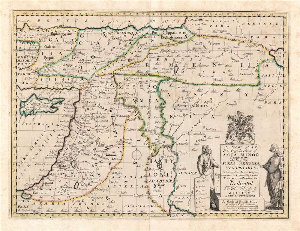
A New Map of the Eastern Parts of Asia Minor Largely taken: As Also of Syria, Armenia, Mesopotamia and c. Shewing their Antient Divisions, Countries or People, Chiefe Cities, Towns, Rivers, Mountains etc. Dedicated to His Highness William Duke of Gloucester.
1700 (undated) 14.5 x 19.25 in (36.83 x 48.895 cm) 1 : 3970000
1700 (undated) 14.5 x 19.25 in (36.83 x 48.895 cm) 1 : 3970000
Description
This is an elegant 1700 Edward Wells map of the eastern Mediterranean and ancient Mesopotamia. Coverage extends from Cyprus and Asia Minor, eastwards as far as the Caspian and Persian Gulf. The central focus is the watershed of the Tigris and Euphrates, thus embracing ancient Mesopotamia and Babylonia. The kingdoms of Assyria, Armenia, Palestine and Syria are prominent. A decorative title cartouche appears in the lower right, surmounted by the arms of the dedicatee - Prince William, Duke of Gloucester and the son of Queen Anne, who, when this map was being prepared, was a student of Wells. The sickly William never lived to see his tutor's work completed.
Publication History and Census
This map was engraved by Robert Spofforth for inclusion in Edward Wells' 1700 work, A New Sett of Maps Both of Ancient and Present Geography. This atlas was successful, and stayed in publication for many years thereafter - outliving Wells considerably.CartographerS
Edward Wells (1667 - 1727) was an English mathematician, geographer, and classical scholar based at Christ Church College, Oxford. Wells trained for the ministry but quickly found himself unsuited to religious life and instead applied for an academic position at Oxford, where he authored numerous well respected works on a wide range of mathematical and scientific topics. He tutored Prince William, the sickly son of Queen Anne, who was likely about 11 at the time this map was prepared. Wells dedicated nearly all of the maps in his atlas, A New Sett of Maps both of Ancient and Present Geography, to the young prince - quite possibly posthumously, as William died in July of 1700 shortly prior to the publication of the atlas. Nonetheless, Wells' geography proved popular and was published in number editions well into the 1730s. More by this mapmaker...
Robert Spofforth (fl. 1700 - 1707) was an English engraver and printseller known primarily for his frontispieces. He contributed nine engravings to Edward Wells’ A New Sett of Maps both of Ancient and Present Geography, including the frontispiece of the atlas. He was thought to have been a student of the engraver Simon Gribelin. He was also known for his portraits, namely those of Queen Anne and Prince George. Learn More...
Source
Wells, E., A New Sett of Maps both of Ancient and Present Geography, (London, T. W. Bonwicke) c. 1700.
Condition
Very good. Some wear along original centerfold. Old reinforcement to bottom centerfold, and few marginal mends well away from printed image. Original outline color.
References
OCLC 1118077161. Rumsey 11181.035. Laor, E., Map of the Holy Land: Cartobibliography of Printed Maps, 1475 - 1900, #833.