This item has been sold, but you can get on the Waitlist to be notified if another example becomes available, or purchase a digital scan.
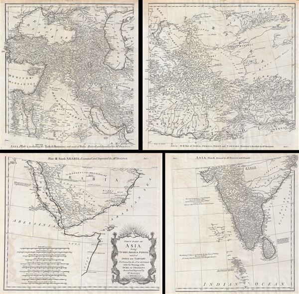
1755 Postlethwayte Four Part Map of Turkey, Arabia, Persia, India and Tartary
AsiaWest-postlethwayte-1755$500.00

Title
First Part of Asia, being Turkey, Arabia, Persia, most of India and Tartary.
1755 (dated) 32 x 34 in (81.28 x 86.36 cm)
1755 (dated) 32 x 34 in (81.28 x 86.36 cm)
Description
A curious and uncommon four panel wall map 1786 map of India, Persia, and Arabia by the english publisher M. Postlethwayte. Published in four separate panels, this map can be either joined as a single massive map as assembled, as above, in separate panels. As a whole the map centers on Persia, covering from Istanbul to eastern India and Tibet, and from the Black Sea to the Maldives. Postlethwayte derived this map from the influential French cartographer J. B. B. d'Anville's similar map of 1751, which here has been re-engraved, updated, and translated into english by S. Bolton. If offers excellent coverage of the central Asian portions of the Silk Route naming the centers of Samarkand, Bukhara, Lop Nor, and others. At the bottom center there is a decorative title cartouche of a rococo ethic.
As this map was being edited, the eastern portions including Turkey, Arabia, and most of the modern day Middle east, were under the waning hegemony of the Ottoman empire. In Arabia, the first 'Saudi State' had already been established in 1744 and, though owing nominal allegiance to Istanbul, dominated much of the central Arabian Peninsula. The presumably more valuable costal lands and river valleys of Mesopotamia (modern day Iraq) remained under direct Ottoman suzerainty.
Persia at this time was itself experiencing the early years of the short lived Zand Dyansty who ruled from the capital city of Isfahan – identified here. The Zand ruled Persia for roughly 50 years until, in 1794, Aga Muhammad Khan overthrew Loft Ali Khan, last Shah of the Zand Dynasty, and relocated the capital to the new city of Terhan. The subsequent era, the Qajar Dynasty, witnessed numerous military conflicts, the rising powers of Imperial Russia, and the loss of much of Persia's territory.
India meanwhile was quickly falling under the control of the British east India Company who, from a few coastal outposts, were rapidly asserting their authority over most of the subcontinent. One year after the issue of the issue of this map the outbreak of the Seven Years War largely ended France's colonial ambitions, leaving only indigenous nations to stand against British imperial ambitions. eventually only Sultanate of Mysore, under Tipu Sultan, remained independent. By 1799 Tipu Sultan had been defeated and all of India fell under the at least nominal control of the British east India Company.
This map was prepared by Samuel Bolton and engraved by R. W. Seale for issue in Postlethwayte's 1755 edition of the Dictionary of Commerce. Plate 1 measures 16 inches high and 14.5 inches wide. Plate 2 measures 16 high and 16.5 inches wide. Plate 3 measures 15 inches high and 17.25 inches wide. Plate 4 measures 15 inches high and 13.5 inches wide.
CartographerS
Malachy Postlethwayt (c. 1707 - 1767) was a British economist and commercial expert famous for his publication of the commercial dictionary titled The Universal Dictionary of Trade and Commerce in 1751. The dictionary was a translation and adaptation of the Dictionnaire économique of the French Inspector General of the Manufactures for the King, Jacques Savary des Brûlons. Malachy claims to have spent nearly 20 years adapting and researching his important dictionary, which attained a popular following. The second edition of the Dictionary issued in 1752, was updated with a series of fine maps based upon D'Anville's work, but updated by Postlethwayt to reflect his political and social views. Politically Postlethwayt was extremely conservative and highly patriotic though his views more often than not took the form of rants against the social and political enemies of the British Empire. In the mid-1740s Postlethwayt lobbied for the Royal Africa Company and was known for his pro-slavery advocacy. His belief that the slave trade had a place in the larger "political arithmetic" of empire, promoted through his many popular books and other publications, in time became the party line for the ruling class. Despite his misguided feelings about the Africa slave trade, Postlethwayt was an influential and thoughtful economist whose ideas influenced Adam Smith, Samuel von Pufendorf, Alexander Hamilton, and others. Postlethwayt also commonly spelled his name as Postlethawyte and Postlethwait. More by this mapmaker...
Solomon Boulton (fl. c. 1750-1775), sometimes written as 'Bolton,' was an English cartographer active in the middle part of the 18th century. Bolton's most notable works are the adaptions of Jean Baptiste Bourguignon d'Anville (1697 - 1782) maps published in conjunction with Malachy Postlethwayte's Dictionary of Commerce. These were later reprinted and embellished by Sayer and Bennett, and again by Laurie and Whittle. Learn More...
Jean Baptiste Bourguignon d'Anville (1697 - 1782) was perhaps the most important and prolific cartographer of the 18th century. D'Anville's passion for cartography manifested during his school years when he amused himself by composing maps for Latin texts. There is a preserved manuscript dating to 1712, Graecia Vetus, which may be his earliest surviving map - he was only 15 when he drew it. He would retain an interest in the cartography of antiquity throughout his long career and published numerous atlases to focusing on the ancient world. At twenty-two D'Anville, sponsored by the Duke of Orleans, was appointed Geographer to the King of France. As both a cartographer and a geographer, he instituted a reform in the general practice of cartography. Unlike most period cartographers, D'Anville did not rely exclusively on earlier maps to inform his work, rather he based his maps on intense study and research. His maps were thus the most accurate and comprehensive of his period - truly the first modern maps. Thomas Basset and Philip Porter write: "It was because of D'Anville's resolve to depict only those features which could be proven to be true that his maps are often said to represent a scientific reformation in cartography." (The Journal of African History, Vol. 32, No. 3 (1991), pp. 367-413). In 1754, when D'Anville turned 57 and had reached the height of his career, he was elected to the Academie des Inscriptions. Later, at 76, following the death of Philippe Buache, D'Anville was appointed to both of the coveted positions Buache held: Premier Geographe du Roi, and Adjoint-Geographer of the Academie des Sciences. During his long career D'Anville published some 211 maps as well as 78 treatises on geography. D'Anville's vast reference library, consisting of over 9000 volumes, was acquired by the French government in 1779 and became the basis of the Depot Geographique - though D'Anville retained physical possession his death in 1782. Remarkably almost all of D'Anville's maps were produced by his own hand. His published maps, most of which were engraved by Guillaume de la Haye, are known to be near exact reproductions of D'Anville' manuscripts. The borders as well as the decorative cartouche work present on many of his maps were produced by his brother Hubert-Francois Bourguignon Gravelot. The work of D'Anville thus marked a transitional point in the history of cartography and opened the way to the maps of English cartographers Cary, Thomson and Pinkerton in the early 19th century. Learn More...
Source
Postlethwayte, M., Mr. Postlethwayt's Universal Dictionary of Commerce, Vol. II, (London), 1755.
Condition
Very good. We are most likely the first to have unfolded these rare maps. Original fold lines visible. Blank on verso. Paper shows slight warping. Set of four maps. Minor offsetting. Size given is for full map, if joined. Presents well framed tightly or professionally joined into a single map.