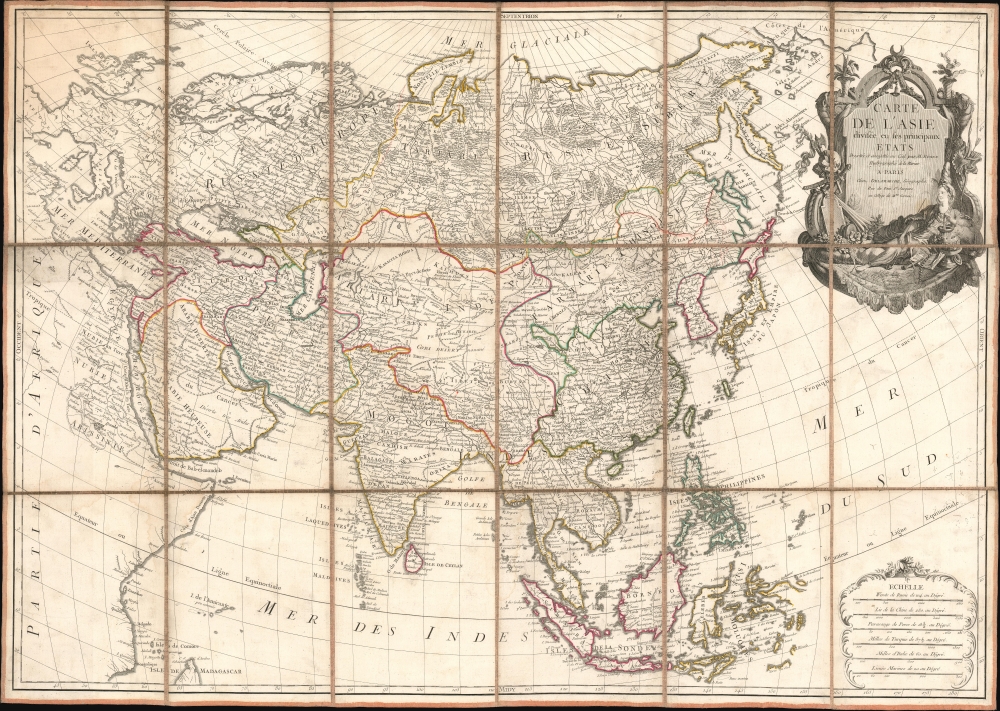
1779 Bonne / Delamarche Separate-Issue Map of Asia
Asie-delamarche-1779$2,250.00

Title
Carte de L'Asie divisée en ses principaux Etats.
1779 (undated) 29.5 x 42 in (74.93 x 106.68 cm) 1 : 14500000
1779 (undated) 29.5 x 42 in (74.93 x 106.68 cm) 1 : 14500000
Description
An exceptional large-format separate-issue c. 1779 map of Asia issued by Rigobert Bonne and Charles-François Delamarche. The map is a compilation of the best cartographic information regarding Asia available at the time of publication.
A Closer Look
Coverage embraces from the Mediterranean to the Bering Strait, and from the Arctic Ocean to Java and Timor. Much of the source cartography can be traced to the work of J. B. B. D'Anville - note the distinctive square shape of Korea - but Bonne's considerable revision has brought it current to about 1779. Particularly striking is the large ornamental title cartouche in the upper right, illustrating the wealth, indolence, and decadence stereotypically attributed to Asia by orientalists of the late 18th century.The Bering Strait
There is a manuscript note identifying the Bering Strait (Detroit de Behring) and Cape Est, suggesting interest in the region by an early owner. Further south, the Aleutian Islands (as well as the Isle St. Andre) are named but placed haphazardly, indicative of a pre-Cook analysis. Some of the islands here are recognizable, particularly S. Diomede, today's Diomede Islands, named by Vitus Bering in 1728.Publication History and Census
The cartography is attributed to Rigobert Bonne. The present example was published by Charles-François Delamarche. The Boston Public Library owns an edition published by Jean Lattré, dated 1779. It is hard to know which came first, or if they were published simultaneously, as the map appeared during an overlap in their careers. Both examples exhibit signs of re-engraving in the title cartouche, so an earlier, now lost, precursor may exist. The map is scarce. Aside from the Lattré variant at the Boston Public Library, additional examples 'might' be held at Cornell and at the British Library - unfortunately, they are not imaged and the common-place title was widely used by the same cartographers for lesser atlas maps.CartographerS
Rigobert Bonne (October 6, 1727 - September 2, 1794) was one of the most important French cartographers of the late 18th century. Bonne was born in Ardennes à Raucourt, France. He taught himself mathematics and by eighteen was a working engineer. During the War of the Austrian Succession (1740 - 1748) he served as a military engineer at Berg-op-Zoom. It the subsequent years Bonne became one of the most respected masters of mathematics, physics, and geography in Paris. In 1773, Bonne succeeded Jacques-Nicolas Bellin as Royal Cartographer to France in the office of the Hydrographer at the Depôt de la Marine. Working in his official capacity, Bonne compiled some of the most detailed and accurate maps of the period - most on an equal-area projection known erroneously as the 'Bonne Projection.' Bonne's work represents an important step in the evolution of the cartographic ideology away from the decorative work of the 17th and early 18th century towards a more scientific and practical aesthetic. While mostly focusing on coastal regions, the work of Bonne is highly regarded for its detail, historical importance, and overall aesthetic appeal. Bonne died of edema in 1794, but his son Charles-Marie Rigobert Bonne continued to publish his work well after his death. More by this mapmaker...
Charles-François Delamarche (August 1740 - October 31, 1817) founded the important and prolific Paris-based Maison Delamarche map publishing firm in the late 18th century. A lawyer by trade, Delamarche entered the map business with the 1787 acquisition from Jean-Baptiste Fortin of Robert de Vaugondy's map plates and copyrights. Delamarche appears to have been of dubious moral character. In 1795, the widow of Didier Robert de Vaugondy, Marie Louise Rosalie Dangy, petitioned a public committee for 1500 livres, which should have been awarded to her deceased husband. However, Delamarche, proclaiming himself Vaugondy's heir, filed a simultaneous petition and walked away with the funds, most of which he was instructed to distribute to Robert de Vaugondy's widow and children. Just a few months later, however, Delamarche proclaimed Marie Dangy deceased, and it is highly unlikely that any funds found their way to Robert de Vaugondy's impoverished daughters. Nonetheless, where Robert de Vaugondy could barely make ends meet as a geographer, Delamarche prospered as a map publisher, acquiring most of the work of earlier generation cartographers Lattre, Bonne, Desnos, and Janvier, thus expanding significantly upon the Robert de Vaugondy stock. Charles Delamarche eventually passed control of the firm to his son Felix Delamarche (c. 1750 - c. 1850) and geographer Charles Dien (1809 - 1870). It was later passed on to Alexandre Delamarche, who revised and reissued several Delamarche publications in the mid-19th century. The firm continued to publish maps and globes until the middle part of the 19th century. Learn More...
Condition
Very good. Minor water toning here and there. Original linen backing stable.
References
Boston Public Library, Leventhal Center, G1015 .A85 1783.