This item has been sold, but you can get on the Waitlist to be notified if another example becomes available, or purchase a digital scan.
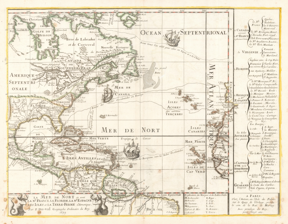
1679 Pierre DuVal Map of North America, the Caribbean and the Atlantic
Atlantic-duval-1679$2,250.00

Title
La Mer De Nort où sont la Nle. France, La Floride, La Nle. Espagne, Les Isles et La Terre-Ferme d'Amerique, Par P. Du-val Geographe Ordinaire du Roy 1679.
1679 (dated) 16 x 20.75 in (40.64 x 52.705 cm) 1 : 24000000
1679 (dated) 16 x 20.75 in (40.64 x 52.705 cm) 1 : 24000000
Description
This is the rare, first state of Pierre DuVal's 1679 map of eastern North America, the Caribbean, and the Atlantic Ocean. DuVal's map significantly updates the earlier efforts of Nicolas Sanson, his uncle and teacher, and includes notations reflective of a new wave of exploration. Its eastern limits include the Atlantic coast of the Iberian Peninsula, the Azores, the Canary Islands and the Cap Verde Islands, and the coast of Africa from Morocco to the Guinea coast.
Further south, the routes of ships sailing to and from Europe and the West Indies are delineated - with two different tracks indicated for the return to Europe. One of these passes between Florida and the Bahamas; another, passing between Cuba and Hispaniola, is labeled in French 'the Ancient route of the return of the Spanish.'
Updated Nomenclature
While DuVal's topography relies solidly on his uncle's work - for example witness the Sanson delineation of the Great Lakes - DuVal has taken pains to update the placenames to reflect current information. The map's right border features a text panel outlining the provinces and major cities of the countries included on the sheet from Canada down to Guyana, including New England and New York (interestingly, categorized as belonging to 'Canada, autrement Nle. France,' a snub also reflected in the coloration of the map if not the engraved boundary. This, too, has been updated. Whereas Sanson's maps refer to 'Nouveau Pays Bas,' DuVal has corrected this to 'New York'. New Sweden is still noted, although that colony had been conquered by the Dutch in 1655. In Acadia, Port Royal is included. This reflects the return of the town to France from Great Britain according to the 1667 Treaty of Breda. In New England, Boston is named. An attempted 1665 Northwest Passage is labeled (see below).A Navigable Atlantic
DuVal's map includes three sailing tracks across the Atlantic - overall, simply emphasizing the navigability of that body of water connecting Europe with America. The tracks are embellished with ships sailing in the appropriate directions. The northernmost track, passing through the Davis and the Hudson Straits and on to Hudson's and Buttons Bay, is labeled in French 'The route taken in 1665 to go to Japan and China.' This is probably a reference to the attempted Northwest Passage of Pierre-Esprit Radisson (1636/1640 - 1710). The 1665 voyage of this fur trader, adventurer, missionary, and explorer represented his third attempt to find a passage to the Pacific, this time sponsored by the English King Charles II. It achieved neither Japan nor China, but his efforts did lead to a 1670 royal charter granting exclusive rights to the land surrounding Hudson Bay, ultimately fostering the founding the Hudson's Bay Company.Further south, the routes of ships sailing to and from Europe and the West Indies are delineated - with two different tracks indicated for the return to Europe. One of these passes between Florida and the Bahamas; another, passing between Cuba and Hispaniola, is labeled in French 'the Ancient route of the return of the Spanish.'
Separate Map or Part of Wall Map?
This was among the new maps engraved in Paris by Jean Baptiste Liebaux for inclusion with DuVal's Cartes Géographiques. It also was issued separately as part of DuVal's four-sheet map of the Western Hemisphere. The presence of a centerfold and a manuscript page number added to the verso indicates that this was either an example intended for the atlas or was included in a contemporary composite atlas. While DuVal did include this as the second part of his four-sheet map of the western hemisphere, his inclusion of individual titles and imprints on each sheet allowed him great flexibility in how this map could be sold or presented. They were sometimes offered separately as individual sheets and were also included in DuVal's atlas as well as being joinable as a wall map.Publication History and Census
The present example is the 1679 first state, with DuVal's address in the imprint. A posthumous 1688 second state, with the imprint of DuVal's daughter and heir, is also recorded. The separate map is rare both on the market and in institutional collections, with only four copies so listed. OCLC lists the four-sheet map only at the University of Bern and the Clements. DuVal's atlas is also quite rare: we see only seven examples in institutional collections. We have seen this separate map in no auction records or dealers' catalogs, and we have not seen any other examples on the market.CartographerS
Pierre Du Val (May 19, 1619 - September 29, 1683) was a French cartographer and publisher active in Paris during the middle part of the 17th century. He was born Abbeville, Picardie, France, where his father, also Pierre, was a merchant, consul, and alderman. His mother was Marie Sanson, sister of Nicolas Sanson d'Abbeville (1600-1667), the leading French cartographer of his day. Du Val and probably apprenticed in Sanson's workshops. Afterwards, in Paris, he studied geography under Jean-Baptiste Gault, who later became the Bishop of Marseilles. He counseled M. Henri of Savoye, abbot of St. Sorlin, and M. Gilles Bouraut, bishop of Aire and later Evreux, in matters of science and geography. Du Val became Geographe ordinaire to Louis XIV in 1650. His first atlas, the 1654 Cartes Geographiques Methodiquement Divisees, contained few of his own maps and was mostly compiled from reissues of maps by other cartographers. His early work focused on atlases and geographical treatises, but later, he turned his attentions to large separate issue, often multi-sheet maps. After his death in 1683, his widow, Marie Desmaretz, continued his business at least until 1684, after which it passed to his daughters (either Marie-Angelique or Michelle), who published until at least 1688. He is the elder brother of Placide de Sainte Hélène (1648 - 1734), Placidium Augustinum, an Augustine monk and geographer. More by this mapmaker...
Nicolas Sanson (December 20, 1600 - July 7, 1667) and his descendants were the most influential French cartographers of the 17th century and laid the groundwork for the Golden Age of French Cartography. Sanson was born in Picardy, but his family was of Scottish Descent. He studied with the Jesuit Fathers at Amiens. Sanson started his career as a historian where, it is said, he turned to cartography as a way to illustrate his historical studies. In the course of his research some of his fine maps came to the attention of King Louis XIII who, admiring the quality of his work, appointed Sanson Geographe Ordinaire du Roi. Sanson's duties in this coveted position included advising the king on matters of geography and compiling the royal cartographic archive. In 1644, he partnered with Pierre Mariette, an established print dealer and engraver, whose business savvy and ready capital enabled Sanson to publish an enormous quantity of maps. Sanson's corpus of some three hundred maps initiated the golden age of French mapmaking and he is considered the 'Father of French Cartography.' His work is distinguished as being the first of the 'Positivist Cartographers,' a primarily French school of cartography that valued scientific observation over historical cartographic conventions. The practice result of the is less embellishment of geographical imagery, as was common in the Dutch Golden Age maps of the 16th century, in favor of conventionalized cartographic representational modes. Sanson is most admired for his construction of the magnificent atlas Cartes Generales de Toutes les Parties du Monde. Sanson's maps of North America, Amerique Septentrionale (1650), Le Nouveau Mexique et La Floride (1656), and La Canada ou Nouvelle France (1656) are exceptionally notable for their important contributions to the cartographic perceptions of the New World. Both maps utilize the discoveries of important French missionaries and are among the first published maps to show the Great Lakes in recognizable form. Sanson was also an active proponent of the insular California theory, wherein it was speculated that California was an island rather than a peninsula. After his death, Sanson's maps were frequently republished, without updates, by his sons, Guillaume (1633 - 1703) and Adrien Sanson (1639 - 1718). Even so, Sanson's true cartographic legacy as a 'positivist geographer' was carried on by others, including Alexis-Hubert Jaillot, Guillaume De L'Isle, Gilles Robert de Vaugondy, and Pierre Duval. Learn More...
Source
DuVal, P., Cartes Géographiques, (Paris: DuVal) 1679.
Condition
Very good. Old ink stains to lower corners, few within printed image. Bottom centerfold mended well outside printed image. Else excellent with original outline color and generous margins.
References
OCLC 953693390. Burden, P., The Mapping of America: A List of Printed Maps, 1151-1670, 508.