This item has been sold, but you can get on the Waitlist to be notified if another example becomes available, or purchase a digital scan.
1728 Cutler Chart of Chesapeake Bay and Maritime Canada
Atlantick-senex-1728$1,400.00

Title
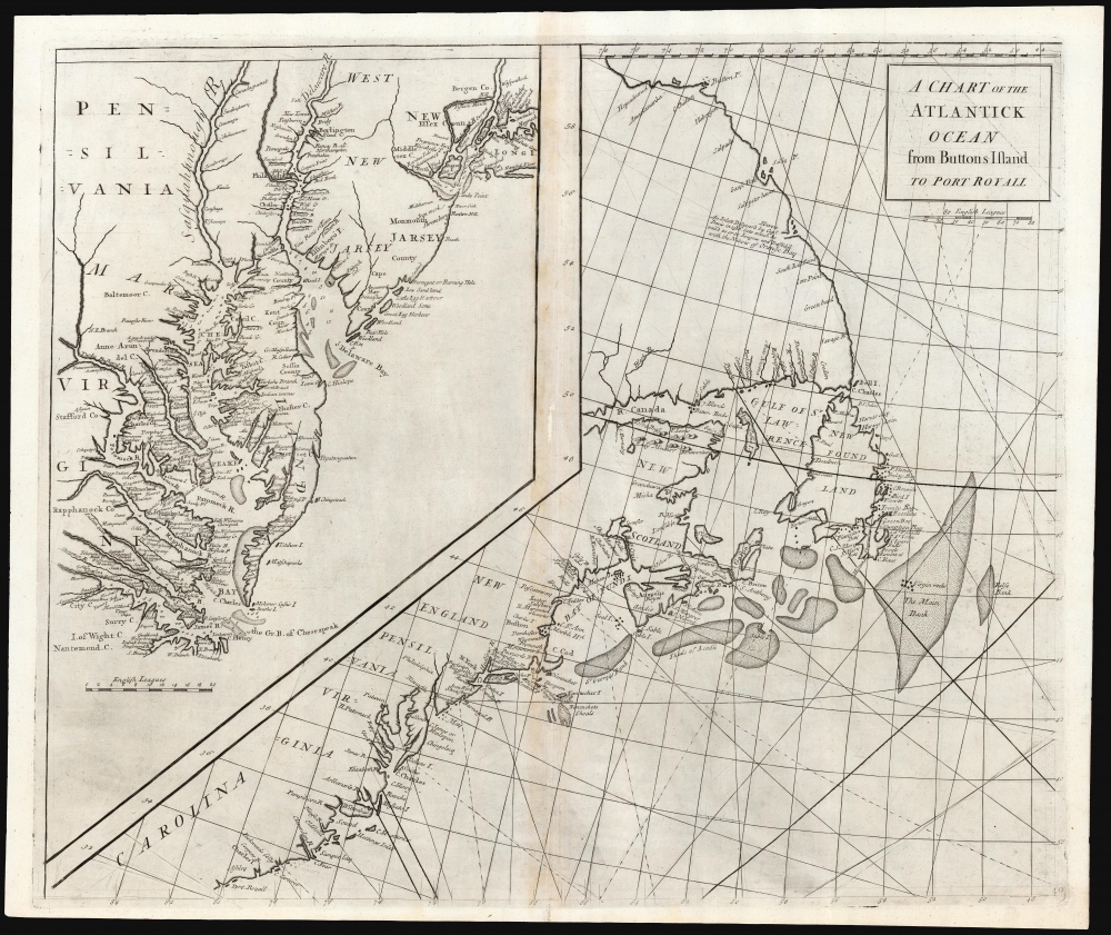
A Chart of the Atlantick Ocean from Buttons Island to Port Royall.
1728 (undated) 19.5 x 22.75 in (49.53 x 57.785 cm) 1 : 6400000
1728 (undated) 19.5 x 22.75 in (49.53 x 57.785 cm) 1 : 6400000
Description
This is a scarce, elegant 1728 Senex chart of the east coast of North America, from Port Royal in South Carolina to Button Island in Arctic Canada. It includes an inset chart richly detailing Chesapeake and Delaware Bays, and New York Harbor.
The Atlas maritimus et commercialis was, as suggested by its title, intended to be commercial in focus: as such, its charts very often highlighted fishing grounds, as does this one. The Grand Banks of Newfoundland are indicated prominently, with stippling. Near the middle of the main bank marked with crosses are the Virgin Rocks - while these are now known mainly as a navigational hazard, from as far back as the sixteenth century they were renowned as one of the best cod fisheries in the Banks.
The inset chart provides the strongest connection to Senex on this work. It is closely derived from the 1685 Morden 'A New Map of New England, New York, New Jarsey, Pensilvania, Maryland and Virginia'. John Senex had reissued the Morden himself in 1719, so its appearance here is a convincing signal of his authorship. The distinctive 'Fisher's Reach' appearing in Essex and Bergen counties New Jersey is almost identical, and the patterns of shallows and inlets in Delaware and Chesapeake Bays (notably the curvilinear shallow on the right bank of the opening of Chesapeake Bay) are a closer match to the Morden than any other likely precursor map - probably the 1698 issue, whose 'Che Sea Peake' spelling of the Chesapeake this chart reproduces. The absence of firm borders between Pennsylvania, New Jersey, and Maryland is reflective of this early source. This map makes no comment on the border disputes that would characterize this region in later years.
The Mapmaker
The actual authorship of this chart, and the rest of those in the Atlas maritimus et commercialis, is obscure in the literature. The editor of the navigational instructions, Nathaniel Cutler, is commonly credited with the charts - Wooldridge, for instance, credits this map to Cutler, as does Kershaw. Nothing, however, is known about Cutler's background and history and beyond the Atlas' general coasting pilot there is no other known work attributed to him. McCorkle tentatively attributes the work to John Senex, and there is enough of the map's content that appears to be drawn from contemporaneous work of Senex to support the notion. Since that mapmaker is known to have contributed to the Atlas maritimus overall, it is reasonable to conclude that Senex was responsible for this chart. The illustrious Edmond Halley is sometimes hopefully offered as an author, but he is unlikely to have contributed more than his approval of the novel projection utilized in the atlas, itself devised by Cutler.The Primary Chart
The chart's scope is broad, reaching from the northern extremes of Labrador down to the South Carolina coastline. The northern parts of Labrador were still, in the early 18th century, among the remotest parts of the world for European geographers, and that coastline is both scant in detail and highly speculative. An inlet appears, between 56º and 58º north, labeled 'An Inlet Discover'd by Capt. Davis in 1586 into which he sail'd 20 or 30 Leagues and Traffick'd with the Natives of Orange Bay'; it is phrased closely to a note in the same place on Senex's 1710 map of North America. (A similar note does appear on De l'Isle's 1703 map of Canada, and this may have influenced its inclusion on Senex's 1710 map.)The Atlas maritimus et commercialis was, as suggested by its title, intended to be commercial in focus: as such, its charts very often highlighted fishing grounds, as does this one. The Grand Banks of Newfoundland are indicated prominently, with stippling. Near the middle of the main bank marked with crosses are the Virgin Rocks - while these are now known mainly as a navigational hazard, from as far back as the sixteenth century they were renowned as one of the best cod fisheries in the Banks.
The Mid-Atlantic in Detail
If the overall chart can be considered a rough sketch of a broad coastline, the inset provides what must have been an encouraging improvement in detail for some of the most important English harbors in the British Colonies. Chesapeake Bay, Delaware Bay, and New York Harbor are detailed here, with depth soundings and shallows marked. Manhattan island appears (as it does not on the overall chart) and New York is named. Philadelphia is identified, as is its neighbor Burlington, New Jersey (here 'Borlington'). New Jersey (both east and west) is labeled, as are both Bergen and Essex counties. As for Virginia and Maryland, their Chesapeake coasts are among the most richly detailed available for the period - an alarming circumstance, as the geography presented here was at the time nearly forty years old .The inset chart provides the strongest connection to Senex on this work. It is closely derived from the 1685 Morden 'A New Map of New England, New York, New Jarsey, Pensilvania, Maryland and Virginia'. John Senex had reissued the Morden himself in 1719, so its appearance here is a convincing signal of his authorship. The distinctive 'Fisher's Reach' appearing in Essex and Bergen counties New Jersey is almost identical, and the patterns of shallows and inlets in Delaware and Chesapeake Bays (notably the curvilinear shallow on the right bank of the opening of Chesapeake Bay) are a closer match to the Morden than any other likely precursor map - probably the 1698 issue, whose 'Che Sea Peake' spelling of the Chesapeake this chart reproduces. The absence of firm borders between Pennsylvania, New Jersey, and Maryland is reflective of this early source. This map makes no comment on the border disputes that would characterize this region in later years.
Publication History and Census
This chart was prepared and engraved (probably by John Harris) for inclusion in the 1728 Atlas maritimus et commercialis. The work appears to have been published in a sole edition, so individual charts from it are scarce. The book is well represented in institutional collections, but this chart appears in OCLC in only four copies, listed at the Biblioteca Nacional de Espana, the Biblio et Archives Nationales du Quebec, the Newberry Library, and New York Public Library.CartographerS
John Senex (1678 - 1740) was an English engraver and map maker active in London during the first half of the 18th century. Senex was born to upper middle class parents in Shropshire, England. As a young man, he was apprenticed to Robert Clavell, a London bookseller and member of the Stationers' Company, under whom he mastered the arts of engraving and printmaking. Around 1702 Senex completed his apprenticeship and established himself as a printer and bookseller in the Strand. A year later Senex partnered with Jeremiah Seller and Charles Price, the successors to the important mapmaker John Seller, and relocated to Cornhill. This was likely Senex's first introduction to mapmaking though he seems to have taken to it with abandon. In the subsequent years Senex established himself as one of the most prominent cartographers in London, publishing a number of beautiful and important maps that today rank among the finest examples from the Golden Age of British Cartography. In addition to a large corpus of flat maps, Senex also produced a number of important and highly desirable globes. Eventually Senex dissolved his partnership with Seller and Price and relocated to Fleet Street, where he maintained offices until his death in 1740. Senex was succeeded by his widow, Mary Senex, who continued to publish and update his works until about 1755, when the remaining globe and map plates were sold to James Ferguson. More by this mapmaker...
John Harris (fl. 1686 – 1730) was a British cartographer, engraver and draughtsman active in London during the late 17th and early 18th centuries. Harris is believed to have been born in Northamponshire but little else is certain regarding his personal life as 'John Harris' was an exceedingly common name be 17th century London. Nonetheless, his known work includes engravings for Philip Lea, Robert Morden, Herman Moll, and others. Learn More...
Source
Harris, John et al., Atlas maritimus et commercialis, or, A general view of the world..., (London: James and John Knapton) 1728.
Condition
Very good. Centerfold wear with some mends, no loss.
References
OCLC 40140427. Kershaw, Kenneth Early Printed Maps of Canada III #682. William C. Wooldridge, Mapping Virginia #93, pp. 96-97. McCorkle, B.B., New England in Printed Maps 1513-1800, #728.2.