1852 Levasseur Map of the Department L'Aude, France
Aude-levasseur-1852$120.00

Title
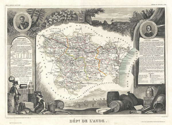
Dept. de L'Aude.
1852 (undated) 12 x 16.5 in (30.48 x 41.91 cm)
1852 (undated) 12 x 16.5 in (30.48 x 41.91 cm)
Description
This is a fascinating 1857 map of the French department of Aude, France. This area of France is famous for its wide variety of vineyards and wine production. In the east are the wines of Corbieres and la Clape, in the center are Minervois and Côtes de Malpeyre, and in the south, blanquette de Limoux. The whole is surrounded by elaborate decorative engravings designed to illustrate both the natural beauty and trade richness of the land. There is a short textual history of the regions depicted on both the left and right sides of the map. Published by V. Levasseur in the 1852 edition of his Atlas National de la France Illustree.
Cartographer
Victor Levasseur (1800 - 1870), an important French engineer, cartographer, and engraver of the mid 19th century, held a number of important cartographically related political and educations posts in France. He is most famous for his Atlas National Illustré des 86 Départements et des Possessions de La France, a large decorative atlas of France, including his Planisphere and five important continental maps. Levasseur's maps are distinctive for their wide decorative margins containing elaborate depictions of the scenery, peoples, and trade goods of the areas he mapped. Levasseur maps are also known to offer a wealth of statistical data. Until recently, very few Levasseur Atlases migrated out of France where they were mostly used in public libraries and town halls. His work represents some of the last great decorative atlases of the 19th century. More by this mapmaker...
Source
Levassuer, V., Atlas National Illustre des 86 Departments et des Possessions de La France Divise par Arrondissements, Cantons et Communea avec La Trace de Toutes Les Routes, Chemins,de fer et Canaux., 1852 edition.
Condition
Very good. Blank on verso. Wide clean margins.
References
Phillips (Atlases) 3003.