
1975 Vietnamese Ministry of Education Wall Map of Vietnam during the August Revolution

Cách Mạng Tháng Tám. / August Revolution.
Ho Chi Minh's declaration of Vietnamese independence.
$750.00
Choose a Collection:
This Item
Enquire
Ho Chi Minh's declaration of Vietnamese independence.
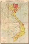
This is a 1975 Vietnamese Ministry of Education wall map of Vietnam depicting the 1945 August Revolution, an armed revolt against the Japanese occupation and French colonial rule.A Closer Look
The map covers the entirety of Vietnam, with nearby countries, waterways, and mountains also outlined. Small illustrations of the Vietnamese Communist flag (now the national flag of Vietnam) mark cities where insurrections occurred, with dates in red. The dark red in extreme northern Vietnam (Tonkin) highlights the region controlled by the Viet Minh, while lighter red shading denotes guerrilla base areas, and orange shading marks war zones (Chiến Khu). Notably, aside from the Viet Minh stronghold of Tonkin, the largest number of uprisings took place in the Mekong Delta. Additional information on specific areas (Thái Nguyên, Lạng Sơn) is provided in the legend.The August Revolution
The August Revolution, also known as the August General Uprising, began in mid-August 1945, and within two weeks the Việt Minh controlled all of Vietnam. This fortuitous position evolved after the Japanese coup d'état in March 1945 that overthrew the puppet French government. The coup exacerbated an already devastating famine, which allowed the Việt Minh the opportunity to organize their 'People's Revolutionary Committees'. When the Japanese surrendered in August 1945, these committees were poised to seize power and did so without hesitation. Two weeks later, on September 2, 1945, Ho Chi Minh declared Vietnamese independence from France, which would lead to the French Indochina War (1946 -1954) and subsequently the American Vietnam War (1855 - 1975).Publication History and Census
This map was created and printed by the State Department of Survey of Geodesy and Mapping (Cục Đo đạc và Bản đồ Nhà nước) and published by the School Equipment Company (Công ty Thiết bị Trường học) of the Vietnamese Ministry of Education (Bộ Giáo dục). It was originally prepared in 1974, with this being a 1975 second edition. Text at the top (Giáo khoa - Lịch sử) suggests that this was one of several such wall maps in a series for classroom use to teach history. We have not been able to locate any other examples of this map in institutional collections or on the market.Condition
Average. Backed on archival tissue for stability. Large area of infill at top center. Old poorly executed repairs have been replaced with archival repairs, but some damage is impossible to undo. Soiling throughout.