1840 Black Map of Australia and New Zealand
Australia-black-1840$200.00

Title
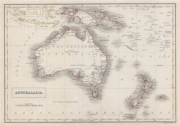
Australasia.
1840 (undated) 11.5 x 16 in (29.21 x 40.64 cm)
1840 (undated) 11.5 x 16 in (29.21 x 40.64 cm)
Description
A fine example of Adam and Charles Black's 1840 map of Australia and New Zealand. The map covers from the east Indies to the Lord Auckland Islands and the Chatam Islands of New Zealand in the Pacific Ocean. It includes New Holland or Australia, New Zealand, Tasmania (then known as Van Diemen's Island), Papua New Guinea and Melanesia. An interesting map issued just as most of the earth's non-polar shore has been explored. Gone are many of the errors of the previous century with the coastlines accurately rendered. Inland though, much remained confused. Vast stretches of unmapped territory and speculative cartography fill central Australia, New Zealand and Papua New Guinea. In 1840, after the signing of the Treaty of Waitangi, the British annexed New Zealand as part of the Australian colony of New South Wales. However, it separated from New South Wales to become a colony in its own right in 1841. This map was engraved by G. Aikman for issue in the 1840 edition of Black's General Atlas.
Cartographer
Charles and Adam Black (fl. 1807 - present) were map and book publishers based in Edinburgh. Charles and his uncle, Adam, both of Edinburgh, Scotland, founded their publishing firm in 1807. They published a series of maps and atlases throughout the 19th century. In addition to an array of atlases, the Black firm is known for their editions of the Encyclopedia Britannica (1817 - 1826) and the first publishing of Sir Walter Scott's novels in 1854. In 1889 the A. & C. Black publishing house moved to London where it remains in operation to this day. More by this mapmaker...
Source
Hall, Sydney, Black's General Atlas: A series of Fifty-Four Maps from the Latest and Most Authentic Sources, Engraved on Steel, In the First Style of the Art, (Edinburgh: Adam and Charles Black) 1840.
Condition
Very good. Blank on verso. Original platemark visible.
References
Philips (atlases) 4334.