This item has been sold, but you can get on the Waitlist to be notified if another example becomes available, or purchase a digital scan.
1851 Tallis and Rapkin Map of Australia
Australia-tallis-1851$200.00

Title
Australia.
1851 (undated) 10.5 x 14 in (26.67 x 35.56 cm) 1 : 17740800
1851 (undated) 10.5 x 14 in (26.67 x 35.56 cm) 1 : 17740800
Description
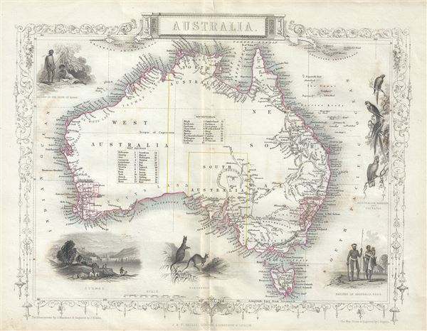
This is a beautiful 1851 example of John Tallis and John Rapkin's 1851 map of Australia. It covers the entire continent of Australia along with Tasmania or as it was known at the time, Van Diemen's Island. An interesting map issued just as most of the earth's non-polar shore has been explored. Gone are many of the errors of the previous century with the coastlines accurately rendered. Inland though, much remained unexplored. Vast stretches of unmapped territory and speculative cartography fill central Australia. The early colonies in Western Australia and New South Wales are noted. In 1851, though not noted on this map, Victoria would become an independent colony separate from New South Wales.
This map is engraved by J. B. Allen and includes illustrations by J. Marchant of Sydney, Natives of the tribe of Bogan, Natives of Australia Felix, Australian Parrots and Cockatoo and Kangaroos. The whole has the highly decorative presentation and elaborate border distinctive of Tallis maps. This map was issued as part of the 1851 edition of John Tallis and Company's The Illustrated Atlas, And Modern History of the World.
This map is engraved by J. B. Allen and includes illustrations by J. Marchant of Sydney, Natives of the tribe of Bogan, Natives of Australia Felix, Australian Parrots and Cockatoo and Kangaroos. The whole has the highly decorative presentation and elaborate border distinctive of Tallis maps. This map was issued as part of the 1851 edition of John Tallis and Company's The Illustrated Atlas, And Modern History of the World.
Cartographer
John Tallis and Company (1838 - 1851) published views, maps, and atlases in London from roughly 1838 to 1851. Their principal works, expanding upon the earlier maps of John Cary and Aaron Arrowsmith, include an 1838 collection of London Street Views and the 1849 Illustrated Atlas of the World. The firm’s primary engraver was John Rapkin, whose name and decorative vignettes appear on most Tallis maps. Due to the embellishments typical of Rapkin's work, many regard Tallis maps as the last bastion of English decorative cartography in the 19th century. Although most Tallis maps were originally issued uncolored, it was not uncommon for 19th century libraries to commission colorists to "complete" the atlas. The London Printing and Publishing Company of London and New York bought the rights for many Tallis maps in 1850 and continued issuing his Illustrated Atlas of the World until the mid-1850s. Specific Tallis maps later appeared in innumerable mid to late-19th century publications as illustrations and appendices. More by this mapmaker...
Source
Tallis, J. and F., The Illustrated Atlas, And Modern History Of The World Geographical, Political, Commercial & Statistical, 1851.
Condition
Very good. Minor wear along original centerfold. Minor spotting. Blank on verso.
References
Rumsey 0466.051. Phillips (Atlases) 804.