1858 Wyld Map of Australia
Australia-wyld-1858$1,000.00
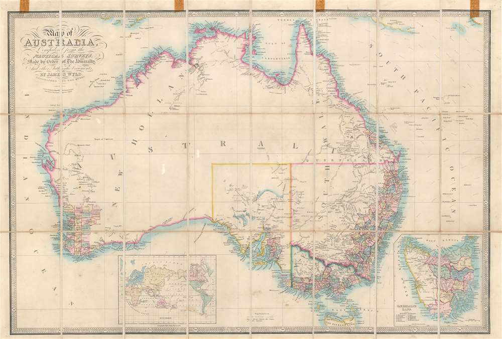

Title
Map of Australia Compiled from the Nautical Surveys, Made by Order of The Admiralty, And other Authentic Documents, By James Wyld Geographer to the Queen.
1858 (undated) 23 x 34.25 in (58.42 x 86.995 cm) 1 : 7350000
1858 (undated) 23 x 34.25 in (58.42 x 86.995 cm) 1 : 7350000
Description
This is a c. 1858 James Wyld map of Australia during the Australian Gold Rush. Depicting the entire continent as well as Tasmania, Wyld illustrates Australia as is being transformed by aggressive colonization and mineral exploitation.
A Closer Look
Counties are most prevalent in New South Wales and Victoria, while a handful had been established in South Australia, Queensland, and modern-day Western Australia. Cities and towns in these counties are labeled, including Sydney, Brisbane, Melbourne, and Perth. Gold veins are indicated by very thin lines, many of which resemble small rivers. Very little inland detail is present, although some lakes and rivers are noted.Australian Gold Rush of 1851
Gold was known to be present in Australia prior to 1851, but the intentional suppression of this information by the colonial government of New South Wales prevented all-out gold rushes. When gold was discovered at Sutter's Mill, California, in 1848, causing the California Gold Rush, countless Australians migrated in search of their fortunes. Desirous of maintaining their dwindling work force, the colonial governors rethought their position, and sought approval from the Colonial Office in England to allow the exploitation of the mineral resources and also offered rewards for the finding of payable gold. This led to the first major Australian gold rush when prospector Edward Hargraves discovered gold at Ophir, near Orange. A series of subsequent discoveries followed, transforming the Australian economy and leading to a rush of new immigration. In Victoria, for example, Melbourne, which had a population of around 29,000 in 1851, grew to over 500,000 by 1861 and then to 700,000 by 1869. This population boom forced the British government to allow the Port Philip District to secede from New South Wales and form the Colony of Victoria. Gold production in Victoria exceeded all other gold producing regions in the world, excepting California, with its highest annual yield reaching 3,053,744 troy ounces in 1856. It is estimated that between 1851 and 1896 a total of 61,034,682 ounces of gold were extracted from mines in Victoria.Publication History of Wyld's Map of Australia
Wyld's Map of Australia is generally underappreciated. Wyld published meticulously updated editions from 1833 until at least 1869, with his son publishing subsequent editions until the 1890s. This attention to detail and regular updates provide an map-to-map historical record Australia's development. Counties proliferate from a small group clustered around Sydney to encompassing the whole of Victoria by the mid-1860s. Here, as stated above, counties spread all along the coasts of New South Wales and Victoria with small enclaves in South Australia and Queensland. At least 22 editions of Wyld's Australia are catalogued by the National Library of Australia, with 20 viewable online, while one of the other 2 are available via the Bibliothèque nationale de France and the State Library of New South Wales.Dating This Edition
Despite a long publication history, Wyld dated the editions of this map only from 1833 to about 1844, with the next dated edition appearing in 1890. Editions between 1844 and 1890 are universally undated, leading to countless cataloging errors. After comparing editions digitized by the National Library of Australia, the State Library of New South Wales, and the Bibliothèque nationale de France, we have created a rough timeline for this map. The present map identifies MacDonnell county, which was not founded until 1857, thus suggesting a c. 1858 publication.Publication History and Census
This map was created by James Wyld and was published c. 1858 in London. While multiple editions of this map do appear in various catalogs, we have not been able to isolate another example of this specific edition.Cartographer
Wyld (1823 - 1893) was a British publishing firm active throughout the 19th century. It was operated by James Wyld I (1790 - 1836) and his son James Wyld II (November 20, 1812 - 1887) were the principles of an English mapmaking dynasty active in London during much of the 19th century. The elder Wyld was a map publisher under William Faden (1749 - 1836) and did considerable work on the Ordinance Survey. On Faden's retirement in 1823, Wyld took over Faden's workshop, acquiring many of his plates. Wyld's work can often be distinguished from his son's maps through his imprint, which he signed as 'Successor to Faden'. Following in his father's footsteps, the younger Wyld joined the Royal Geographical Society in 1830 at the tender age of 18. When his father died in 1836, James Wyld II was prepared to fully take over and expand his father's considerable cartographic enterprise. Like his father and Faden, Wyld II held the title of official Geographer to the Crown, in this case, Queen Victoria. In 1852, he moved operations from William Faden's old office at Charing Cross East (1837 - 1852) to a new, larger space at 475 Strand. Wyld II also chose to remove Faden's name from all of his updated map plates. Wyld II continued to update and republish both his father's work and the work of William Faden well into the late 1880s. One of Wyld's most eccentric and notable achievements is his 1851 construction of a globe 19 meters (60 feet) in diameter in the heart of Leicester Square, London. In the 1840s, Wyld also embarked upon a political career, being elected to parliament in 1847 and again in 1857. He died in 1887 following a prolific and distinguished career. After Wyld II's death, the family business was briefly taken over by James John Cooper Wyld (1844 - 1907), his son, who ran it from 1887 to 1893 before selling the business to Edward Stanford. All three Wylds are notable for producing, in addition to their atlas maps, short-run maps expounding upon important historical events - illustrating history as it was happening - among them are maps related to the California Gold Rush, the New South Wales Gold Rush, the Scramble for Africa, the Oregon Question, and more. More by this mapmaker...
Condition
Good. Dissected and mounted on original linen in 24 panels. Even overall toning. Exhibits light soiling. Brown cellophane tape residue evident along top border. Accompanied by red leather case.