1845 Ewing Map of Australia and Polynesia
AustraliaPolynesia-ewing-1845$150.00

Title
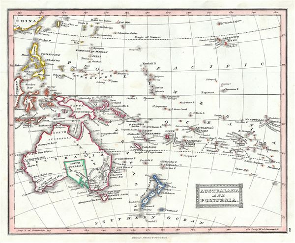
Australia and Polynesia.
1845 (undated) 8 x 9.5 in (20.32 x 24.13 cm) 1 : 16500000
1845 (undated) 8 x 9.5 in (20.32 x 24.13 cm) 1 : 16500000
Description
This is a lovely example of Thomas Ewing's 1845 map of Australia and Polynesia. The map covers from the southern coast of China south to include New Zealand, and east to the Marquesas Islands. It includes Australia, New Zealand, Tasmania (then known as Van Diemen’s Island), Papua New Guinea, the Philippines, and Melanesia. Various rivers, mountains, islands and several other topographical details are noted with relief shown by hachure. This is an interesting map issued just as most of the earth's non-polar shore has been explored. Gone are many of the errors of the previous century with the coastlines accurately rendered. Inland though, much remained confused. Vast stretches of unmapped territory and speculative cartography fill central Australia, New Zealand and Papua New Guinea.
In 1840, after the signing of the Treaty of Waitangi, the British annexed New Zealand as part of the Australian colony of New South Wales. However, it separated from New South Wales to become a colony in its own right in 1841. Victoria became an independent colony separate from New South Wales only in July 1851.
This map was published in 1845 by Oliver and Boyd as part of Ewing's New General Atlas.
Source
Oliver and Boyd, Ewing's New General Atlas: containing Distinct Maps of all the Principal States and Kingdoms throughout the World, (Edinburgh) 1845.
Condition
Very good. Minor foxing at places. Blank on verso.