1990 Government of the Bahamas Pictorial Map of the Bahamas
Bahamas-government-1990$200.00


Title
The Bahamas.
1990 (dated) 29.75 x 20 in (75.565 x 50.8 cm) 1 : 1725000
1990 (dated) 29.75 x 20 in (75.565 x 50.8 cm) 1 : 1725000
Description
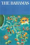
This is a 1990 Government of the Commonwealth pictorial broadside poster map of the Bahamas. Vibrantly colored and beautifully illustrated, the poster exudes 'tropical paradise'. Tourists abound, lounging on beaches, snorkeling, scuba diving, and swimming with dolphins, while locals fish and play music. Birds, such as an egret, a hummingbird, and a flock of flamingos are illustrated on some of the islands, while fish fill the sea. Each of the islands is identified, including New Providence, Andros, and Grand Bahama, and cities, and towns are labeled throughout. A smiling sun situated in the upper right is so bright even it is wearing sunglasses!
Publication History
This poster map was printed by the government of the Bahamas in 1990.Condition
Very good. Light wear along margins. Blank on verso.