1780 Bellin Map of Brazil
BahiaSaoPaolo-bellin-1780$150.00

Title
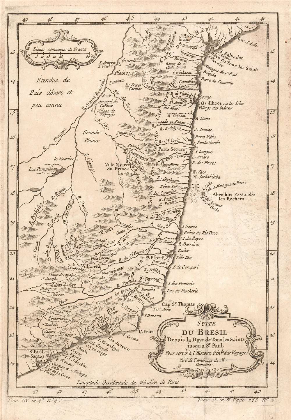
Suite du Bresil Depuis la Baye de Tous les Saints jusqu' a St. Paul. Pour servir à l'Histoire Génle. des Voyages Tiré de l'Amerique de M. Danville.
1780 (undated) 6.5 x 9.25 in (16.51 x 23.495 cm) 1 : 6500000
1780 (undated) 6.5 x 9.25 in (16.51 x 23.495 cm) 1 : 6500000
Description
This is a 1780 map of coastal Brazil, showing the Captaincies of Bahia, Ilheús, Porto Seguro, Espirito Santo, Rio de Janeiro and part of Sao Paolo. These were coastal colonies, and the map's detail does not extend beyond the Rio São Francisco, apart from the descriptive text Étendue de País désert et peu connu (This extent of the country is deserted and little known.) Although composed and engraved by Nicolas Bellin, the cartography is drawn from D'Anville's 1748 Amerique Meridionale, which still represented the most up-to-date cartography in 1753, when this map was engraved.
Publication History and Census
This map was engraved in 1753 for inclusion in La Harpe's Abrégé de l'histoire générale des voyages. The separate map appears on the market from time to time, and in various editions appears in perhaps a dozen institutional collections. La Harpe's work is well represented in institutions.CartographerS
Jacques-Nicolas Bellin (1703 - March 21, 1772) was one of the most important cartographers of the 18th century. With a career spanning some 50 years, Bellin is best understood as geographe de cabinet and transitional mapmaker spanning the gap between 18th and early-19th century cartographic styles. His long career as Hydrographer and Ingénieur Hydrographe at the French Dépôt des cartes et plans de la Marine resulted in hundreds of high quality nautical charts of practically everywhere in the world. A true child of the Enlightenment Era, Bellin's work focuses on function and accuracy tending in the process to be less decorative than the earlier 17th and 18th century cartographic work. Unlike many of his contemporaries, Bellin was always careful to cite his references and his scholarly corpus consists of over 1400 articles on geography prepared for Diderot's Encyclopedie. Bellin, despite his extraordinary success, may not have enjoyed his work, which is described as "long, unpleasant, and hard." In addition to numerous maps and charts published during his lifetime, many of Bellin's maps were updated (or not) and published posthumously. He was succeeded as Ingénieur Hydrographe by his student, also a prolific and influential cartographer, Rigobert Bonne. More by this mapmaker...
Jean Baptiste Bourguignon d'Anville (1697 - 1782) was perhaps the most important and prolific cartographer of the 18th century. D'Anville's passion for cartography manifested during his school years when he amused himself by composing maps for Latin texts. There is a preserved manuscript dating to 1712, Graecia Vetus, which may be his earliest surviving map - he was only 15 when he drew it. He would retain an interest in the cartography of antiquity throughout his long career and published numerous atlases to focusing on the ancient world. At twenty-two D'Anville, sponsored by the Duke of Orleans, was appointed Geographer to the King of France. As both a cartographer and a geographer, he instituted a reform in the general practice of cartography. Unlike most period cartographers, D'Anville did not rely exclusively on earlier maps to inform his work, rather he based his maps on intense study and research. His maps were thus the most accurate and comprehensive of his period - truly the first modern maps. Thomas Basset and Philip Porter write: "It was because of D'Anville's resolve to depict only those features which could be proven to be true that his maps are often said to represent a scientific reformation in cartography." (The Journal of African History, Vol. 32, No. 3 (1991), pp. 367-413). In 1754, when D'Anville turned 57 and had reached the height of his career, he was elected to the Academie des Inscriptions. Later, at 76, following the death of Philippe Buache, D'Anville was appointed to both of the coveted positions Buache held: Premier Geographe du Roi, and Adjoint-Geographer of the Academie des Sciences. During his long career D'Anville published some 211 maps as well as 78 treatises on geography. D'Anville's vast reference library, consisting of over 9000 volumes, was acquired by the French government in 1779 and became the basis of the Depot Geographique - though D'Anville retained physical possession his death in 1782. Remarkably almost all of D'Anville's maps were produced by his own hand. His published maps, most of which were engraved by Guillaume de la Haye, are known to be near exact reproductions of D'Anville' manuscripts. The borders as well as the decorative cartouche work present on many of his maps were produced by his brother Hubert-Francois Bourguignon Gravelot. The work of D'Anville thus marked a transitional point in the history of cartography and opened the way to the maps of English cartographers Cary, Thomson and Pinkerton in the early 19th century. Learn More...
Source
De la Harpe, Abrégé de l'histoire générale des voyages, (Paris) 1780.
Condition
Good. Margin extended on left, but borders complete. Some marginal soiling, original fold lines visible.
References
OCLC 163341814.