This item has been sold, but you can get on the Waitlist to be notified if another example becomes available, or purchase a digital scan.
1812 Direccion Hydrografica Map of the Balaeric Islands: Mallorca, Menorca, Ibiza
BalaericIslands-direccionhydrografica-1812-2$775.00

Title
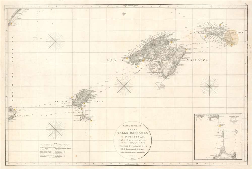
Carta Esferica de las Islas Baleares y Pithyusas, arreglada a la que se construyo en 1807 en la Dirección Hidrografica de Madrid.
1812 (dated) 24 x 35.5 in (60.96 x 90.17 cm) 1 : 450000
1812 (dated) 24 x 35.5 in (60.96 x 90.17 cm) 1 : 450000
Description
A rare 1812 Dirección de Hidrografía nautical chart or maritime map of the Balearic Islands: Mallorca, Minorca, Ibiza and Formentera. The chart offers extraordinarily detail throughout with topography, town names rivers, roads, and depth soundings. An inset in the lower right details the channels between Ibiza and Formentera (1 : 69400).
Publication History and Census
The chart was issued by the Dirección de Hidrografía de Madrid by Don José de Espinoza, one of Spain's great mapmakers. It was engraved and published in London by Edward Jones on behalf of the Dirección de Hidrografía. This chart is extremely rare. We are aware of only one other example held in an institutional collection in Spain.CartographerS
The Direccion Hidrografía (1787 - 1927), also known as the Deposito Hydrografico and the Direction de Hidrografía, was the Spanish equivalent of the British Admiralty or the U.S. Coast Survey. This organization, founded in 1787, was commissioned to collect and produce accurate nautical charts of all waters frequented by Spanish vessels. In essence, it replaced the Casa de la Contratación de las Indias (House of Trade of the Indies), which closed its doors in 1790. Like most such organizations, the Direccion Hidrografía marked a new age in cartography. Rather than simply collect charts created by navigators, explorers, and merchants, the Direccion Hidrografía worked closely with naval and military personnel to mount cartographic and hydrographic expeditions in pursuit of the most accurate hydrographical, astronomical, and geodetic measurements. The Direccion Hidrografía created a massive library of nautical charts that, though not nearly as common as similar nautical charts by the U.S. Coast Survey and British Admiralty, are highly desirable for the beauty of their manufacture as well as their accuracy and detail. The office was originally located on Calle Ballesta, but relocated to 36 Alcala, both in Madrid. After 1908 the Dirección was subsumed into other governmental agencies. In 1927 the Direccion was absorbed into the Institute and Observatory of San Fernando, located in Cadiz. The library of original maps, charts, and journals was transferred to the Naval Museum of Madrid - where it resides to this day. More by this mapmaker...
José Espinosa y Tello (March 25, 1763 - September 8, 1815) was a Spanish nobleman, naval officer, cartographer, hydrographer, and astronomer. Espinosa y Tello was born in Seville, Spain, the son of Miguel Espinosa, Count del Águila, and Isabel María Tello of Portugal. He studied astronomy at the Observatory of Cadiz and hydrography under the great Spanish chartmaker Vicente Tofiño (1732 - 1795) mapping the coasts of Spain. In 1790 he was in Acapulco, Mexico, where he met and joined the Alejandro Malaspina (1754-1809) 1789 to 1794 scientific expedition around the world. After the expedition he served as Assistant of José de Mazarredo of the Dirección General de la Armada and from 1797 headed the Dirección de Hidrografía. Following the Napoleonic Wars he was dispatched to London to manage the compilation and printing of new Spanish nautical charts. On his return to Madrid he was put in charge of the Depósito Hidrográfico. He died there in 1815. Learn More...
Edward Jones (fl. c. 1799 - 1818) was an English engraver active in London during the early part of the 19th century. Jones was born in London, the son of carpenter. He apprenticed first under the engraver Thomas Orphin and later, after Orphin's death, under William Palmer. In 1799, Jones partnered with Benjamin Smith, publishing as alternatively 'Jones and Smith' or 'Smith and Jones.' Around 1801 a third partner, Joseph Bye, was added, and the imprint changed to 'Jones, Smith and Bye' or 'Jones Smith and Company.' The firm dissolved in 1804 when Smith and Bye were captured by French privateers and imprisoned for 4 years while on business trip to Portugal. Jones lived in Newington (London) where he was neighbor of the important engraver and publisher John Rapkin. Learn More...
Condition
Very good. Exhibits soiling in upper right quadrant effecting Minorca. Blank on verso.
References
OCLC 777843585.