This item has been sold, but you can get on the Waitlist to be notified if another example becomes available, or purchase a digital scan.
1751 Bellin Map of Bali, Indonesia
Bali-bellin-1751$112.50

Title
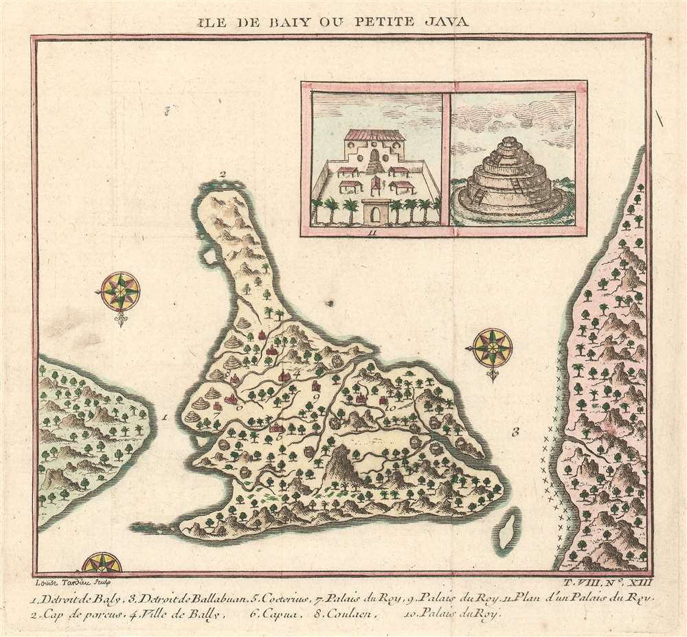
Ile de Baly ou Petite Java.
1751 (undated) 5.75 x 6 in (14.605 x 15.24 cm) 1 : 1150000
1751 (undated) 5.75 x 6 in (14.605 x 15.24 cm) 1 : 1150000
Description
This is an extremely attractive 1751 Jacques-Nicolas Bellin map of Bali, Indonesia. The map depicts the island from the north with Java to the right and Lombok to the left. Wonderful detail of inland rivers and villages is illustrated along with an inset of the Royal Palace and a Balinese temple is situated in the upper right corner. Two and a half compass roses decorate the image. An index of eleven numerically identified locations throughout the island is situated along the bottom border. The cartography is based on a 17th century map created by Willem Lodewijcksz, a member of Cornelius de Houtman's pioneering 1595-97 voyage to the East Indies.
Census and Publication History
This map was created by Jacques-Nicolas Bellin and engraved by Jeanne-Louise-Françoise Duvivier (Tardieu) in 1751. This map is scarce on the market.CartographerS
Jacques-Nicolas Bellin (1703 - March 21, 1772) was one of the most important cartographers of the 18th century. With a career spanning some 50 years, Bellin is best understood as geographe de cabinet and transitional mapmaker spanning the gap between 18th and early-19th century cartographic styles. His long career as Hydrographer and Ingénieur Hydrographe at the French Dépôt des cartes et plans de la Marine resulted in hundreds of high quality nautical charts of practically everywhere in the world. A true child of the Enlightenment Era, Bellin's work focuses on function and accuracy tending in the process to be less decorative than the earlier 17th and 18th century cartographic work. Unlike many of his contemporaries, Bellin was always careful to cite his references and his scholarly corpus consists of over 1400 articles on geography prepared for Diderot's Encyclopedie. Bellin, despite his extraordinary success, may not have enjoyed his work, which is described as "long, unpleasant, and hard." In addition to numerous maps and charts published during his lifetime, many of Bellin's maps were updated (or not) and published posthumously. He was succeeded as Ingénieur Hydrographe by his student, also a prolific and influential cartographer, Rigobert Bonne. More by this mapmaker...
Jeanne-Louise-Françoise Duvivier (c. 1733 - April 6, 1762) was the first wife of Jacques-Nicolas Tardieu (September 2, 1716 - July 9, 1791) and the daughter of Jean Duvivier (1687 - April 30, 1761) the celebrated engraver. She is on record as having engraved several pieces herself. Learn More...
Condition
Very good. Even overall toning. Light wear along original fold lines. Blank on verso.
References
OCLC 868188537.