This item has been sold, but you can get on the Waitlist to be notified if another example becomes available, or purchase a digital scan.
1874 Gray Map of Baltimore, Maryland
Baltimore-gray-1874$67.50

Title
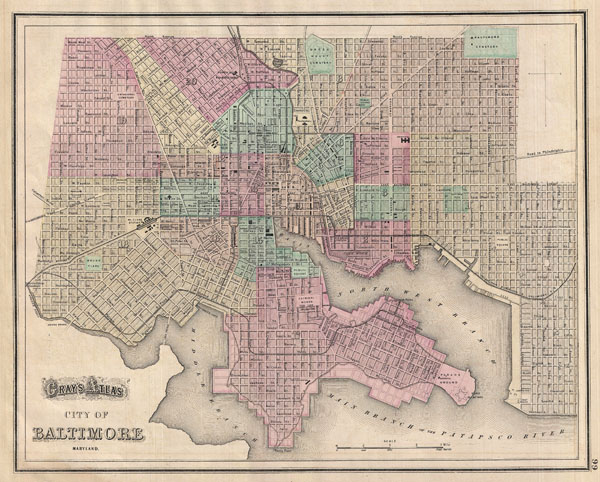
Gray's Alas City of Baltimore Maryland.
1874 (undated) 12 x 15.5 in (30.48 x 39.37 cm)
1874 (undated) 12 x 15.5 in (30.48 x 39.37 cm)
Description
A fine map of Baltimore from Gray's 1874 Atlas of the United States. Covers the entire city from Gwinn's Falls to Seventh Street and from Green Mountain Cemetery to the Patapsco River. Shows proposed landfills along the water's edge. Important churches, transport hubs, and civic buildings are noted throughout. Hand colored in red, green, and yellow pastels according to city ward. Lower left features a decorative title in embellished text – uncommon for Gray who was a minimalist in this regard.
Cartographer
Ormando Wyllis Gray (March 3, 1829 – July 6, 1912) was a mid to late 19th century map publisher with offices in New York City, Philadelphia, PA, and Danielsonville, Connecticut. Born in Townshend, Vermont, he attended Norwich College where he studied civil engineering and became a civil engineer and surveyor. Gray's first commercial atlas was an 1869 survey of Windhamd and Toland counties, Connecticut. His most important work seems to have been done in conjunction with other, more prominent map publishers, including Henry Walling and G.W. and C.B. Colton. Gray is best known for his state and county atlases, though did, with his sons, also independently issue at least two national atlases in the late 1870s. He retired from the map publishing business in 1890. He died at home in Bernardston, Massachusetts. He married Roxcena L. Arnold in 1851, with whom he had three daughters and one son. More by this mapmaker...
Source
Gray, O., Gray's Atlas, 1874.
Condition
Very good condition. Even overall toning. Partial map on verso.