1945 British Army Map of Bali, Lombok, and Environs, Indonesia
Banjoewangi-british-1944$950.00

Title
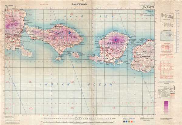
Banjoewangi. HIND 5002 Sheet SC-50/NW.
1944 (dated) 23 x 33.75 in (58.42 x 85.725 cm) 1 : 500000
1944 (dated) 23 x 33.75 in (58.42 x 85.725 cm) 1 : 500000
Description
This is a 1944 British Army map of Bali and Lombok and environs in Indonesia. The map depicts the region from extreme eastern Java to the western part of Soembawa and from the Java Sea to the Indian Ocean. Highly detailed, towns and villages, as well as coastal locations, are labeled on all four islands. Topography is indicated through the use of different shades of purple. Roads are illustrated on all four islands as well, and a railway is indicated by the solid black line on Java. Penida Island is also illustrated. A key is situated along the right border, along with other information explaining how best to use this map.
This map was compiled drawn and printed by 157 (E.A. and S.R.) Base Survey Company, E.A.E. in November 1944.
This map was compiled drawn and printed by 157 (E.A. and S.R.) Base Survey Company, E.A.E. in November 1944.
Condition
Good. Even overall toning. Light soiling. Wear along original centerfold. Some areas of slight loss in margins. Blank on verso.