This item has been sold, but you can get on the Waitlist to be notified if another example becomes available, or purchase a digital scan.
1963 Loeches and Navarro Pictorial Map of Barcelona, Spain
Barcelona-loeches-1963$75.00

Title
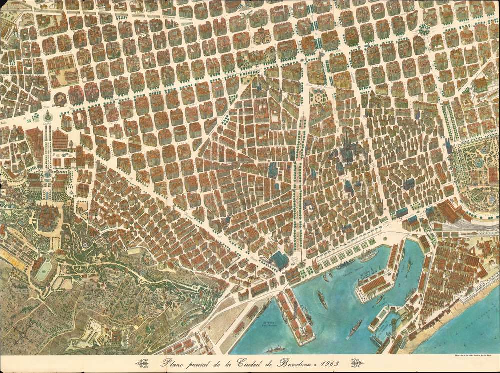
Plano parcial de la Ciudad de Barcelona.
1963 (dated) 24.5 x 33 in (62.23 x 83.82 cm)
1963 (dated) 24.5 x 33 in (62.23 x 83.82 cm)
Description
This is a 1963 José Loeches and José Ruiz Navarro pictorial map of Barcelona, Spain. Created in the style of late 19th and early 20th century 'monumental' maps, the map blends together a city plan and a view. All of Barcelona's buildings are drawn at a slight angle, allowing the viewer to have an understanding of what the building looks like as they walk past it. Stretching from the Poble Espanyol (Pueblo Español de Montjuich to the Parque de la Ciudadela (Ciutadella Park) and from the Estacion de Sans (Barcelona Sants train station) to Mediterranean Sea, each building within the maps scope is illustrated in detail. Barcelona Cathedral, just to the right of center, immediately draws the viewer's attention. Streets throughout the city are labeled, as are squares and plazas. Sixty-eight locations around the city are numerically labeled and correspond with an index printed on the verso. Among these locations are several museums, churches, schools, and government buildings.
Publication History and Census
This map was drawn by José Loeches, colored by José Ruiz Navarro, and published by the Undersecretary of Tourism in 1963. Six examples are cataloged in the OCLC as being part of institutional collections at the Library of Congress, Pennsylvania State University, the University of Illinois at Urbana-Champaign, Florida State University, the University of California Santa Barbara, and the Biblioteca Nacional de España in Madrid.Cartographer
José Loeches (fl. c. mid 20th century) was a Spanish artist. Little is known about his life and career, only that he produced two bird's-eye view style city plans in the early 1960s: one of Madrid celebrating its 400th anniversary and another of Barcelona. More by this mapmaker...
Condition
Good. Even overall toning. Light soiling. Closed tear extending 4.75 inches into printed area professionally repaired on verso. Verso repairs to fold separations. Text and map of greater Barcelona on verso.
References
OCLC 5477931.