This item has been sold, but you can get on the Waitlist to be notified if another example becomes available.
1953 Rubincam Pictorial Map of the Battlefield of Gettysburg
BattlefieldGettysburg-rubincam-1953$200.00

Title
The Battlefield of Gettysburg.
1953 (dated) 16.25 x 21.75 in (41.275 x 55.245 cm)
1953 (dated) 16.25 x 21.75 in (41.275 x 55.245 cm)
Description
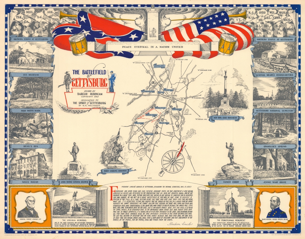
Published during the 90th anniversary of the Battle of Gettysburg, this is a 1953 Barclay Rubincam pictorial map of the battlefield of Gettysburg. Illustrating the battlefield and its environs, important battle sites and the locations of monuments and museums are identified.
A Closer Look
Thirteen illustrations frame the battlefield map highlighting locations either important to the battle or monuments erected afterwards. Among these are General Lee's headquarters, General Meade's headquarters, the High Water Mark, the New York, North Carolina, and Virginia Monuments, and, the Gettysburg National Cemetery. All are labeled alphabetically (A-M) and their locations on and around the battlefield identified. Blue banners mark other important sites including the Peach Orchard, the Bloody Angle, and the Wheatfield. A large arrow illustrates Pickett's Charge. The top border features the Peace Memorial flanked by Union and Confederate flags. Wind heads blowing gigantic trumpets appear on either side, with clouds bearing the abbreviations of states that had troops at Gettysburg. At bottom center a banner contains the text of the 'Gettysburg Address'.Publication History and Census
This map was drawn by Barclay Rubincam, lithographed by William N. Cann, Inc. of Wilmington, Delaware, and sold and distributed by Bookmart of Gettysburg, Pennsylvania. We note a single cataloged example which is part of the David Rumsey Map Collection. We have found only a handful of sales records from the last twenty years.Cartographer
Barclay Lawrence Rubincam (July 2, 1920 - June 24, 1978) was an American artist who specialized in historical and natural scenes of his home: Chester County, Pennsylvania. Born in Green Valley, Pennsylvania (near Unionville), Rubincam spent his childhood on a family farm and met his wife as a teenager working at the Warner Theater in West Chester as an usher. After high school Rubincam attended the Wilmington Academy of Art, studying under N.C. Wyeth, Gayle Porter Hoskins, and Frank Schoonover. From 1942 until 1945 Rubincam served in the U.S. Army first as part of an engineering unit in the South Pacific and then as a member of the Army information education section for which he created posters and other illustrations. After getting out of the Army Rubincam spent the rest of his life working as an artist. By the time of his death, Rubincam had become 'practically an institution in Chester County' and was 'an important realist in the Brandywine school'. More by this mapmaker...
Condition
Very good. Closed margin tears professionally repaired on verso.
References
Rumsey 9624.000. Does not appear in OCLC.