This item has been sold, but you can get on the Waitlist to be notified if another example becomes available, or purchase a digital scan.
1759 Gibson Map of Battle of Quebec, Canada during the French and Indian War
BattleQuebec-gibson-1759$100.00

Title
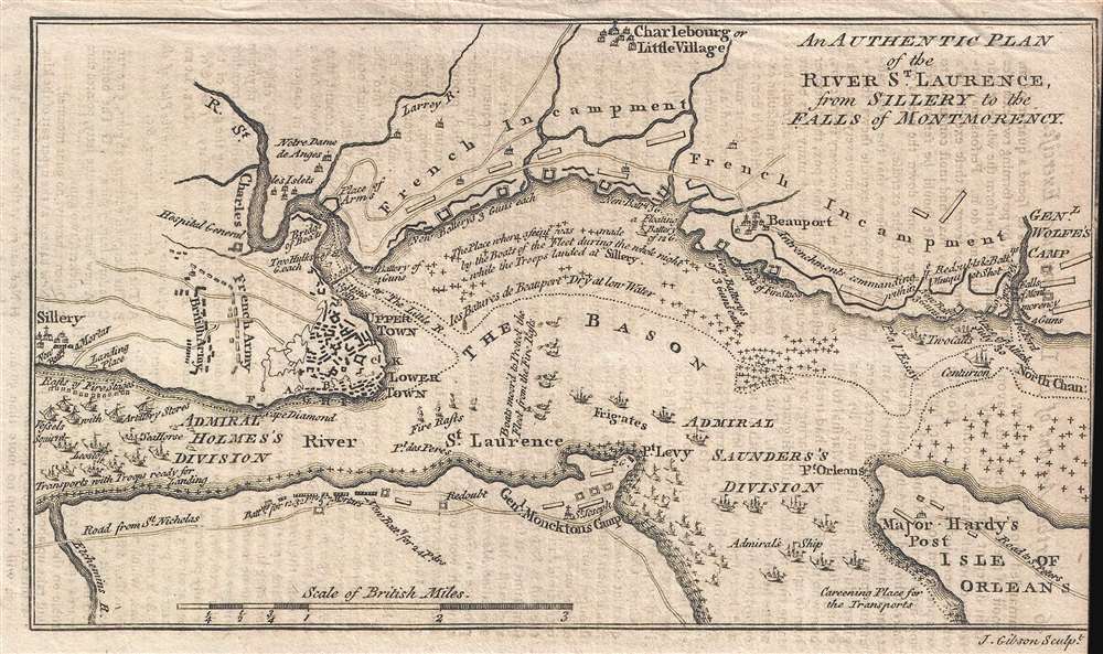
An Authentic Plan of the River St. Laurence, from Sillery to the Falls of Montmorency.
1759 (undated) 4.5 x 7.5 in (11.43 x 19.05 cm) 1 : 50000
1759 (undated) 4.5 x 7.5 in (11.43 x 19.05 cm) 1 : 50000
Description
This is a 1759 John Gibson map of the Battle of Quebec during the French and Indian War, the name for the North American theater during the 7 Years' War between Britain and France. Also known as the Battle of the Plains of Abraham, the map depicts the region from the sillery to Montmorency Falls and from Charlebourg to the Isle of Orleans (Isle d'Orléans). The blockading British fleet is illustrated in the St. Lawrence, while French encampments are labeled all along the river from Quebec City to the Montmorency Falls. The battle, which took place to the west of Quebec City, is illustrated by French and British battle lines.
the Battle of Quebec or the Battle of the Plains of Abraham
Each aspect of the battle is illustrated here, from the British naval blockade of Quebec City to the French attempt to chase away the British fleet by using boats set afire. Soon, however, the British elected to land a force on the north side of the river and engage the French, hopefully on the plains to the west of Quebec City, known as the Plains of Abraham, as these fields had once been owned by a farmer named Abraham Martin. The British, under the command of General James Wolfe, landed upstream from Quebec at L'Anse-au-Foulon, three miles upstream from Cap Diamant. A lightly guarded stretch of riverbank, Wolfe and his men were able to easily overpower the meager French defense and march on Quebec. This move prompted General Louis-Joseph, Marquis de Montcalm to leave the fortifications of Quebec City and fight Wolfe. In a battle that lasted less than an hour between fewer than 10,000 troops between both sides, both commanding generals received mortal wounds. Wolfe was shot three times and died within minutes of the beginning of the battle, while Montcalm succumbed to a gunshot wound to the abdomen the following morning. The French lost the Battle of the Plains of Abraham and were forced to surrender Quebec City, and would end up ceding all of their Canadian territory to the British a few years later as part of the 1763 Treaty of Paris.Publication History and Census
This map was engraved by John Gibson and published in 1759 for Gentleman's MagazineCartographer
John Gibson (1724 – 1773) was an English map engraver active in London at the end of the 18th century. Gibson was the son of a locksmith. In 1739 he apprenticed to John Blundell as a stationer of Grub Street. Gibson proved a fine engraver and was much in demand by London map publishers. During his career he produced thousands of maps and was admired as a skilled engraver and sculptor. Among others, he engraved for Emanuel Bowen, Robert Sayer, Jean Palairet, John Rocque, Andrew Dury, and Benjamin Martin. His best known work was prepared in conjunction with Gentleman's Magazine. Gibson, sadly, was not as astute in his fiscal affairs as with the engravers pen and consequently spent much of his life consigned to debtor's prison. More by this mapmaker...
Condition
Very good. Very close right margin. Light transference from text. Blank on verso.
References
OCLC 950941832.