This item has been sold, but you can get on the Waitlist to be notified if another example becomes available, or purchase a digital scan.
1847 Hardcastle Map of Battle of Mexico City during the Mexican-American War
BattlesofMexico-hardcastle-1847$125.00

Title
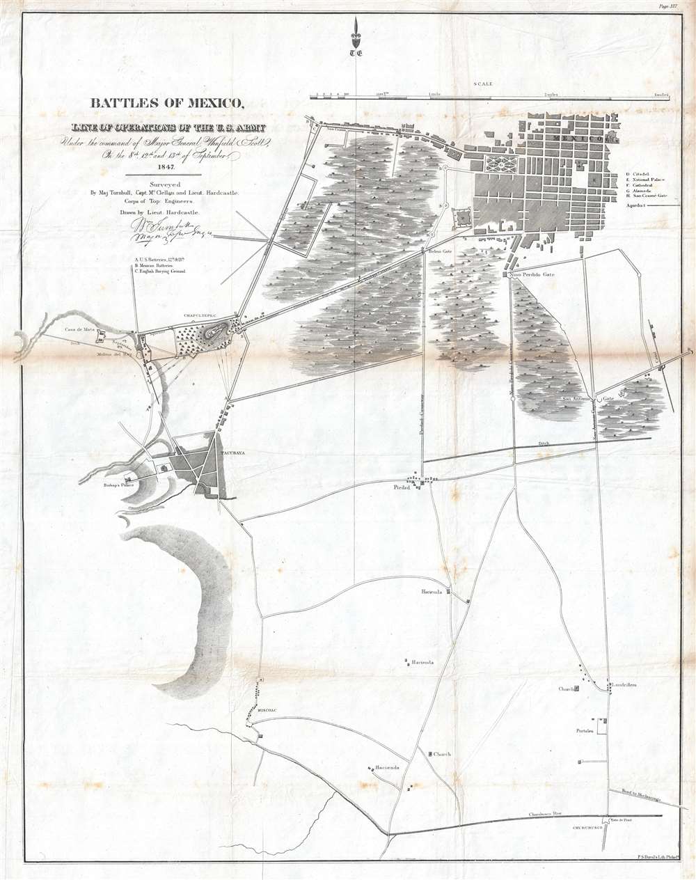
Battles of Mexico, Line of Operations of the U.S. Army under the command of Major General Winfield Scott, on the 8th, 12th and 13th of September, 1847.
1847 (undated) 29 x 23 in (73.66 x 58.42 cm) 1 : 15840
1847 (undated) 29 x 23 in (73.66 x 58.42 cm) 1 : 15840
Description
This is an 1847 Edmund Hardcastle map of the engagements that make up the Battle of Mexico City during the Mexican-American War. The map depicts the region from the Casa de Mata near the Molino del Rey to several sites of Mexican gun batteries to the east of the San Antonio Gate and from Mexico City itself to Churubusco. Led by General Winfield Scott, American forces executed an amphibious landing and captured the port of Veracruz. The army then marched across Mexico, winning victories at the Battle of Cerro Gordo and the Battle of Churubusco, which was located only five miles outside Mexico City. Numerous artillery batteries, both American and Mexican, are identified alphabetically and correspond to information provided in the key. The citadel, national palace, cathedral, and Alameda (Alameda Central) are also identified.
The Battle of Mexico City
After the U.S. army defeated the Mexicans at the Battle of Churubusco, General Scott set his eyes capturing Mexico City and ending the war. A series of engagements followed, which culminated in the fall of Mexico City. First, Scott believed that a Mexican cannon foundry was operating at the Molino del Rey. On September 8th, Scott ordered General William J. Worth and the 1st Division to take the Molino del Rey, which they did, though it produced no major military gains for the U.S. forces. The Battle of Chapultepec (a castle then located just outside Mexico City and guarding its western approaches) followed on September 12, when Scott ordered a day-long artillery barrage of the castle. The following day, September 13, General John Quitman let the 4th Division in an infantry assault on Chapultepec and easily captured the fortress. U.S. forces, under Generals Quitman and Worth, continued down the two causeways leading from Chapultepec into the city, although they were only supposed to feign an attack. Quitman faced resistance at the Belem Gate, while Worth and his troops fought defenders at the San Cosme Gate. Soon, Worth had broken through the defenses at the San Cosme Gate and marched into the Alameda at the center of Mexico City, which effectively ended the war.Publication History and Census
This map was drawn by Lieutenant Edmund La Fayette Hardcastle and published in a U.S. government report in 1847. Though fairly well represented in institutional collections, this map rarely appears on the private market.CartographerS
Edmund La Fayette Hardcastle (October 18, 1824 - August 11, 1899) was an American military officer, politician, and businessman. Born in Denton, Maryland, Hardcastle attended the Unites States Military Academy at West Point from 1842 - 1846, after which he was commissioned a Brevet Second Lieutenant in the Army Corps of Topographical Engineers. He was immediately assigned to the United States Coast Survey, but was soon transferred to participate in the Mexican American War. Hardcastle saw action I the Siege of Vera Cruz, the Battle of Cerro Gordo, the Skirmish of Amazoque, the capture of San Antonio, the Battle of Churubusco, the Battle of Molino del Rey, the Battle of Chapultepec, and the assault and capture of Mexico City. He was twice promoted for meritorious conduct on the battlefield, once after the battles of Contreras and Churubusco, Gand again following the Battle of Molino del Rey, attaining the rank of Brevet Captain. After the war, he held the position fo Assistant in the Topographical Bureau at Washington, D.C., and also was a member of the Mexican Boundary Survey from February 1849 until June 1852. Hardcastle finally received his formal commission as a Second Lieutenant in the Topographical Engineers on September 26, 1849. He then served as the Engineer Secretary of the Light-house Board at Washington, D.C. from October 1852 until April 30, 1856 when he resigned his commission. Hardcastle returned home to Maryland, where he began farming in Talbot County. He served on several boards and as president of the Maryland and Delaware Railroad Company in 1868. He also served as a member of the House of Delegates of the Maryland Legislature from 1870 until 1878. Edmund Hardcastle passed away at Towson, Maryland on August 11, 1899. More by this mapmaker...
Peter Stephen Duval (1804 - February 8, 1886) was a prominent Philadelphia lithographer. He immigrated to Philadelphia from France in 1831 to take a job as a lithographer at the Philadelphia firm owned by Cephas Childs. In 1837, Childs retired and Duval took over the business. Over the course of the next thirty years, Duval would have several business partners including the Swiss-American engravers Charles and Frederick Bourquin (1808 - 1897). In 1857 his son Steven C. Duval joined the business. Peter Duval retired in 1869 but continued to be involved in his company until his death in 1886. Learn More...
Condition
Very good. Toning along original fold lines. Foxing. Some creasing. Closed tear extending 1.5 inches from top border into printed area professionally repaired on verso. Blank on verso.
References
OCLC 39881096.