This item has been sold, but you can get on the Waitlist to be notified if another example becomes available, or purchase a digital scan.
1935 Diemer Bird's Eye View and Relief Map of the Bavarian Highlands
BavarianHighlands-diemer-1935$300.00

Title
Relief-Karte vom Bayerischen Hochland.
1935 (undated) 19.25 x 27.5 in (48.895 x 69.85 cm)
1935 (undated) 19.25 x 27.5 in (48.895 x 69.85 cm)
Description
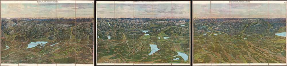
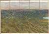
This is a beautiful c. 1935 chromolithograph view of the Bavarian Highlands (or Bavarian Alps) illustrated by Zeno Diemer in three sheets. It was made to promote tourism to the region, which had seen extreme political turmoil in the preceding years, even by the standards of interwar Germany.
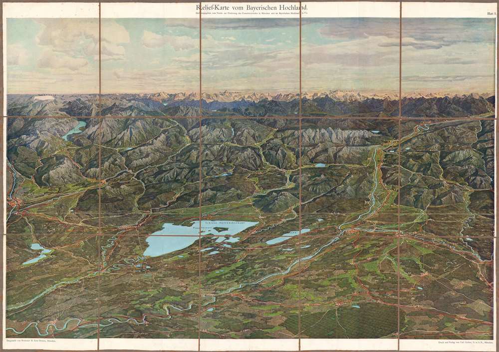
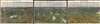
Sheet (Blatt) 1 covers the southeasternmost portion of Bavaria. At center-left is Schloss Herrenchiemsee, a palace on the Chiemsee located on an island called Herreninsel ('gentlemen's island'), which had been home to an Augustinian monastery before the palace was constructed. The palace, modelled on Versailles, was the final of several monumental architecture projects of the eccentric King of Bavaria, Lugwig II (r. 1864 – 1886).
The ancient and historically important city of Salzburg, birthplace of Mozart, is at far left just over the Saalach River. Behind it in the distance are the Berchtesgaden Alps, including their highest peak, the Hochkönig, and below it the Königssee. Just in front of the Königssee is the village of Berchtesgaden and the peak of Hoher Göll; soon after this view was published, the Nazis would construct the Kehlsteinhaus (known in English as the Eagle's Nest) which Hitler and other Nazi leaders occasionally used as a headquarters throughout World War II.
In the distance at center-top is the Grossglockner, the highest mountain peak in Austria, the Großvenediger, and other peaks of the Austrian Alps. Along the right side is the Inn River, a tributary of the Danube that flows through Austria and Switzerland.
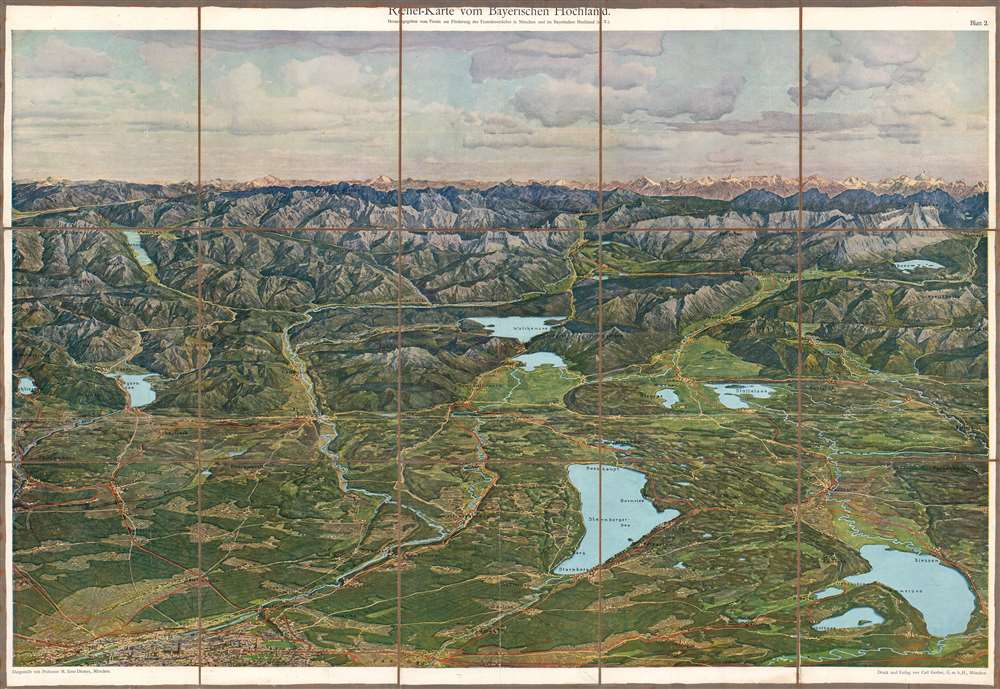
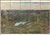
Sheet 2 takes in the southern edge of Munich with lakes and resort towns to the south also known as the 'Land of Five Lakes' (Fünfseenland, although, in fact, there are more than five lakes). At top-center, the town of Scharnitz sits in a valley (the Hinterautal) between the mountains, just over the modern border in Austria, towards Innsbruck.
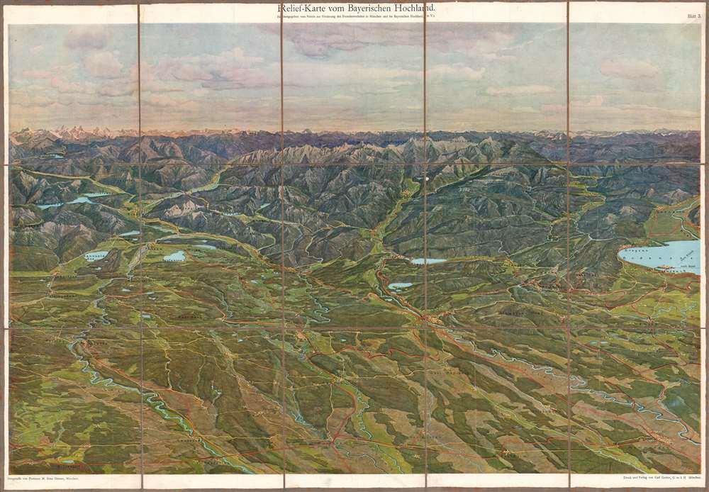
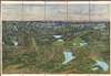
Sheet 3 includes the Bavarian portion of Lake Constance (Bodensee) at right, including the town of Lindau, showing ferry connections with Basel and Zurich. Across the lake is the Alpine Rhine, which feeds into Lake Constance and continues on as a tributary of the Rhine.
In April, a Bolshevik-inspired Bavarian Soviet Republic was founded, attempting to seize power from the more moderate socialists leading the republic. The Soviet Republic enacted a series of radical reforms which added to the already severe privations of the economy, alienating the population which they claimed to rule. For a time, Bavaria had two rival left-wing governments, but the moderates made a deal to enlist the Freikorps, paramilitary veterans of the recent conflict, to attack and eventually crush the Bavarian Soviet Republic. Intense battles raged in the streets of Munich in early May 1919 and in the aftermath hundreds of Communists and Anarchists were executed. In August, a new constitution was enacted creating the Free State of Bavaria within the Weimar Republic.
The violence of 1918 - 1919 in Munich and Bavaria had several important legacies, including a deep aversion to radical leftism that later benefitted the Nazi Party, which was founded and headquartered in Munich. Amid the unrest and violence of Munich in these years were Adolf Hitler and several the other early leaders of the Nazis (despite his later anti-Communism, Hitler had served in the military forces of the Bavarian Soviet Republic, a fact he suppressed later in life). The Nazis used Munich and Bavaria as a stronghold and grew steadily, even after the failed Berr Hall Putsch in 1923, though with little electoral success until the early 1930s. By the mid-1930s, when this view was likely published, the Nazis were already in power throughout Germany.
A Closer Look
This view, divided into three sheets, faces towards the south and moves successively from east to west, across a gorgeous landscape of high hills and glacial lakes. The upper portion of the three sheets reaches the modern border between Bavaria and Austria as it nears the horizon.Sheet (Blatt) 1 covers the southeasternmost portion of Bavaria. At center-left is Schloss Herrenchiemsee, a palace on the Chiemsee located on an island called Herreninsel ('gentlemen's island'), which had been home to an Augustinian monastery before the palace was constructed. The palace, modelled on Versailles, was the final of several monumental architecture projects of the eccentric King of Bavaria, Lugwig II (r. 1864 – 1886).
The ancient and historically important city of Salzburg, birthplace of Mozart, is at far left just over the Saalach River. Behind it in the distance are the Berchtesgaden Alps, including their highest peak, the Hochkönig, and below it the Königssee. Just in front of the Königssee is the village of Berchtesgaden and the peak of Hoher Göll; soon after this view was published, the Nazis would construct the Kehlsteinhaus (known in English as the Eagle's Nest) which Hitler and other Nazi leaders occasionally used as a headquarters throughout World War II.
In the distance at center-top is the Grossglockner, the highest mountain peak in Austria, the Großvenediger, and other peaks of the Austrian Alps. Along the right side is the Inn River, a tributary of the Danube that flows through Austria and Switzerland.
Sheet 2 takes in the southern edge of Munich with lakes and resort towns to the south also known as the 'Land of Five Lakes' (Fünfseenland, although, in fact, there are more than five lakes). At top-center, the town of Scharnitz sits in a valley (the Hinterautal) between the mountains, just over the modern border in Austria, towards Innsbruck.
Sheet 3 includes the Bavarian portion of Lake Constance (Bodensee) at right, including the town of Lindau, showing ferry connections with Basel and Zurich. Across the lake is the Alpine Rhine, which feeds into Lake Constance and continues on as a tributary of the Rhine.
Placid Scene Amid Tumultuous Events
The serenity of this view belies the recent history of the region. Aside from the general suffering caused by the First World War, Munich became a hotbed of revolutionary activity in the months after the Armistice in November 1918. Before the Armistice even went into effect, the Bavarian monarchy was overthrown and a republic proclaimed, led by the socialist Kurt Eisner. Eisner was assassinated by a far-right radical in February 1919 and the political situation became very chaotic and violent.In April, a Bolshevik-inspired Bavarian Soviet Republic was founded, attempting to seize power from the more moderate socialists leading the republic. The Soviet Republic enacted a series of radical reforms which added to the already severe privations of the economy, alienating the population which they claimed to rule. For a time, Bavaria had two rival left-wing governments, but the moderates made a deal to enlist the Freikorps, paramilitary veterans of the recent conflict, to attack and eventually crush the Bavarian Soviet Republic. Intense battles raged in the streets of Munich in early May 1919 and in the aftermath hundreds of Communists and Anarchists were executed. In August, a new constitution was enacted creating the Free State of Bavaria within the Weimar Republic.
The violence of 1918 - 1919 in Munich and Bavaria had several important legacies, including a deep aversion to radical leftism that later benefitted the Nazi Party, which was founded and headquartered in Munich. Amid the unrest and violence of Munich in these years were Adolf Hitler and several the other early leaders of the Nazis (despite his later anti-Communism, Hitler had served in the military forces of the Bavarian Soviet Republic, a fact he suppressed later in life). The Nazis used Munich and Bavaria as a stronghold and grew steadily, even after the failed Berr Hall Putsch in 1923, though with little electoral success until the early 1930s. By the mid-1930s, when this view was likely published, the Nazis were already in power throughout Germany.
Chromolithography
Chromolithography, sometimes called oleography, is a color lithographic technique developed in the mid-19th century. The process involved using multiple lithographic stones, one for each color, to yield a rich composite effect. Oftentimes, the process would start with a black basecoat upon which subsequent colors were layered. Some chromolithographs used 30 or more separate lithographic stones to achieve the desired product. Chromolithograph color could also be effectively blended for even more dramatic results. The process became extremely popular in the late 19th and early 20th centuries, when it emerged as the dominant method of color printing. The vivid color chromolithography produced made it exceptionally effective for advertising and propaganda imagery.Publication History and Census
This view was illustrated by Zeno Diemer for the Association for the Promotion of Tourism in Munich and in the Bavarian Highlands (Verein zur Förderung des Fremdenverkehrs in München und im Bayerischen Hochland). It was printed and published in Munich by Carl Gerber. As the view is undated and consists of three sheets which are sometimes cataloged individually, there are several entries in OCLC of what may or may not be multiple editions. In any event, the view is held by a handful of libraries in Europe and North America. The presentation used in this example, where the view has been separated and mounted on linen as a folding map, appears to be especially rare.CartographerS
Michael Zeno Diemer (February 8, 1867 - February 28, 1939) was a German painter especially known for his huge panoramic paintings of battles. In 1884, he enrolled at the Academy of Fine Arts in Munich (Akademie der Bildenden Künste München), where he studied with Gabriel Hackl (1843 – 1926) and Alexander von Liezen-Mayer (1839 – 1898). More by this mapmaker...
Carl Gerber Verlag (1878 – present) is a publishing house based in Munich and nearby Rohrbach that occasionally publishes maps, along with periodicals and books on a range of topics including the history, culture, and folklore of various cities and regions in Germany. Learn More...
Condition
Good. Some wear along original fold lines. Dissected and mounted on linen. Some foxing in upper-left.