This item has been sold, but you can get on the Waitlist to be notified if another example becomes available, or purchase a digital scan.
1757 Bellin Map of the Chesapeake Bay and Surrounding States
BayeDeChesapeack4-bellin-1757$187.50

Title
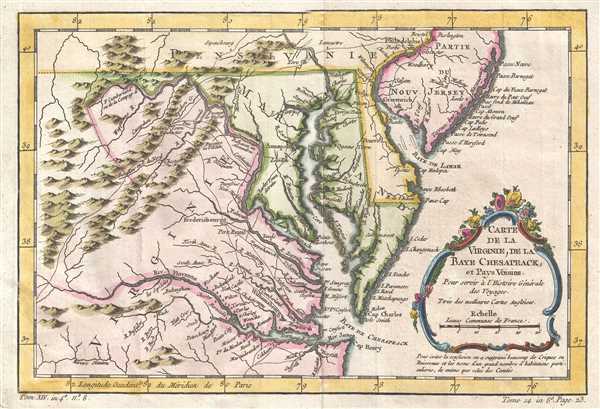
Carte de la Baye de Chesapeack et Pays Voisins.
1757 (undated) 8 x 12 in (20.32 x 30.48 cm) 1 : 2300000
1757 (undated) 8 x 12 in (20.32 x 30.48 cm) 1 : 2300000
Description
This is a beautiful 1757 Jacques-Nicolas Bellin map of the Chesapeake Bay and its environs, including Virginia, Maryland, and Delaware, and parts of New Jersey and Pennsylvania. The map depicts from the Susquehanna River and Burlington, New Jersey to Cape Henry, and inland as far as the Appalachian Mountains. The Chesapeake Bay is shown in full, along with many of its river estuaries. The Chesapeake Bay's western watershed is included, luring potential colonists with the promise of large navigable rivers and rich fertile lands.
In the title cartouche Bellin cites that this map is derived from the 'best English maps' (Turee des Meilleures Cartes Angloises). In this he can only be referring to the Fry-Jefferson map of 1753. Such is apparent from the cartographer's inclusion of Moulin Hoggats (Hoggett's Mill) on the upper Appomattox River. This mill first appeared on the Fry-Jefferson map and did not subsequently reappear on another published map until the present issue.
Bellin prepared this map for issue in the 1757 French edition of Provost's Histoire des Voyages. There are five editions of this map as well as several variant states.
Cartographer
Jacques-Nicolas Bellin (1703 - March 21, 1772) was one of the most important cartographers of the 18th century. With a career spanning some 50 years, Bellin is best understood as geographe de cabinet and transitional mapmaker spanning the gap between 18th and early-19th century cartographic styles. His long career as Hydrographer and Ingénieur Hydrographe at the French Dépôt des cartes et plans de la Marine resulted in hundreds of high quality nautical charts of practically everywhere in the world. A true child of the Enlightenment Era, Bellin's work focuses on function and accuracy tending in the process to be less decorative than the earlier 17th and 18th century cartographic work. Unlike many of his contemporaries, Bellin was always careful to cite his references and his scholarly corpus consists of over 1400 articles on geography prepared for Diderot's Encyclopedie. Bellin, despite his extraordinary success, may not have enjoyed his work, which is described as "long, unpleasant, and hard." In addition to numerous maps and charts published during his lifetime, many of Bellin's maps were updated (or not) and published posthumously. He was succeeded as Ingénieur Hydrographe by his student, also a prolific and influential cartographer, Rigobert Bonne. More by this mapmaker...
Source
Prévost, A., Histoire Générale des Voyages, ou Nouvelle Collection de Toutes les Relations de Voyages par Mer et par Terre..., (Paris: Didot) 1746 - 1759, Supplements 1761 - 1801.
Prévost's Histoire Générale des Voyages is a 15-volume compendium of travel literature initiated by Antoine François Prévost (Provost; 1697 - 1763) in 1746, intended as a universal history of exploration and geography. The initial publication, compiled from 1746 to 1759, spans 15 volumes and draws from a vast array of sources - travelers, explorers, missionaries, merchants, and diplomats - to present detailed narratives of significant global journeys. The work was initially published in Paris by Didot and offers ethnographic, political, religious, and natural observations about the peoples, cultures, flora, fauna, and geography. It is an ambitious attempt to organize knowledge about the world's diversity according to Enlightenment values, reflecting both scientific curiosity and imperial ideology. It functioned as both an informative reference and a literary work, influencing how European audiences understood and imagined distant lands. It proved extremely successful, and both reissues other publishers and pirate editions emerged, most notably Pierre de Hondt's 1747 Dutch edition and Jean-Franćois de la Harpe's 1780 abridged version. In addition to reissues of the original work, between 1768 and 1801, additional expanded volumes emerged, adding new voyages and histories. We have seen some sets with as many as 80 volumes. Over time, the Histoire générale des voyages became one of the most comprehensive and widely read travel collections of the 18th century, notable for blending factual reporting with the period's characteristic intellectual ambition.
Condition
Very good. Minor wear along original fold lines. Original platemark visible.
References
Library of Congress, Map Division, G3792.C5 1757.B4. Tooley, R.V., 'Printed Maps of America Part IV', in Map Collectors' Series # 96, 113-114, Map nos. 873 And 875. Cumming, William P., The Southeast in Early Maps, 228. Phillips, Philip Lee, Virginia Cartography, 1896, 50, 51, 52. Mathews, Edward B., 'Bibliography and Cartography of Maryland', in Maryland Geological Survey, Vol. 1, Part IV, 348. Sellers, John R. and Van Ee, Patricia, Maps and Charts of North America and the West Indies 1750-1789, nos. 1383, 1437. Sabin, Joseph, A Dictionary of Books Relating to America from its Discovery to the Present Time, # 65402, # 65403. Wooldridge, W., Mapping Virginia from the Age of Exploration to the Civil War, no 105.