This item has been sold, but you can get on the Waitlist to be notified if another example becomes available, or purchase a digital scan.
1775 Jefferys Map of Early British Settlement in Central America
BayofHonduras-jefferys-1775$550.00

Title
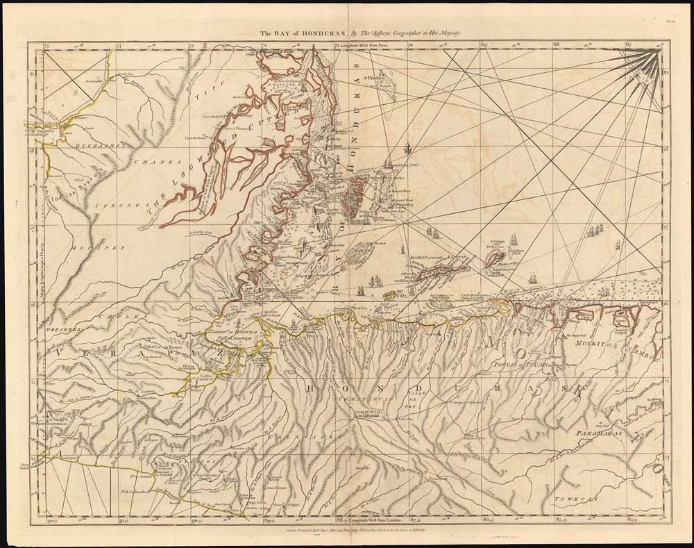
The Bay of Honduras. By Thos. Jefferys Geographer to His Majesty.
1775 (dated ) 19.25 x 24.75 in (48.895 x 62.865 cm) 1 : 1500000
1775 (dated ) 19.25 x 24.75 in (48.895 x 62.865 cm) 1 : 1500000
Description
This 1775 Jefferys map of Belize, Honduras, Guatemala and El Salvador is the earliest, acquirable, detailed map to focus on the region. It is informationally rich, showing anchorages, depth soundings and common sailing routes (replete with dozens of ships.) The region’s plentiful reefs, islands and lagoons are shown and named. This map brings into sharp focus coastal Belize and Honduras where English privateers and merchants had long operated – shortly after Spain began to tolerate their presence, but just prior to Britain’s official administration of Belize as a colony.
Belize
The map provides the reader some of the first glimpses of what is now a favorite vacation spot in Central America. Of Ambergrise Caye (Ambergreese Key on the map) it is noted that there are plenty of deer and ‘ambergreese (is) often found on the beach.’ Cangrejo Caye and Caye Caulker (Corker Key) are shown, as is Blackadore Caye - an island now apparently owned and run as an eco-resort by Leonardo DiCaprio. Some of the world’s best diving sites are charted here: the map’s ‘Four Keys Reef’ corresponds to the Belize Barrier Reef. Half Moon Caye is marked, though the Reef’s famous ‘Blue Hole’ does not appear. This absence is not surprising: the Blue Hole is well within the bounds of the barrier reef, making it virtually inaccessible to navigators of the 18th century. In testament to this, the eastern approach to the reef is marked with four charted sea-wrecks, two of them named. The Placencia region - the point and the famous mangrove lagoon - both appear on the map. The Garifuna towns of Hopkins and Dangriga do not yet appear: though this entire region would see significant Garifuna settlement in the 19th century, the initial marooning of the Garifuna to Roatan island by the British would not occur until 1796, more than twenty years after the production of this map.The Logwood Cutters
The interior of Belize shows significantly less detail than the coast, but identifies the course of the Belize River and the New River, and a network of poorly-understood lagoons. While indigenous tribal names such as the Tipu appear here, more prominent is the domain of ‘THE LOGWOOD CUTTERS,’ referring to the primary export of the region from the earliest colonial period onward. Logwood – like Brazil wood – could be processed to provide a deep red dye, and a superior ‘fast black’. In the 16th century the Spanish harvested logwood from the Yucatan; British pirates commonly stole the cargoes, a single load of which was worth more than a year’s cargo of other merchandise. In the 17th century, the English began to establish logging camps in what would become interior Belize, and these logwood cutters began shipping as much as 13000 tons of logwood to England yearly. Over the course of the 18th century, the baymen systematically used slaves brought from Africa and the West Indies to cut the logwood, many of whom died from disease, malnutrition and at the hands of their owners. The logwood cutters, both black and white, are depicted in the national emblem of Belize, which appears on currency and the Belize flag.Honduras
The northern coast of Honduras is shown from the Gulf of Honduras to Barra Patuca (Patook Point on the map.) RoatánIsland and Guanaja are shown surrounded with sandbars. English settlements are shown in the vicinity of Cape Camaron and in ‘Brewer’s Lagoon,’ now Brus Laguna at the northern edge of the Mosquito Coast. The interior regions of Honduras are shown in greater detail than those of Belize, reflecting the regions longer Spanish colonial presence.Guatemala, El Salvador and Nicaragua
The map shows from Guatemala City eastwards, including most of El Salvador and the northern departments of Nicaragua, including Nueva Segovia.Publication History and Census
This map was engraved and published by Thomas Jefferys in London to accompany the 1776 West India Atlas. The atlas was published by Robert Sayer, and is considered the definitive Revolutionary War Area cartographic work focusing on the Caribbean, Gulf of Mexico, and Antilles. Examples of the separate maps come to market time to time, but are increasingly rare and desirable.CartographerS
Thomas Jefferys (1695 - November 20, 1771) was one of the most prominent and prolific map publishers and engravers of his day. Jefferys was born in Birmingham and was apprenticed to the engraver Emmanuel Bowen in 1735. Later, in the 1740s he engraved several maps for the popular periodical Gentleman's Magazine. Around 1740 Jefferys was finally able to go into business for himself and in 1746 received an appointment as 'Geographer to Fredrick, Prince of Wales,' which shortly after translated to the position of 'Royal Cartographer to King George III.' Jefferys initially specialized in compiling and re-engraving the works of earlier cartographers into more coherent cartographic wholes. Later, while not salaried position, Jefferys' appointment as 'Royal Cartographer' guaranteed preferential access to the most up to date cartographic material available, allowing him to produce new and updated charts of exceptional accuracy. He his best known for his maps of the Americas, particularly the posthumously published 1775 American Atlas, which included some of the finest and most important late colonial era maps of America ever made. Despite his prolific publishing history, royal appointments, and international publishing fame, Jefferys lived most of his life in dire economic straits. He was bailed out of bankruptcy by Robert Sayer during the production of the American Atlas. In the end, Jefferys died suddenly with very little to his name. Nonetheless, his cartographic legacy survived, and even after his death in 1771, many of his important maps continued to be published and republished by Sayer and Bennet, Conrad Lotter, Georges Louis Le Rouge, Laurie and Whittle, and others. Many attribute some of Jefferys best maps to the colorful and criminally inclined Irish cartographic genius Braddock Mead (John Green, c. 1688 - 1757), who is considered the 'secret behind Jefferys.' Jefferys was succeeded by his son, also Thomas, who had little success as a cartographer and eventually partnered with, then sold his stock and plates to William Faden - Jefferys' true heir. More by this mapmaker...
Robert Sayer (1725 - January 29, 1794) was an important English map publisher and engraver active from the mid to late 18th century. Sayer was born in Sunderland, England, in 1725. He may have clerked as a young man with the Bank of England, but this is unclear. His brother, James Sayer, married Mary Overton, daughter-in-law of John Overton and widow of Philip Overton. Sayer initially worked under Mary Overton, but by December of 1748 was managing the Overton enterprise and gradually took it over, transitioning the plates to his own name. When Thomas Jefferys went bankrupt in 1766, Sayer offered financial assistance to help him stay in business and, in this way, acquired rights to many of the important Jefferys map plates as well as his unpublished research. From about 1774, he began publishing with his apprentice, John Bennett (fl. 1770 - 1784), as Sayer and Bennett, but the partnership was not formalized until 1777. Bennett retired in 1784 following a mental collapse and the imprint reverted to Robert Sayer. From 1790, Sayer added Robert Laurie and James Whittle to his enterprise, renaming the firm Robert Sayer and Company. Ultimately, Laurie and Whittle partnered to take over his firm. Sayer retired to Bath, where, after a long illness, he died. During most of his career, Sayer was based at 53 Fleet Street, London. His work is particularly significant for its publication of many British maps relating to the American Revolutionary War. Unlike many map makers of his generation, Sayer was a good businessman and left a personal fortune and great estate to his son, James Sayer, who never worked in the publishing business. Learn More...
Source
Sayer, R. The American Atlas: Or, A Geographical Description Of The Whole Continent Of America ... Engraved On Forty-Eight Copper Plates, By The Late Mr. Thomas Jefferys, Geographer to the King, and Others. London, Printed and Sold by R. Sayer and J. Bennett, Map and Print Sellers, No. 53, Fleet-Street. MDCCLXXVI. (London: Sayer) 1776.
Condition
Very good. Contemporary outline color. Few marginal mends, very small scuff with slight reinstatement of image near centerfold. Faint offsetting.
References
Rumsey 0346.000. OCLC 213481076. Sellers, John R. and Van Ee, Patricia, Maps and Charts of North America, #2131.