1916 First Republic of China Administrative Map of Beijing, China
Beijing-roc-1916$4,500.00

Title
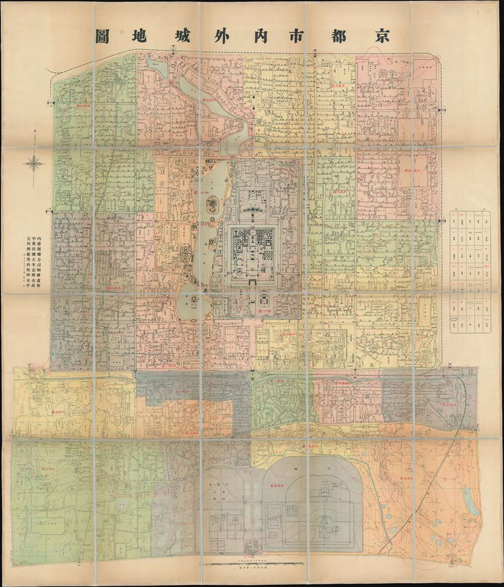
Capital City Inside and Out. / 京都市內外城地圖 / Jing dushi neiwaicheng ditu.
1916 (dated) 49.5 x 42.5 in (125.73 x 107.95 cm) 1 : 8000
1916 (dated) 49.5 x 42.5 in (125.73 x 107.95 cm) 1 : 8000
Description
This is an important ROC (Republic of China) 5 (民國五年), or 1916 map of Beijing, prepared by the municipal government for administrative purposes. This map, the first truly sophisticated Chinese map of Beijing, was the definitive city plan for roughly 20 years until it was superseded in 1936. The map covers the old walled center of Beijing, including the Imperial City, Forbidden City, Tartar City, and Chinese City.
Extremely scarce. Printings of this map were restricted to official internal use, and there was no commercial distribution, so its scarcity is understandable. We are aware of a few examples of this map in Chinese institutions, but there is no record of another example outside of China.
A Modern Chinese Map
This map was issued by the Republic of China shortly after the fall of the Beiyang Government and the death of the would-be emperor Yuan Shikai (袁世凱). The newly empowered ROC was eager to establish itself as a modern state, and part of that initiative involved resurveying China using modern cartographic methodologies, starting with its capital. This map was made using trigonometrical calculations based upon measured high elevations points throughout the city, thus reflecting the changes in Beijing's topographic elevations, administrative divisions, institutional settings, and traffic channels. It is the first fully Chinese map of Beijing to offer this level of cartographic sophistication.A Closer Look
There are more than 2,000 streets and alleys identified, as well as social halls, restaurants, theaters, post offices, telephones, telegraph offices, schools, etc. Topography is illustrated with a Western-style contouring system and red overprinting. Streets and avenues, as well as many hutong (traditional alleyway neighborhoods associated with siheyuan or traditional courtyard residences), are exactingly identified. Around this time, ROC reconstruction efforts began the long process of deconstructing the city's ancient defensive walls, most of which have vanished today, making this an exceptional record of 'Old Beijing' on the cusp of change.Publication History and Census
This map was prepared by the Municipal Office of Surveying and Mapping (市政公所測繪專科) and the Printing Bureau of the Ministry of Finance (財政部印刷局). It is dated using the Minguo (民國) or Republic of China calendar to Minguo 5 (民國五年), or 1916. This map remained the definitive administrative map of Beijing until superseded by the 1936/7 Surveyed Map of Inner City and Outer City, Beijing (實測北平市内外城地形).Extremely scarce. Printings of this map were restricted to official internal use, and there was no commercial distribution, so its scarcity is understandable. We are aware of a few examples of this map in Chinese institutions, but there is no record of another example outside of China.
Condition
Very good. Dissected and laid down on linen. Relined with fresh linen.