1874 Tardieu Map of Belgium, Holland (The Netherlands) and Luxembourg
BelgiqueHollande-tardieu-1874$75.00

Title
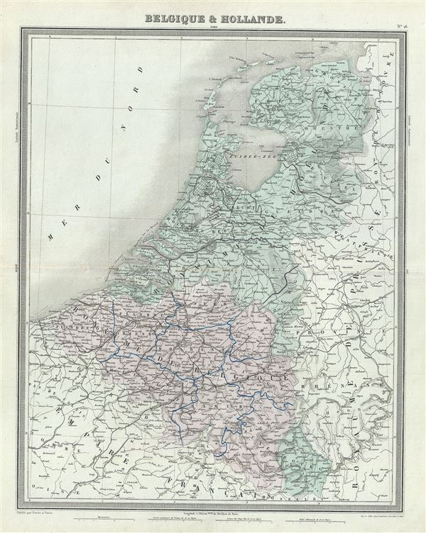
Belgique et Hollande.
1874 (undated) 18.5 x 14 in (46.99 x 35.56 cm) 1 : 1140000
1874 (undated) 18.5 x 14 in (46.99 x 35.56 cm) 1 : 1140000
Description
This is a fine 1874 map of Holland (The Netherlands), Belgium and Luxembourg by Ambroise Tardieu. It covers the United Kingdom of Netherlands including Holland and Belgium from the North Sea to the Duchy of Luxembourg. Various rivers, islands, mountain passes and other topographical features are noted.
In 1830, the Belgian Revolution led to the secession of Belgium from the United Kingdom of Netherlands and the creation of the independent Kingdom of Belgium. Though Belgium had successfully made itself independent, the Netherlands refused to recognize the new country until the 1839 Treaty of London.
This map was prepared by Ambroise Tardieu and issued as plate 16 in his 1874 edition of Atlas Universel de Geographie Ancienne et Moderne.
CartographerS
Ambroise Tardieu (March 2, 1788 - January 17, 1841) was a prominent French cartographer and engraver operating in the late 18th and early 19th centuries. He was member of the large and prolific Tardieu family, which, for over 200 years, produced multiple skilled and active engravers. Tardieu's work is known for its beauty and accuracy as well as for its depth of detail. Tardieu's most important work is his version of John Arrowsmith's large format map of the United States, published in 1806. Ambroise Tardieu is eclipsed in fame by his son, artist and medical scholar, August Ambroise Tardieu. Ambroise Tardieu is also frequently confused with Jean Baptiste Pierre Tardieu, another unrelated French map and print engraver active in the early 19th century. More by this mapmaker...
Alexandre Aimé Vuillemin (1812 - 1880) was an engraver, publisher, and editor based in Paris, France in the middle of the 19th century. Despite a prolific publishing career, much of Vuillemin's life is shrouded in mystery. In 1852, he married Josephine Caroline Goret and they had at least one child, Ernestine Adèle Vuillemin, later in the same year. What is known is that his studied under the prominent French Auguste Henri Dufour (1798 - 1865). Vuillemin's most important work his detailed, highly decorative large format Atlas Illustre de Geographie Commerciale et Industrielle. Learn More...
Source
Furne, Jouvet et Cie Atlas Universel de Geographie Ancienne et Moderne (Paris), 1874.
Condition
Very good. Minor wear along original centerfold. Original platemark visible. Minor spotting.
References
Rumsey 4697.020 (1863 edition).