This item has been sold, but you can get on the Waitlist to be notified if another example becomes available, or purchase a digital scan.
1930 Elizabeth Shurtleff Pictorial Map of Bermuda (Bermuda Islands)
BermudaIslands-shurtleff-1930$250.00


Title
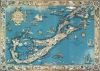
The Sommer Ilands. A map of the Bermuda Islands. Ya des Demonios, Isles of the Devils.
1930 (dated) 24.5 x 34.5 in (62.23 x 87.63 cm)
1930 (dated) 24.5 x 34.5 in (62.23 x 87.63 cm)
Description
A stunning large format pictorial map of Bermuda issued in 1930 by a trio of female mapmakers based in Boston: Elizabeth Shurtleff, Helen F. McMillin, and her niece Elizabeth L. McMillin. The map covers all of Bermuda including the adjacent islands. Pictorial vignettes illustrating island flora, fauna, and social life fill the island and the whole is surrounded by a coral reef motif border.
Women Pictorial Cartographers
Issued in 1930, this map appeared in the early days of the American pictorial map Golden Age. It was during this period, between 1920 and 1940, that women mapmakers began to rise to prominence. Among them Helen F. McMillin, Elizabeth L. McMillin, Alva Bennett Scott, and Ruth Taylor White, stand out as pioneers.20th Century Pictorial Cartography
Pictorial qualities have been common in cartography from at least from the 16th century, when publishers like Braun and Hogenberg incorporated view-like qualities and other pictorial elements into their famous city plans. Braun and Hogenberg, and similar cartographers, issued their town books to express, not necessarily the geography of their subjects, but rather the 'essence' of the town/city. As mathematics and surveying principles became more advanced, travel increased, and the ability to translate 2 dimensional cartographic perspectives into an understanding of the actual world became commonplace, maps themselves transformed. This trend is a recognizable progression that evolved cartographic conventions from the 17th to the 19th centuries. By the late 19th century most maps had become geographical tools that illustrated the region cartographically but failed in the original raison d'être as expressed by Braun and Hogenberg, to illustrate a place's 'essence'. So, where a city map of 19th century Paris might provide a completely navigable presentation of the city, one could glean almost nothing of Paris' character from it. In the late 18th century, the first modern 'pictorial' style maps developed. These maps, like Tomas Lopez's 1788 map of Seville, attempted to provide both cartographic accuracy and pictorial elements that might convey the character of the city. In that case, Lopez incorporated pictorial vignettes to illustrate important buildings and monuments. This style became increasingly common throughout the 19th century and early 20th centuries, particularly for centers of commerce like London, Paris, and Rome, where they are often mass produced and referred to as 'monumental' maps. The style further evolved in the early to mid-20th century, when revolutionary cartographers and illustrators like MacDonald Gill, Jo Mora, Frank Dorn, Ernest Dudley Chase, and many others, combined vignette style illustrations, modern printing techniques, inspiration from Japanese printmaking and manga, and from clever satirical cartographers/artists like Fred Rose, to produce maps that once again focused on revealing the essence a place, usually, but not always, at the sacrifice of cartographic precision.Publication History and Census
This map was designed and drawn by Elizabeth Shurtleff in 1930. The border is the work of Elizabeth L. McMillin. It was published jointly by Helen F. McMillin and Elizabeth Shurtleff and is one of the publications associated with their Boston based firm, Graphic History Association Publishers of Historical Maps. The printing was completed by Tudor Press of Boston. We note six examples in OCLC which are part of the collections at the Library of Congress, the Buffalo and Erie County Public Library, the University of Michigan, the University of Wisconsin Milwaukee, and Texas A and M University. Examples are also part of the Norman B. Leventhal Map Center at the Boston Public Library and the David Rumsey Map Collection.CartographerS
Elizabeth Shurtleff (September 3, 1890 - December 7, 1968), or Elizabeth Cate, was an American painter and artist active in the middle part of the 20th century. She was born in Concord, New Hampshire and attended the Boston Museum School of Fine Arts. Shurtleff is known for a small but significant corpus of pictorial maps issued alone and in collaboration with others between 1926 and 1930. She frequently collaborated with Wellesley graduates and pictorial mapmakers Helen F. McMillin, Elizabeth L. McMillin, and Alva Bennett Scott. These women were at the forefront of a new generation of female mapmakers emerging in the mid-20th century. Together with Helen F. McMillin, Shurtleff headed the Boston based Graphic History Association Publishers of Historical Maps. Elizabeth was married to Carroll L. Cate of Montreal. She died in Montreal in 1968. More by this mapmaker...
Helen Frances McMillin (June 9, 1896 - June 6, 1987) was and American publisher, writer, editor, and illustrator active in the middle part of the 20th century. McMillin was born to a prominent family of North Adams, Massachusetts and attended Wellesley College, where she was editor of the Wellesley Legenda and Wellesley College News. =After graduating in 1917, she moved to Boston, where she worked as publisher of the Granite Monthly. She remained in until at least 1926, but in 1930 she was living in New York City where she worked at the Museum of Modern Art. We have had a difficult time assessing out her marriage situation based upon announcements published in the North Adams Transcript. In 1921 there was an announcement of her engagement to Royal Stuart Steiner of Wisconsin, an economics professor. Another announcement appeared in 1930, to Richard G. Francois of New York. A third appears to suggest she married Royal Stewart Van de Woestyne (1892 - 1967), a Knox College economic professor, in 1933. Based upon ancestry research, it appears that Steiner and Van de Woestyne are one in the same, and so a name change may have occurred, for unclear reasons. She is the aunt of another important female pictorial map mapmaker and artist, Elisabeth L. McMillin (1909 - 19??). Together with Helen F. McMillin, Shurtleff headed the Boston based Graphic History Association Publishers of Historical Maps, which published several important pictorial maps between 1926 and 1936. Helen died in Hamilton, Ohio. Learn More...
Elizabeth L. McMillin (1909 - 19??) was and American publisher and illustrator active in the middle part of the 20th century. McMillan was born to a prominent family of North Adams, Massachusetts and attended Wellesley College. She frequently collaborated with Elizabeth Shurtleff, her aunt Helen F. McMillin, and fellow Wellesley Alum, Alva Bennett Scott. These women were at the forefront of a new generation of female mapmakers emerging in the mid-20th century. Learn More...
Tudor Press (fl. 1910 - 1967) was a Boston based lithograph, offset, and letterpress printer active in Boston throughout the 20th century. They were founded by Ralph Harland Wilbur (1875 - 19??). Wilber learnt the printing trade at the Melrose Journal, a job and book printing business. He struck out on his own, founding Tudor Press in 1910, with offices on Causeway Street, Boston. Ralphs children, Harland, Alvra, and Wesley joined the firm in the 1920s. The press acquired its first four-color offset press in 1940 and was active in printing maps for the war effort. Harland took over the firm in 1941. After World War II, the firm was contracted to issue military currency for U.S. Occupation forces. In 1967, it was relocated to Lawrence, Massachusetts and renamed Graphic Litho. Harland's son Ralph E. Wilbur, took over the firm in 1968. While the name Tudor Press is no longer used, Graphic Litho remains in business. Learn More...
Condition
Good. Backed with archival tissue. Some minor discoloration and a couple of repaired separations.
References
OCLC 20631819. Boston Public Library, Normon B. Leventhal Map Center 06_01_014646. Rumsey 7862.002.