
1937 Howard Newton City Map or Plan of Beverly Hills, California

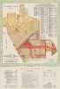
Map of Beverly Hills California.
Wealth and glamour in Beverly Hills.
$700.00
Choose a Collection:
- Digital Map Information
- Suitable for large format printing
- Full resolution TIFF file
- ICC color profile embedded
- Delivered instantly via download link
This Item
Enquire
Wealth and glamour in Beverly Hills.
This is a rare 1937 Howard W. Norton city map of Beverly Hills, California. This map emerged as the city was transforming from a modest community to a haven for Hollywood's Golden Age luminaries.A Closer Look
A dark brown line defines the limits of Beverly Hills. Streets throughout are labeled, including Sunset Boulevard, Santa Monica Boulevard, Wilshire Boulevard, and Rodeo Drive. Several schools, city parks, and playgrounds are named. City Hall, the post office, and the chamber of commerce are also labeled. City zoning, including a shopping zone, an apartment house zone, a residential zone, and an industrial zone, is codified. A key explaining the notations used is situated below the map in the lower left, adjacent to an index of public buildings, schools, and churches. A street index is included in the upper right.Historical Context
In the 1930s, Beverly Hills, California, transformed from a relatively modest community into a symbol of glamour and luxury, largely due to the burgeoning film industry in nearby Hollywood. This era saw an influx of movie stars and entertainment moguls, who built opulent estates designed by renowned architects. The city was defined by lavish homes, manicured gardens, and the famous Beverly Hills Hotel, a social hub for the elite. Rodeo Drive began its evolution into a high-end shopping district. Amidst the Great Depression, Beverly Hills stood as a stark contrast to much of the United States, embodying the extravagance of Hollywood's Golden Age.Publication History
This map was prepared by the Howard W. Newton Company and was published by the Beverly Hills Chamber of Commerce and the Beverly Hills Realty Board.Condition
Very good. Even overall toning. Light wear along original fold lines. Verso repair to fold separation.