This item has been sold, but you can get on the Waitlist to be notified if another example becomes available, or purchase a digital scan.
1652 Jansson Map of the Ancient Empire of Alexander the Great
AlexanderEmpire-jansson-1652$375.00

Title
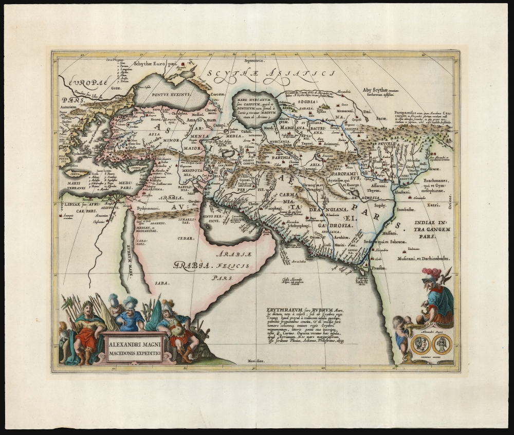
Alexandri Magni Macedonis Expeditio.
1652 (undated) 14.25 x 18.25 in (36.195 x 46.355 cm) 1 : 13700000
1652 (undated) 14.25 x 18.25 in (36.195 x 46.355 cm) 1 : 13700000
Description
This is Jan Jansson's 1652 map depicting the ancient empire of Alexander the Great of Macedonia. The map depicts Alexander's empire at its height, spanning from Greece to the Indus Valley. The map combines ancient toponymy with the geographical information known to the map's author, Abraham Ortelius. Jansson's map hews closely to Ortelius's composition while updating it aesthetically to suit its 17th-century audience.
As a student of Aristotle, and as the instrument of the spread of Hellenic culture, Alexander's life and conquests have been long-standing subjects of historical study: hence this map.
A Closer Look
The map's detail covers the Eastern Mediterranean, from Greece to Palestine, spanning from Elephantine on the Nile to the Black Sea and eastward to the Indus River from its mouth to its headwaters in the mountains of Afghanistan and Ladakh. While the geographical information is contemporary to the end of the 16th century, the place names are all drawn from Ortelius' classical sources, including Pliny, Plutarch, and Livy. The map is beautifully engraved and is decoratively rich. In the lower right is the verso and recto of a gold coin from Alexander's reign; both that illustration and the cartouche to the lower left are decorated with warriors in 15th- or 16th-century garb, intended to reflect antiquity.Alexander's Empire
Alexander, King of Ancient Macedonia, lived from 356 BC to 323 BC. His ruling years - from the age of 20 in 336 BC until his death - were spent in endless military campaigns expanding from Macedonia into western Asia and Egypt, building one of the largest empires in history. Ruined fortresses, the Arce Alexandri, mark the limits of the empire. These appear on the east bank of the Indus' tributary Hyphasis and north of the Black Sea.As a student of Aristotle, and as the instrument of the spread of Hellenic culture, Alexander's life and conquests have been long-standing subjects of historical study: hence this map.
Publication History and Census
This map was engraved for inclusion in Jansson's 1652 historical atlas, Accuratissima Orbis Antiqui Delineatio, which remained in print without recorded changes throughout the 17th century. The map plate was re-used in 1662 for Jansson's Atlas Novus. Examples appearing in that work exhibit text on the verso, absent here. The map appears on the market occasionally, and Jansson atlases are well-represented in institutional collections, but most catalogs neglect the separate map. It is listed in OCLC only by the Beinecke, the National Library of Wales, the Staats und Universitatsbibliothek Hamburg, and ULB Sachsen Anhalt Zentrale. The historical atlas itself is cataloged only three times in library collections.CartographerS
Jan Jansson or Johannes Janssonius (1588 - 1664) was born in Arnhem, Holland. He was the son of a printer and bookseller and in 1612 married into the cartographically prominent Hondius family. Following his marriage he moved to Amsterdam where he worked as a book publisher. It was not until 1616 that Jansson produced his first maps, most of which were heavily influenced by Blaeu. In the mid 1630s Jansson partnered with his brother-in-law, Henricus Hondius, to produce his important work, the eleven volume Atlas Major. About this time, Jansson's name also begins to appear on Hondius reissues of notable Mercator/Hondius atlases. Jansson's last major work was his issue of the 1646 full edition of Jansson's English Country Maps. Following Jansson's death in 1664 the company was taken over by Jansson's brother-in-law Johannes Waesberger. Waesberger adopted the name of Jansonius and published a new Atlas Contractus in two volumes with Jansson's other son-in-law Elizée Weyerstraet with the imprint 'Joannis Janssonii haeredes' in 1666. These maps also refer to the firm of Janssonius-Waesbergius. The name of Moses Pitt, an English map publisher, was added to the Janssonius-Waesbergius imprint for maps printed in England for use in Pitt's English Atlas. More by this mapmaker...
Abraham Ortelius (April 14, 1527 - June 28, 1598) also known as Ortels, was a cartographer, geographer, and cosmographer of Brabant, active in Antwerp. He was the creator of the first modern atlas, Theatrum Orbis Terrarum and is a seminal figure in the history of cartography. Along with Gerard Mercator and Gemma Frisius, he was a founder of the Netherlandish school of cartography. His connections with Spain - culminating in his 1575 appointment as Royal Cartographer to King Phillip II of Spain - gave him unmatched access to Spanish geographical knowledge during a crucial period of the Age of Discovery. Ortelius was born in 1527 in Antwerp. In 1547 he entered the Antwerp Guild of Saint Luke as an illuminator of maps. He began trading in books, prints, and maps, traveling regularly to the Frankfurt book and print fair, where in 1554 he met Mercator. He accompanied Mercator on journeys throughout France in 1560 and it was at this time, under Mercator's influence, that he appears to have chosen his career as a scientific geographer. His first published geographic work appeared in 1564, an eight-sheet cordiform world map. A handful of other maps preceded the 1570 publication of the first edition of the Theatrum Orbis Terrarum, which would prove to be his life work. Appearing with but 53 maps in its first edition, Ortelius' work expanded with new maps added regularly. By 1592, it had 134 maps. Many of Ortelius' maps remained the standard for nearly a century. He traveled extensively, but his genius was as a compiler, locating the best informed maps on which to base his own. His contacts throughout Europe and extending even (via the Portuguese) to the Far East were formidable. Moreover, many of his maps were based on his own scholarship, particularly his historical works. His theories of geography were particularly ahead of his time with respect to the notion of continental drift, the possibility of which he mused on as early as 1596, and which would be proven correct centuries later.
In a sense his greatest achievement was his successful navigation of the religious and political violence endemic to his city throughout his adult life: The Dutch Revolt, or Eighty Years' War (1568 - 1648), fully embroiled Antwerp. Although outwardly and officially recognized as Catholic (Arias Montanus vouched for Ortelius' Catholic orthodoxy prior to his appointment as Royal Geographer), Ortelius was able to separate himself from the religious furor which characterized the war in the low countries. Ortelius showed a glimpse of himself in a letter to a friend, regarding humanist Justus Lipsius: 'I do not know whether he is an adherent of the Pope or a Calvinist, but if he has ears to hear, he will neither be one nor the other, for sins are committed on both sides'. Ortelius' own explorations of Biblical history in his maps, and the Christogram contained in his own motto, suggest him to be a religious man, but his abjuration of political religious authorities mark him as an individualist. His tombstone at St Michael's Præmonstratensian Abbey in Antwerp bears the inscription, Quietis cultor sine lite, uxore, prole. ('served quietly, without accusation, wife, and offspring.') Learn More...
Source
Jansson, J., Accuratissima Orbis Antiqui Delineatio, (Amsterdam) 1652.
Condition
Excellent. Two tiny wormholes near centerfold not impacting printed image. Else a fine, full-margined example.
References
OCLC 253903898. Van der Krogt, P. C. J., Koeman's Atlantes Neerlandici, (Vol. 1) 8030:H:1.