This item has been sold, but you can get on the Waitlist to be notified if another example becomes available, or purchase a digital scan.
1874 J. S. Bird and Company City Plan or Map of Big Rapids, Michigan
BigRapidsMich-jsbirdco-1874$1,400.00

Title
Map of the City of Big Rapids, Mich.
1874 (dated) 52.5 x 40.75 in (133.35 x 103.505 cm) 1 : 3168
1874 (dated) 52.5 x 40.75 in (133.35 x 103.505 cm) 1 : 3168
Description
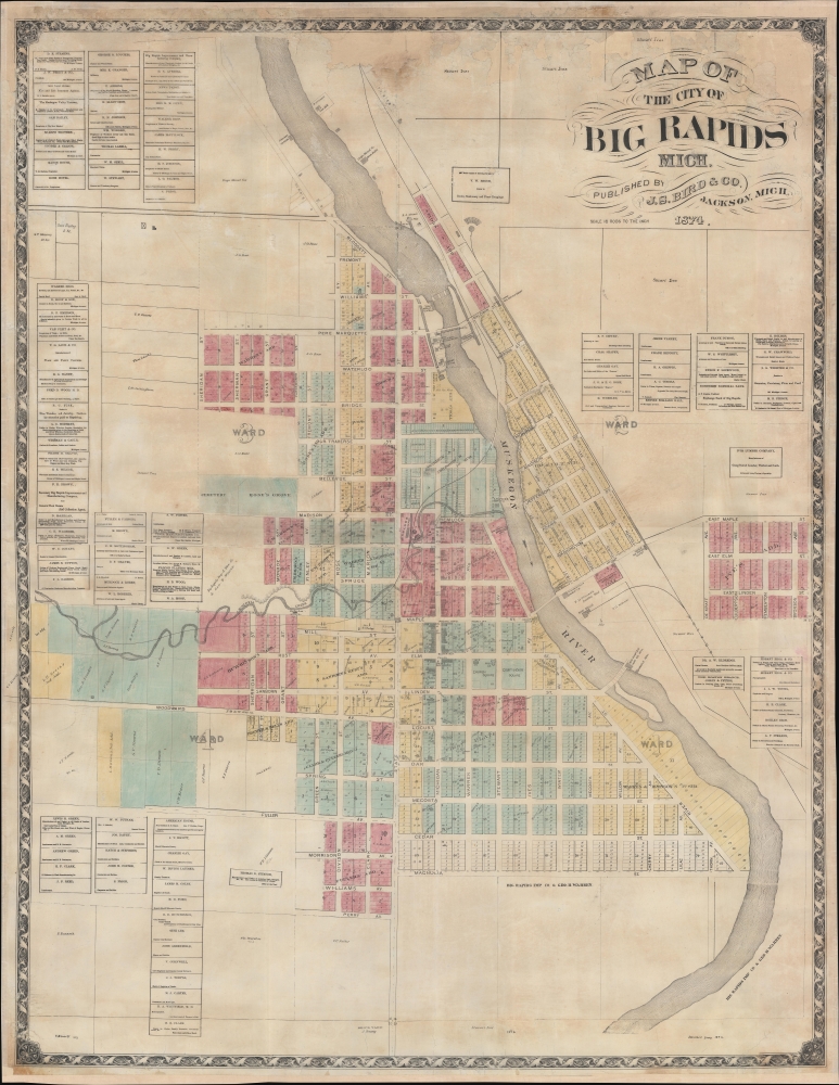
This is an 1874 J. S. Bird city map of Big Rapids, Michigan. It captures Big Rapids just 5 years after it was incorporated as a city, during the height of its explosive growth as a logging boomtown.
The lumber boom began in the late 1860s, when the city's population was about 1,200. During logging seasons, the city's population doubled, and lodgings were available to every lumberman that arrived. Logging was a big industry in Big Rapids and drove much of the city's economy, including its breweries. Four breweries were founded between 1868 and 1900, but only one lasted longer than ten years. Today, Big Rapids is home to Ferris State University, known for its College of Pharmacy and the Michigan College of Optometry.
A Closer Look
Built on both banks of the Muskegon River, most of Big Rapid's industry, including numerous sawmills, a shingle mill, a planing mill, and two tanneries, line the Muskegon's banks. The 'Grand Island and Indiana Railroad' runs along the right bank of the river while the 'Chicago and Michigan Lake Shore Railroad' runs through the city on the left bank. The city's street grid creates 16-lot city blocks. Buildings occupy some lots, many of which are identified with the owner's name. However, most lots are empty or owned by development corporations. Church Square and Courthouse Square are situated near the city center. The Walker Brothers Brewery is labeled along Mitchell Creek. Advertisements for local businesses appear along the left and right.Big Rapids, Michigan
Big Rapids is a city in central Michigan. The region became an important waypoint in the logging industry of the Lower Peninsula. Permanent settlement of Big Rapids began around 1855 when the first homes were built at a settlement known, at that point, as 'Leonard'. The name was officially changed to Big Rapids in 1859, the year the first official plat was recorded. Big Rapids was officially incorporated as a city in 1869, just five years before this map was publishedThe lumber boom began in the late 1860s, when the city's population was about 1,200. During logging seasons, the city's population doubled, and lodgings were available to every lumberman that arrived. Logging was a big industry in Big Rapids and drove much of the city's economy, including its breweries. Four breweries were founded between 1868 and 1900, but only one lasted longer than ten years. Today, Big Rapids is home to Ferris State University, known for its College of Pharmacy and the Michigan College of Optometry.
Publication History and Census
This map was created and published by J. S. Bird and Company in 1874. Rare. We note a single cataloged example which is part of the Archives of Michigan Map Collection.Cartographer
Judson Slatford Bird (October 9, 1846 - March 19, 1882) was an American civil engineer. Born on a farm outside Ann Arbor, Michigan, Bird attended the University of Michigan and graduated in 1870. After graduating, Bird published city maps under the imprint Taylor and Bird. In 1871 he was appointed City Engineer for Jackson, Michigan, and, by 1872, was operating the firm Bird, Mickle, and Waters on the side and publishing a map of 'one city per month'. In 1874 he was operating J. S. Bird and Company in Jackson, Michigan. By 1876 Bird had relocated to Blue Rapids, Kansas, where he was part of the Bird and Mickle Map Company with George W. Mickle. The firm published a large map of Marshall County, Kansas, in 1880, per his obituary. From newspaper articles we know that Bird and Mickle also published a map of Nemaha County, Nebraska; Davis County, Kansas; and Dickinson County, Kansas. They also published a plat book of Clay County, Kansas. However, another newspaper notice from 1878 stated that the Bird and Mickle Map Company had been 'adjudged bankrupts on their own petition'. Bird died on the evening of March 19, 1882, 'of cerebro-spinal affection' (likely meningitis). He married Mary Emily Sears (1838 - May 23, 1934) in 1873, with whom he had two children. More by this mapmaker...
Condition
Average. Professional restoration. Mounted on fresh linen. Areas of infill and reinstatement. Varnish residue.
References
Archives of Michigan Map Collection No. 1569 and No. 1570.