1720 Chatelain Chart of Noble Coats of Arms
BlazonNoblesse-chatelain-1720$450.00

Title
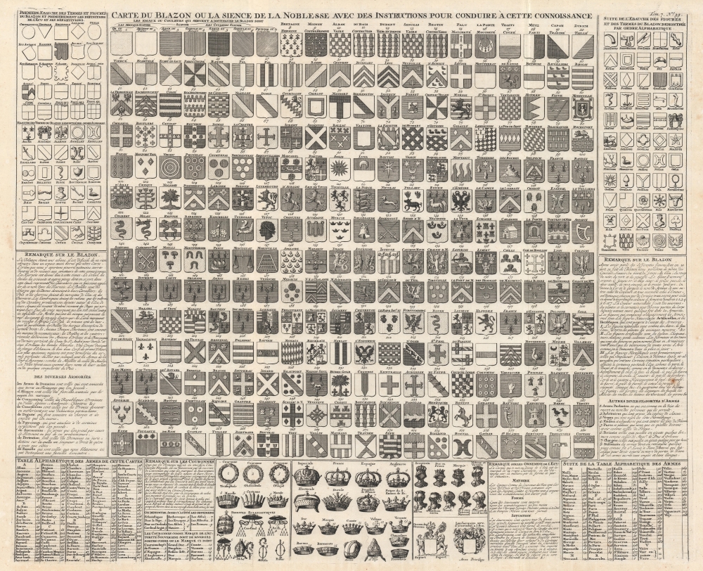
Carte du Blazon ou la Sience de la Noblesse avec des Instructions Pour Conduire à Cette Connoissance.
1720 (undated) 19.5 x 24 in (49.53 x 60.96 cm)
1720 (undated) 19.5 x 24 in (49.53 x 60.96 cm)
Description
This is a c. 1720 Henri Abraham Chatelain chart of European noble armorial crests. Over 200 coats of arms appear, alongside explanations of shield shapes and designs. Chatelain also describes crowns and helmets worn by the various nobles. An alphabetic table lists families or other entities meriting these armorial crests, each numerically identified.
Defining a Coat of Arms
Per Chatelain in the Suplément a l'Atlas Historique, a coat of armsis a mark of honor composed of certain colors and figures on insignia/badges, banners, or coats of arms to distinguish noble families; and given by Sovereigns as a reward for military exploits or some other considerable service rendered to the State. Thus it is important to know these colors and figures, which have taken the place of other markings that knights put on the coats of arms, on their helmets and shields, to make themselves known to their maidens during Tournaments, and to identify each other in battle. (Translated from the French in Chatelain's Suplément a l'Atlas Historique)
Publication History and Census
This chart was published by Henri Abraham Chatelain and François L'Honoré in 1720 in the seventh volume of their Atlas historique, ou Nouvelle introduction à l'histoire, à la chronologie et à la géographie ancienne et moderne... titled Suplément a l'Atlas Historique contenant diverses pièces de Chronologie, de Genealogie, d'Historie, et d'autres Science qui avoient été omises dans les précédens Volumes. The separate chart is not cataloged in OCLC. We note a single cataloged example of the separate chart, which in private hands. The Suplément a l'Atlas Historique is well represented in institutional collections.Cartographer
Henri Abraham Chatelain (1684 - 1743) was a Huguenot pastor of Parisian origins. He lived consecutively in Paris, St. Martins, London (c. 1710), The Hague (c. 1721) and Amsterdam (c. 1728). He is best known as a Dutch cartographer and more specifically for his cartographic contribution in the seminal seven volume Atlas Historique, published in Amsterdam between 1705 and 1720. Innovative for its time, the Atlas Historique combined fine engraving and artwork with scholarly studies of geography, history, ethnology, heraldry, and cosmography. Some scholarship suggests that the Atlas Historique was not exclusively compiled by Henri Chatelain, as is commonly believed, but rather was a family enterprise involving Henri, his father Zacharie and his brother, also Zacharie. More by this mapmaker...
Source
Chatelain, H., Suplément a l'Atlas Historique, (Paris) c. 1720.
Condition
Very good. Light wear along original fold lines.