This item has been sold, but you can get on the Waitlist to be notified if another example becomes available, or purchase a digital scan.
1901 Whitney Manuscript Map of the Back Bay Fens and Fenway - Kenmore, Boston, Mass.
BlockIndexPlanFens-whitney-1901$2,250.00

Title
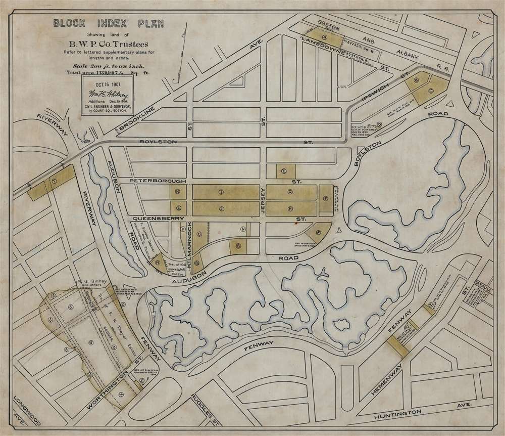
Block Index Plan Showing land of B.W.P. Co. Trustees.
1901 (dated) 18 x 21 in (45.72 x 53.34 cm) 1 : 2400
1901 (dated) 18 x 21 in (45.72 x 53.34 cm) 1 : 2400
Description
This is a 1901 William H. Whitney manuscript map of the Back Bay Fens and the Fenway - Kenmore neighborhood in Boston, Massachusetts. Coverage extends from Brookline Avenue to Huntington Avenue, but the Fens dominate the map, with the waterways emphasized in light blue. Land owned by the Boston Water Power Company is in toned yellow or green.
The Boston Water Power Company and the Back Bay Landfill Project
The Boston and Roxbury Mill Corporation was incorporated in 1824 to build a dam across the tidal marshlands of the Charles River - the intent being to harness the tides to power mills. The Boston Water Power Company was formed in 1824 to manage mill franchises and water rights. By the 1830s and 1840s, causeway railroads crisscrossed the basin, restricted water flow, and forced the mill project into insolvency. The Boston Water Power Company pivoted and presented a new plan to fill the Mill Basin entirely and sell off the land in lots. In 1856, the City of Boston, the Commonwealth of Massachusetts, and the Boston Water Power Company signed the Tripartite Indenture, which settled the plan for the development of the Back Bay. The Commonwealth finished filling the one hundred acres by 1866, with the Boston Water Power Company working into the 1880s to fill an even larger area. The Boston Water Power Company continued to own land in the Back Bay near the Fens until at least 1901 - when this map was issued. The lands were shortly thereafter lotted and sold off in private sales.The Back Bay Fens
The Back Bay Fens, also known as The Fens, is parkland and urban wild in Boston, Massachusetts. Frederick Law Olmsted (who designed New York's Central Park and Prospect Park) designed the Fens as part of Boston's Emerald Necklace. As Boston grew, the marshland to the west of the Shawmut Peninsula (where Boston was founded) became malodorous as sewage filled the tidal flat. To eliminate this problem and increase Boston's land area, a series of land reclamation projects eventually more than doubled the Shawmut Peninsula's land area. For Olmsted the project was two-fold: to restore the marsh to ecological health along with creating a recreation area to be enjoyed by Boston's citizens. He combined revolutionary sanitary engineering with his world-class landscaping to create the Fens.Publication History and Census
This is a unique manuscript records of early land holdings in Boston. The mapmaker, civil engineer William H. Whitney, was deeply involved in both the Fens and the Back Bay Landfill.Cartographer
William Henry Whitney (January 3, 1843 - May 4, 1909) was an American civil engineer active in Boston in the second half of the 19th century. Whitney was born in Needham, Massachusetts. He studied at Cambridge High School then at the Lawrence Scientific School of Harvard University. In July of 1862, he enlisted in the Union Army to fight in the American Civil War (1861 - 1865). He served honorably throughout the war, seeing action and suffering wounds twice. He left the service with the rank of Brevet-Major. He served as Alderman of Cambridge. and was involved with the Back Bay development project - producing multiple maps and plans. He began his studies as a civil engineer before the war in the office of Stephen P. Fuller. From 1869 - 1871 he worked in the Boston City Engineer's Office and was involved with the Back Bay development project - producing multiple maps and plans. In 1872, he entered into partnership with J. Franklin Fuller, son of S. P. Fuller. After a short time, Fuller retired and Whitney took full control of the firm, in 1888 renaming it William H. Whitney. As a private contractor he continued to work on the Back Bay. Also around this time, he completed multiple plans for the official records of the Civil War. Between 1889 and 1890, he took a contract with the Union Pacific to produce a series of maps of western cities, including Portland, Salt Lake City, Seattle, Astoria, Port Townsend, Spokane, and more. While he did not consider them an important part of his corpus, they are today arguably his most significant works, being among the earliest obtainable plans of those cities. He was also influential in introducing blueprint technology to American architecture and engineering. More by this mapmaker...
Condition
Very good. Manuscript map on waxed linen. Closed tear in lower margin just below Ruggles St. not effecting map.