1809 Dirección de Hidrografía Map of the Mouth of the Nassau River, Florida
BocaBarraRioNasau-hidrografia-1809$450.00

Title
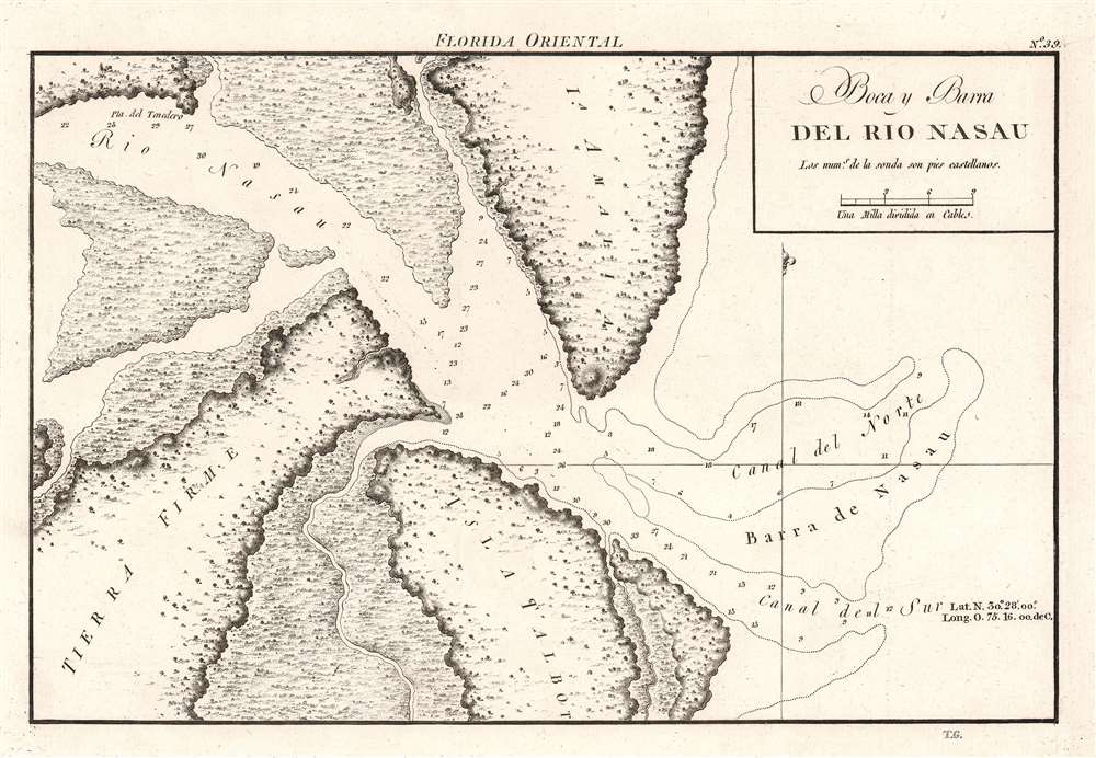
Boca y Barra del Rio Nasau.
1809 (undated) 7.25 x 10.75 in (18.415 x 27.305 cm) 1 : 55000
1809 (undated) 7.25 x 10.75 in (18.415 x 27.305 cm) 1 : 55000
Description
A rare find, this is the beautifully engraved 1809 Dirección de Hidrografía nautical chart or map of the mouth of the Nassau River, just to the south of Amelia Island. Florida. The river’s banks are depicted in as much detail as was likely available at the time, with only one point labeled, Pta. del Tenedero. Depth soundings populate both the northern and southern channels on either side of the Barra de Nasau.
Publication History and Census
This 1809 map was engraved by Tomás González and issued as plate thirty-seven in the Portulano de la America Setentrional, published by the Dirección de Hidrografía. We note a single cataloged example of the separate map, which is part of the collection of the Touchton Map Library at the Tampa Bay History Center. Nine examples of the complete atlas are cataloged in OCLC in collections worldwide.CartographerS
The Direccion Hidrografía (1787 - 1927), also known as the Deposito Hydrografico and the Direction de Hidrografía, was the Spanish equivalent of the British Admiralty or the U.S. Coast Survey. This organization, founded in 1787, was commissioned to collect and produce accurate nautical charts of all waters frequented by Spanish vessels. In essence, it replaced the Casa de la Contratación de las Indias (House of Trade of the Indies), which closed its doors in 1790. Like most such organizations, the Direccion Hidrografía marked a new age in cartography. Rather than simply collect charts created by navigators, explorers, and merchants, the Direccion Hidrografía worked closely with naval and military personnel to mount cartographic and hydrographic expeditions in pursuit of the most accurate hydrographical, astronomical, and geodetic measurements. The Direccion Hidrografía created a massive library of nautical charts that, though not nearly as common as similar nautical charts by the U.S. Coast Survey and British Admiralty, are highly desirable for the beauty of their manufacture as well as their accuracy and detail. The office was originally located on Calle Ballesta, but relocated to 36 Alcala, both in Madrid. After 1908 the Dirección was subsumed into other governmental agencies. In 1927 the Direccion was absorbed into the Institute and Observatory of San Fernando, located in Cadiz. The library of original maps, charts, and journals was transferred to the Naval Museum of Madrid - where it resides to this day. More by this mapmaker...
Tomás González (fl. c. 1809 - c. 1832) was a Spanish engraver active with the Dirección de Hidrografía in the early 19th century. Very few references appear to González appear in the historical record. It appears he was sent to Paris in 1802 to learn lithographic printing. Learn More...
Source
Direccion Hidrografia, Portulano de la America Setentrional (Madrid: Direccion de trabajos hidrograficos) 1809.
Portulano de la America Setentrional, was one of the last great works of the Spanish Admiralty focusing on North America. It is a rare atlas with maps detailing Spanish harbors in Central America, North America, and the Caribbean. Work on the atlas began in 1792 when Admiral Jose de Mazaredo y Salazar and Vincente Tofiño dispatched two scientific mapping expedition to the Americas with the goal of creating Spanish charts for use by the Spanish Navy. Until 1787, the Spanish government had jealously guarded its geographical and hydrographical knowledge, to the point of restricting map publication, but King Charles III lifted this prohibition as part of this Enlightenment reforms. The dispatched expeditions completed their work by 1805 but had sent manuscript charts back to Cadiz on a regular basis. The Dirección de Hidrografía published the Portulano de la America Setentrional in 1809 and its consisted of 121 charts divided into four sections: Puertos de las Islas Antillas (fourteen plates); Puertos de las Costas de Tierra- Firme, Florida y Seno Megicano (thirty-six plates); Puertos de la Isla de Cuba (thirty-four plates); and Puertos de las Islas de Santo Domingo y Jamayca (twenty-two plates). Published during the Peninsular War between Spain, Portugal, and the United Kingdom against the invading and occupying First French Empire (1807 - 1814), very few examples were printed. In many ways it's extraordinary that any examples were printed at all. The unfortunate reality is that this magnificent piece of scientific hydrography had never gained the recognition it deserves. The Dirección de Hidrografía reissued the atlas in 1818, which is nearly identical to the 1809 edition except for the addition of the phrase 'Aumentado y corre-gido en 1818' to the title page. An completely reengraved edition was published in Mexico City in 1825.
Condition
Very good.
References
Tampa Bay History Center L2018.111.047.