
1908 Garcia Meza Folding Map of Bolivia

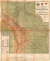
Mapa general de la Republica de Bolivia.
Bolivia's Border Disputes.
- Digital Map Information
- Suitable for large format printing
- Full resolution TIFF file
- ICC color profile embedded
- Delivered instantly via download link
Bolivia's Border Disputes.
This is a 1908 Luis Garcia Meza chromolithographic folding map of Bolivia. It was produced amid Bolivia's tense border disputes with Peru and Brazil, which in the latter case had resulted in a war only several years prior.A Closer Look
Bolivia - along with portions of Peru, Brazil, Paraguay, Argentina, and Chile - is displayed in rich color and detail. International boundaries as well as the borders of departamentos and provincias are traced. Cities and towns, religious missions, roads, railways (existing, under construction, and planned, including the impressive Ferrocarril de Antofagasta a Bolivia / Antofagasta and Bolivia Railway), post and telegraph offices, historical battlefields, and other features are marked throughout, according to the legend below the title. Color-shading and relief is used to reflect the dramatic changes in elevation and landscape across the country, which is also reflected in the profile at bottom and the curious graphic at bottom left showing the 'vertical distribution' of flora and fauna. Another illustration demonstrates the relative length of rivers in Bolivia.Bumptiousness and Border Disputes
This map was prepared as Bolivia was in the process of settling decades-long border disputes with Peru and Brazil that resulted from the vagueness of Spanish colonial provinces and failed 19th-century efforts at larger unions of South American territories. Initially, such unsettled borders could be overlooked, given the remoteness of much of the territory, but they became increasingly relevant in the late 19th century when the commercialization of natural resources - especially gold and rubber - made them a potential source of wealth.This map reflects Bolivia's territorial claims in Acre at top-left, despite Bolivia having lost much of this territory to Brazil in the Acre War (1899 - 1903), formalized in the Treaty of Petrópolis. The conflict originated when the rubber boom drew thousands of Brazilian migrants into the Acre region, a remote, forested territory that legally belonged to Bolivia under earlier treaties. By the 1890s, Brazilians vastly outnumbered Bolivians in the region, and tensions escalated as settlers resisted Bolivian authority, leading to several short-lived separatist revolts supported by local rubber tappers. Bolivia's attempt to assert control by leasing Acre to a foreign syndicate in 1899 provoked further unrest, culminating in the Acre War, during which Brazilian irregulars defeated Bolivian forces. The Treaty of Petrópolis in 1903 ceded Acre to Brazil in exchange for monetary compensation, land in Mato Grosso, and a promise to construct a Madeira-Mamoré railway (which was never completed), represented at top here to the left of the title, securing Brazil's claim over this crucial rubber-producing region.
Bolivia's border dispute with Peru was slightly less volatile but originated from similar issues. After independence in the early 19th century, both republics claimed overlapping territories, especially in the Madre de Dios and Purús river basins, which were poorly mapped and sparsely settled. Tensions rose in the mid-19th century as each country sought to expand its influence into the Amazon, leading to diplomatic friction and occasional armed incidents. The dispute was partially settled by the 1909 Treaty of Polo-Bustamante, followed by the 1909 Treaty of Rectification and a 1929 agreement, which clarified much of the border. However, lingering disagreements persisted until a 1992 treaty between Peru and Bolivia confirmed the current boundary and granted Bolivia a free-trade zone in Peru's port of Ilo to ease its lack of sovereign seacoast.
Chromolithography
Chromolithography, sometimes called oleography, is a color lithographic technique developed in the mid-19th century. The process involved using multiple lithographic stones, one for each color, to yield a rich composite effect. Oftentimes, the process would start with a black basecoat upon which subsequent colors were layered. Some chromolithographs used 30 or more separate lithographic stones to achieve the desired product. Chromolithograph color could also be effectively blended for even more dramatic results. The process became extremely popular in the late 19th and early 20th centuries when it emerged as the dominant method of color printing. The vivid color chromolithography produced made it exceptionally effective for advertising and propaganda imagery.Publication History and Census
This map was prepared by Luis Garcia Meza (not to be confused with the later Bolivian dictator of the same name) in 1908 and published in Switzerland by Kartographia Winterthur. The Swiss printer Winterthur was likely chosen because Bolivia did not have a significant printing infrastructure (Many other significant maps of Bolivia and other South American countries were also published in either the United States or Europe), and because Kartographia Winterthur would have been well-practiced in depicting mountainous terrain in relief. Despite being listed as an 'ex-ingeniero del Estado' among other titles, nothing is known of Garcia Meza aside from this map. The present map is also curiously noted as being the 7th edition, but all surviving examples of this map are also of the 7th edition, with no known earlier edition or state surviving. The map is listed in six separate catalog listings in the OCLC, but cumulatively is only noted among the holdings of nine institutions, mostly in Europe.Cartographer
Kartographia Winterthur (1842 - 1924) was a Swiss map publisher based in Winterthur, in the canton of Zurich. It was founded in 1842 by Johann Ulrich Wurster (1814 - 1880) and was known as Joh. Wurster and Comp., changing its name frequently as partners joined and left the company or died, before finally settling on Kartographia Winterthur A.-G. in 1906. The company is best known for publishing the Schweizer Weltatlas in 1910, and for its detailed, brilliantly-colored maps of mountainous regions, publishing the work of master mountain cartographers like Rudolf Leuzinger (1826 - 1896). Nevertheless, in 1924, the company went bankrupt and was acquired by Orell-Füssli-Verlag. Further Details...
Condition
Average. Laid down on original linen, accompanied by original binder. Some wear on old fold lines, including slight loss at a fold intersection in the Pacific. Area of recto damage due to old tape repair in the Gran Chaco region, lower right quadrant.
References
OCLC 795773260, 55290685.