This item has been sold, but you can get on the Waitlist to be notified if another example becomes available, or purchase a digital scan.
1892 Rand McNally Map of Bolivia, Ecuador and Peru
BoliviaEcuador-randmcnally-1895$37.50

Title
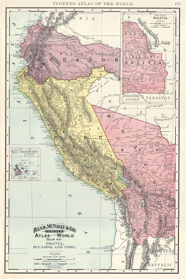
Map of Bolivia, Ecuador, and Peru.
1892 (dated) 20 x 13 in (50.8 x 33.02 cm) 1 : 6700000
1892 (dated) 20 x 13 in (50.8 x 33.02 cm) 1 : 6700000
Description
This is a beautiful example of Rand McNally and Company's 1892 map of Bolivia, Ecuador and Peru. It covers from Esmeraldas in Ecuador to Potosi in Bolivia. An inset in the top right quadrant features the eastern portion of Bolivia and another inset near the left margin features the Galapagos Islands. This map dates to a period after the War of the Pacific, in which Bolivia fought against Chile and eventually lost territory, including its access to the sea, and the port of Antofagasta. In the subsequent years, it also lost the State of Acre to Brazil. Several Indian tribes are identified throughout. Color coded according to countries, the map notes several towns, cities, rivers, mountains, lakes and various other topographical details with relief shown by hachure. This map was issued as plate no. 417 in the 1893 issue of Rand McNally and Company's Indexed Atlas of the World - possibly the finest atlas Rand McNally ever issued.
Cartographer
Rand, McNally and Co. (fl. 1856 - present) is an American publisher of maps, atlases and globes. The company was founded in 1856 when William H. Rand, a native of Quincy, Massachusetts, opened a print shop in Chicago. Rand hired the recent Irish immigrant Andrew McNally to assist in the shop giving him a wage of 9 USD per week. The duo landed several important contracts, including the Tribune's (later renamed the Chicago Tribune) printing operation. In 1872, Rand McNally produced its first map, a railroad guide, using a new cost effective printing technique known as wax process engraving. As Chicago developed as a railway hub, the Rand firm, now incorporated as Rand McNally, began producing a wide array of railroad maps and guides. Over time, the firm expanded into atlases, globes, educational material, and general literature. By embracing the wax engraving process, Rand McNally was able to dominate the map and atlas market, pushing more traditional American lithographic publishers like Colton, Johnson, and Mitchell out of business. Eventually Rand McNally opened an annex office in New York City headed by Caleb S. Hammond, whose name is today synonymous with maps and atlases, and who later started his own map company, C. S. Hammond & Co. Both firms remain in business. More by this mapmaker...
Source
Rand McNally and Co., Rand, McNally & Co's Indexed Atlas of the World, (Chicago) 1893.
Condition
Very good. Text on verso.
References
Rumsey 3565.047 (1897 edition). Philip (atlases) 1026 (1898 edition).