1949 Jones Literary Pictorial Map of the United States
BookloversMap-jones-1949$800.00

Title
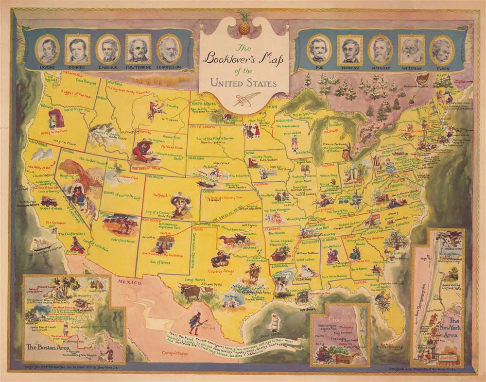
The Booklover's Map of the United States.
1949 (dated) 20.5 x 26.25 in (52.07 x 66.675 cm) 1 : 7900000
1949 (dated) 20.5 x 26.25 in (52.07 x 66.675 cm) 1 : 7900000
Description
This is a 1949 Amy Jones pictorial literary map of the United States. Book titles appear across the country, with at least one in each state, including Gone with the Wind, Walden, My Ántonia, and Main Street. Authors are also referenced throughout, such as William Faulkner, Ernest Hemingway, Emily Dickinson, and Robert Frost. Pictorial vignettes are scattered throughout as well, illustrating scenes and characters from many of the referenced works. Three insets are situated along the bottom border and focus on the 'New York Area', the 'Chicago Area', and the 'Boston Area'. Portraits of ten authors flank the title cartouche and include depictions of Irving, Longfellow, Poe, and Twain.
20th Century Pictorial Cartography
Pictorial qualities have been common in cartography from at least from the 16th century, when publishers like Braun and Hogenberg incorporated view-like qualities and other pictorial elements into their famous city plans. Braun and Hogenberg, and similar cartographers, issued their town books to express, not necessarily the geography of their subjects, but rather the 'essence' of the town/city. As mathematics and surveying principles became more advanced, travel increased, and the ability to translate 2 dimensional cartographic perspectives into an understanding of the actual world became commonplace, maps themselves transformed. This trend is a recognizable progression that evolved cartographic conventions from the 17th to the 19th centuries. By the late 19th century most maps had become geographical tools that illustrated the region cartographically but failed in the original raison d'être as expressed by Braun and Hogenberg, to illustrate a place's 'essence'. So, where a city map of 19th century Paris might provide a completely navigable presentation of the city, one could glean almost nothing of Paris' character from it. In the late 18th century, the first modern 'pictorial' style maps developed. These maps, like Tomas Lopez's 1788 map of Seville, attempted to provide both cartographic accuracy and pictorial elements that might convey the character of the city. In that case, Lopez incorporated pictorial vignettes to illustrate important buildings and monuments. This style became increasingly common throughout the 19th century and early 20th centuries, particularly for centers of commerce like London, Paris, and Rome, where they are often mass produced and referred to as 'monumental' maps. The style further evolved in the early to mid-20th century, when revolutionary cartographers and illustrators like MacDonald Gill, Jo Mora, Frank Dorn, Ernest Dudley Chase, and many others, combined vignette style illustrations, modern printing techniques, inspiration from Japanese printmaking and manga, and from clever satirical cartographers/artists like Fred Rose, to produce maps that once again focused on revealing the essence a place, usually, but not always, at the sacrifice of cartographic precision.Publication History and Census
This map was designed and illustrated by Amy Jones and published by the R. R. Bowker Company in 1949. We note ten cataloged examples in OCLC which are part of the collections at the Library of Congress, the Carnegie Library of Pittsburgh, the Université Laval, the South Carolina State Library, the University of Illinois at Urbana Champaign, Southern Illinois University, the University of Florida, Oklahoma State University, the University of Arizona, and the University of Washington. It is rare on the private market.Cartographer
Amy Jones (April 4, 1899 - October 8, 1992) was an American artist and muralist. Born in Buffalo, New York, as Amy A. White, her father died early in her life and by 1910 she and her mother were living in Brooklyn, New York. Jones attended Erasmus Hall High School and graduated in 1918 and then attended the Pratt Institute on scholarship and studied art. Jones spent two years at Pratt before going to the Albright Art Gallery in Buffalo, New York. Between 1920 and 1930, Jones studied with Cecil Chichester in Woodstock, New York; Henry Hensche in Provincetown, Massachusetts; Wayman Adams in Elizabethtown, New York; and Anthony di Bona in Saranac Lake, New York. The Buffalo Society of Arts awarded Jones a fellowship in 1930, and she and her husband moved to Saranac Lake, where her husband was a tubercular patient in a nursing home. Jones was awarded her first commission in 1937 after submitting a triptych for one of the Treasury Department's mural competitions. This contract was for the post office mural in Winsted, New York, which she completed in 1938. Then, she earned a second commission for a mural for the post office in Painted Post, New York, in 1939. A third post office mural, this time in Scotia, New York, was completed in 1941. She and her husband left Saranac Lake in 1943 and moved to Mount Kisco, New York, where she lived for nearly forty years. Over the course of her career, Jones exhibited work throughout the United States and Europe and many of per paintings are part of institutional and private collections. In addition to being a talented watercolorist and muralist, Jones also succeeded as a commercial artist and illustrator. Jones married her first husband, David Blair Jones, in 1920, and he passed away in 1955. Then, she married Owen Phelps Frisbie in 1961 and he died on June 12, 1963. Jones continued working throughout the 1970s and 1980s, with exhibitions of her work shown in Venice and Padua, Italy; Kingston, Jamaica; and several galleries and museums in New York. She moved to Escondido, California, in 1986 to be closer to her daughter. More by this mapmaker...
Condition
Very good.
References
OCLC 29316326.