This item has been sold, but you can get on the Waitlist to be notified if another example becomes available, or purchase a digital scan.
1913 Rand McNally Map of New York City (Manhattan, Bronx, Brooklyn, Queens) w/ Jersey City
BoroughManhattan-mcnally-1913$100.00

Title
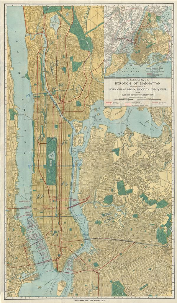
The Rand McNally Map of the Borough of Manhattan the principal portions of the Boroughs of Bronx, Brooklyn and Queens and the Business District of Jersey City.
1913 (dated) 35 x 20 in (88.9 x 50.8 cm) 1 : 29000
1913 (dated) 35 x 20 in (88.9 x 50.8 cm) 1 : 29000
Description
This is a fine 1913 map of New York City by Rand McNally and Company. The map covers the entirety of New York City, including the boroughs of Manhattan, Brooklyn, the Bronx, Queens and part of Hoboken and Jersey City, New Jersey. It includes Roosevelt Island, Governor's Island, Ellis Island, Rikers Island (along with 'extension being filled in'), Wards Island and Randall Island. A large inset in the top right quadrant features Greater New York. Fort Washington is identified. The map further identifies various canals, individual streets and avenues, bridges, parks, reservoirs, train lines, ferry lines and important buildings. This map was copyrighted 1913 and published by Rand McNally and Company, New York.
Cartographer
Rand, McNally and Co. (fl. 1856 - present) is an American publisher of maps, atlases and globes. The company was founded in 1856 when William H. Rand, a native of Quincy, Massachusetts, opened a print shop in Chicago. Rand hired the recent Irish immigrant Andrew McNally to assist in the shop giving him a wage of 9 USD per week. The duo landed several important contracts, including the Tribune's (later renamed the Chicago Tribune) printing operation. In 1872, Rand McNally produced its first map, a railroad guide, using a new cost effective printing technique known as wax process engraving. As Chicago developed as a railway hub, the Rand firm, now incorporated as Rand McNally, began producing a wide array of railroad maps and guides. Over time, the firm expanded into atlases, globes, educational material, and general literature. By embracing the wax engraving process, Rand McNally was able to dominate the map and atlas market, pushing more traditional American lithographic publishers like Colton, Johnson, and Mitchell out of business. Eventually Rand McNally opened an annex office in New York City headed by Caleb S. Hammond, whose name is today synonymous with maps and atlases, and who later started his own map company, C. S. Hammond & Co. Both firms remain in business. More by this mapmaker...
Condition
Very good. Minor wear along original fold lines. Blue markings at places. Professionally flattened and backed with archival tissue. Accompanied by original binder.
References
OCLC number: 18591342. Stanford University Libraries, G3804 .N4:2 M3 1913 .R33.