This item has been sold, but you can get on the Waitlist to be notified if another example becomes available, or purchase a digital scan.
1759 Lotter Map of Northern Poland
BorussiaePoland-lotter-1759$325.00

Title
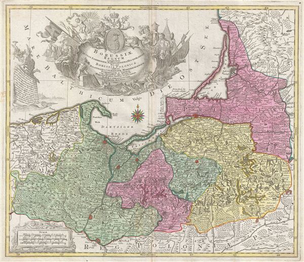
Borussiae Regnum Complectens Circulos Sambiensem, Natangiensem et Hockerlandiae nec non Borussia Polonica Exhibens Palatinatus Culmiensem, Marienburgensem, Pomerelliae et Varmiae.
1759 (dated) 20 x 23 in (50.8 x 58.42 cm)
1759 (dated) 20 x 23 in (50.8 x 58.42 cm)
Description
A stunning 1759 first edition, first state, map of northern Poland (Borussiae) by the Augsburg cartographer Tobias Conrad Lotter. The map covers from German Pomerania eastward to Lithuania and Belarus and from the Baltic Sea to Torun (Thorn). Includes the major cities of Gdansk (Dantzig), elblag (elbing), Malbork (Marienburg), Lidzbark Warminski (Hielsberg), Koningsberg (modern day Russia), and Chelmno (Culm). Mountains and forests are rendered in profile following the Lotter typical stylistic conventions. An elaborate decorative cartouche bearing numerous allegorical elements fills the Baltic Sea, top center. During the 18th century this area was consolidated into Brandenberg-Prussia by Frederick the Great but were returned to a reconstituted Poland by the Treaty of Versailles following World War II. The presence of the date, 1759, at the base of the title cartouche identifies this as the first edition first state of this map. It was engraved by Tobias Conrad Lotter and printed in Augsburg, Germany.
Cartographer
Tobias Conrad Lotter (1717 - 1777) was a German engraver and map publisher. Lotter was the son of a baker and city guardsman, but married Euphrosina (1709 - 1784) Seutter, elder daughter of the prominent map publisher Matthäus Seutter. He began working at his is father-in-law's map business about 1740. Between 1740 and 1744 he produced, under Seutter's imprint, the Atlas minor, Praecipua orbis terrarum imperia, regna et provincias, Germania potissimum tabelli. Upon Seutter's death, in 1757, the firm's stock was taken over by his son, Albrecht Karl Seutter (1722 - 1762), who himself died in 1762, just a few years later. The remaining Seutter map plates were subsequently divided between Lotter and the publisher Johan Mitchell Probst (1727 - 1776). With the support of his sons, Matthäus Albrecht (1741 - 1810), Georg Friedrich (1744 - 1801) and Gustav Conrad (1746-1776), Tobias Conrad Lotter succeeded in building on the economic success and professional reputation of his father-in-law. In time, Lotter became one of the most prominent mid-18th century map publishers working in the German school. After Lotter's death in 1777, the business was taken over by his two eldest sons, who, lacking their father's business acumen, presided over the firm's slow decline. It was nonetheless passed on to a subsequent generation of Lotters, Matthäus Albrecht Lotter's sons, Gabriel (1776 - 1857) and Georg Friedrich (1787 - 1864), who pushed it into further decline until it faded out in the early-19th century. More by this mapmaker...
Condition
Very good. Original centerfold. Platemark visible. Blank on verso.