This item has been sold, but you can get on the Waitlist to be notified if another example becomes available, or purchase a digital scan.
1784 Bocage Map of The Bosphorus and the City of Byzantium / Istanbul / Constantinople
Bosphorus-white-1793$85.00

Title
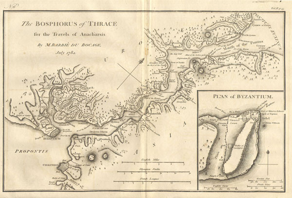
Bosphorus and the city of Byzantium.
1784 8.5 x 12 in (21.59 x 30.48 cm)
1784 8.5 x 12 in (21.59 x 30.48 cm)
Description
This lovely map, depicting the Bosphorus and the city of Byzantium, was prepared by M. Barbie de Bocage in 1784 for the 'Travels of Anarcharsis.' The map shows the narrow naval passage from the Propontis (Sea of Marmara) to the Pontus Euxinus (Black Sea). There is a beautiful inset plan of the Horn of Byzantium. Today Byzantium is Istanbul, but the horn and many of the ancient structures still exists. This map also shows the area in considerable topographical detail.
Cartographer
Jean Denis Barbie du Bocage (1760 - 1825) and his son Jean-Guillaume Barbie du Bocage (1795 - 1848) were French cartographers and cosmographers active in Paris during late 18th and early 19th centuries. The elder Barbie du Bocage, Jean Denis, was trained as a cartographer and engraver in the workshops of mapmaking legend J. B. B. d'Anville. At some point Jean Denis held the post of Royal Librarian of France and it was through is associations with d'Anville that the d'Anville collection of nearly 9000 maps was acquired by French Ministry of Foreign Affairs. The younger Barbie du Bocage, Jean-Guillaume, acquired a position shortly afterwards at the Ministry of Foreign Affairs and, in time, became its head, with the title of Geographe du Ministere des Affaires Etrangeres. More by this mapmaker...
Condition
Fine or Perfect condition.