This item has been sold, but you can get on the Waitlist to be notified if another example becomes available, or purchase a digital scan.
1938 Ernest Dudley Chase Pictorial Map of Boston and Vicinity
Boston-chase-1938$400.00

Title
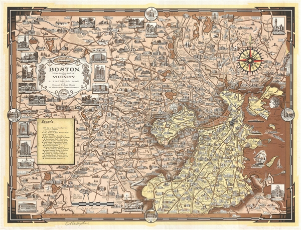
Boston (Massachusetts) and Vicinity. A Pictorial Map.
1938 (dated) 18.5 x 24.5 in (46.99 x 62.23 cm) 1 : 55500
1938 (dated) 18.5 x 24.5 in (46.99 x 62.23 cm) 1 : 55500
Description
A fine example of Ernest Dudley Chase's 1938 extraordinarily detailed whimsical pictorial map of Boston and its vicinity. The map is roughly centered on Watertown and covers from Wayland to Boston Harbor and from Stoneham to Hyde Park. It features 20 large vignette views of important and historic buildings, as well as countless smaller illustrations throughout. Special larger vingettes are worked into the border and include the Boston Public Library, the Parker House, the Copley-Plaza Hotel and the Paul Revere House. It illustrates the route of Paul Revere's ride, as well as civic buildings, commercial centers, piers, shipping lanes, roads, railroads, and geographical features.
B Like many chase maps, it is signed in the lower left quadrant. All and all, a fine example of Chase's distinctive style. This map was issued in both colored and uncolored variants. This is the more desirable colored version.
B
Cartographer
Ernest Dudley Chase (July 26, 1878 - August 25, 1966) was an American illustrator of greeting cards and pictorial maps active in the first half of the 20th century. From his studio in Winchester, Massachusetts, Chase became famous for his elaborately illustrated pictorial maps. He was born in Lowell, Massachusetts, and attended the Lowell Textile School and the Vesper George Art School. He took work with Butterfield Printing Company in 1900. In 1906, he moved to the W. T. Sheehan Printing Firm. He began producing postcards and greeting cards on his own account in 1908. This initial imprint was Des Arts Publishers, but later, he changed it to Ernest Dudley Chase Publishers. Chase is best known today for his distinctive pictorial maps, most of which he published privately, characterized by dense vignette images of important locations. The biographical pamphlet A Meticulous Maker of Maps describes Chase's attention to detail wherein, pursuing a 'passion for perfection' by stippling his images 'dot-by-dot, with tiny pens' under a magnifying glass. His impressive corpus includes nearly 50 maps focusing on various parts of the United States and Europe, as well as other international locations and novelty pieces. Most are thematic, focusing on topics such as wonders of the world, stamps, aviation, and war. Others, such as his map of The United States as viewed by California and Loveland are satirical. All, in their original editions, are coveted by a dedicated following of modern collectors. More by this mapmaker...
Condition
Very good. Extremely minor professionally repaired margin tear lower right. Does not affect printed image.
References
Rumsey 6793.000. OCLC 11199394.