1828 Milbert View of Boston, Massachusetts
Boston-milbert-1828$1,200.00

Title
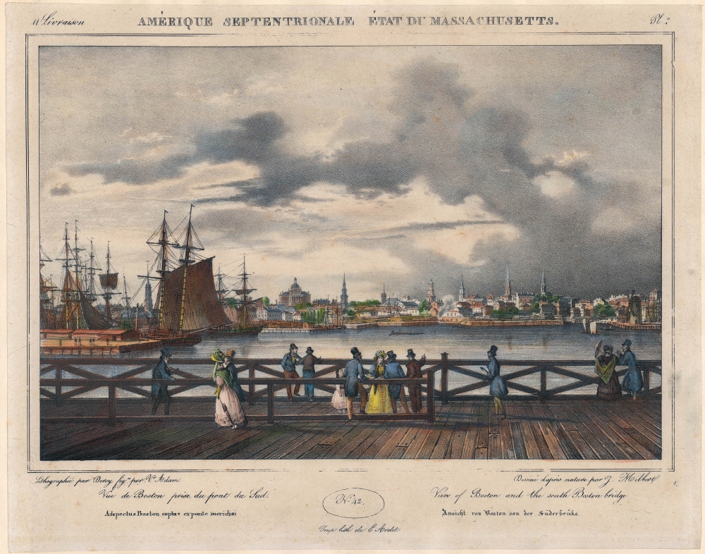
Pl. 2 / No. 42 / Amérique Septentrionale Etat de Massachusetts / Vue du Boston prise du pont du Sud / View of Boston and the South Boston Bridge / Adspectus Boston captus exponte meridiei / Ansicht von Boston von der Südbrücke.
1828 (undated) 10 x 13 in (25.4 x 33.02 cm)
1828 (undated) 10 x 13 in (25.4 x 33.02 cm)
Description
A charming 1828 view of Boston, Massachusetts by Jacques-Gérard Milbert. It displays the city as it was quickly transforming, including through the addition of new land by filling in parts of Boston Harbor.
The Massachusetts State House is prominent in the distance at center-left, with its original grey-painted copper dome. (It was later gilded with gold leaf, giving it the brilliant luster that it maintains today.) Also dominating the skyline are the steeples of several churches, including the Park Street Church, Old West Church, and Old South Meeting House. Large ships sit docked at left, while several smaller ones ply the waters of the harbor toward right. In the foreground, pedestrians amble along the toll bridge, which, despite its steep cost, afforded a nice panoramic view of the city.
This view, drawn by Milbert between 1815 and 1823, depicts Boston as its physical landscape was changing rapidly. In the early 19th century, Beacon Hill was reduced to create landfill that expanded the area of the city, most notably in South Boston and the Back Bay, to accommodate its growing population. Boston was also devastated by a catastrophic fire in 1794, with many of its existing structures being damaged or destroyed.
A Closer Look
Oriented towards the northwest, this view looks out over the water that once separated South Boston from Boston. The bridge in the foreground, mentioned in the title, was a toll bridge built by land developers who had overseen landfill near the Dorchester Neck. This work became part of South Boston, using land shaved off of Beacon Hill (the water was later mostly filled in and now sits just to the south of South Station, lying beneath Interstate-93 and rail lines leading into South Station). The toll bridge was seen as too expensive and the city built a free bridge to South Boston soon afterwards, causing the investors to eventually sell their privately-operated bridge at a loss.The Massachusetts State House is prominent in the distance at center-left, with its original grey-painted copper dome. (It was later gilded with gold leaf, giving it the brilliant luster that it maintains today.) Also dominating the skyline are the steeples of several churches, including the Park Street Church, Old West Church, and Old South Meeting House. Large ships sit docked at left, while several smaller ones ply the waters of the harbor toward right. In the foreground, pedestrians amble along the toll bridge, which, despite its steep cost, afforded a nice panoramic view of the city.
This view, drawn by Milbert between 1815 and 1823, depicts Boston as its physical landscape was changing rapidly. In the early 19th century, Beacon Hill was reduced to create landfill that expanded the area of the city, most notably in South Boston and the Back Bay, to accommodate its growing population. Boston was also devastated by a catastrophic fire in 1794, with many of its existing structures being damaged or destroyed.
Publication History and Census
This view was drawn by Jacques G. Milbert and lithographed by Victor Adam as Plate 2 in Milbert's Itineraire pittoresque du fleuve Hudson et parties laterales de l'Amérique du Nord, published by Henri Gaugain et Cie in Paris in 1828. It is independently cataloged among the holdings of the Boston Athenaeum, the State Library of Massachusetts, the New York Public Library, and the National Maritime Museum in Greenwich, while the entire Itineraire pittoresque is more widely distributed. This example differs from other known examples in that it is hand-colored and noted at bottom as being printed by E. Ardit (in addition to Adam).CartographerS
Jacques-Gérard Milbert (November 18, 1766 - June 5, 1840) was a French artist and naturalist. He trained under Pierre-Henri de Valenciennes and taught drawing at the École nationale supérieure des mines de Paris. Afterwards, he embarked on a series of voyages that took him to different corners of the world. He joined Nicolas Baudin's voyage to Australia in 1800 as one of the expedition's appointed artists, but fell out with the captain and left the expedition before it reached its destination. Nevertheless, he published Voyage pittoresque à l'Ile de France, au Cap de Bonne Espérence et à l'Ile de Ténériffe on his return to France. Afterwards, in 1815, he moved to the United States of America, where he would live for eight years. Based in New York City, Milbert travelled extensively throughout New England and Upstate New York, producing drawings and collecting natural history specimens that were sent back to the Muséum national d'histoire naturelle in Paris. He returned to France in 1823 to teach again at the mining school and published his accounts and drawings of the United States. More by this mapmaker...
Jean Victor Adam (January 28, 1801 - December, 30 1866), often simply as Victor Adam, was a French painter and printer (lithographer). Born and raised in Paris, his father Jean Adam was an engraver. Jean Victor studied at the École des Beaux-Arts and worked with the noted painters Charles Meynier and Jean-Baptiste Regnault. After 1819, he was commissioned to paint a series of works celebrating French victories in the recent wars of the revolutionary and Napoleonic eras. Although his works spanned many subjects, he remained best known for his battle scenes. From 1846, he devoted himself to the production of lithographs rather than paintings. Learn More...
Condition
Very good. Remnants of adhesive from earlier matting along top edge. Uneven toning and some handwriting along bottom edge.
References
OCLC 57745950.