
This item below is out of stock, but another example (left) is available. To view the available item, click "Details."
Details
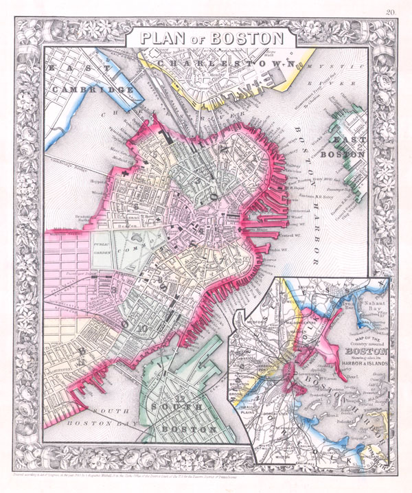
1862 Mitchell City Plan or Map of Boston, Massachusetts
1862 (dated) $300.00
1864 Mitchell Map of Boston, Massachusetts
Boston-mitchell-1864$100.00

Title
Plan of Boston.
1860 (dated) 11 x 9.5 in (27.94 x 24.13 cm)
1860 (dated) 11 x 9.5 in (27.94 x 24.13 cm)
Description
A beautiful example of S. A. Mitchell Jr.'s 1864 map of Boston, Massachusetts. Depicts Boston along with parts of East Cambridge, Charlestown, East Boston, and South Boston. Offers wonderful detail at the street level including references to parks, individual streets, trains, piers, ferries, and important buildings. Colored coded with pastels according to city wards. An inset in the lower right quadrant depicts Boston Harbor and the greater Boston area. Surrounded by the attractive floral border common to Mitchell atlases between 1860 and 1865. This variant differs from earlier examples (1860-2) of Mitchell's Boston only in coloration. One of the more attractive atlas maps of Boston to appear in the mid 19th century. Prepared by S. A. Mitchell Jr. for inclusion as plate 20 in the 1864 issue of Mitchell's New General Atlas. Dated and copyrighted, 'Entered according to Act of Congress in the Year 1860 by S. Augustus Mitchell Jr. in the Clerk's Office of the District Court of the U.S. for the Eastern District of Pennsylvania.'
Cartographer
Samuel Augustus Mitchell (March 20, 1792 - December 20, 1868) began his map publishing career in the early 1830s. Mitchell was born in Bristol, Connecticut. He relocated to Philadelphia in 1821. Having worked as a school teacher and a geographical writer, Mitchell was frustrated with the low quality and inaccuracy of school texts of the period. His first maps were an attempt to rectify this problem. In the next 20 years Mitchell would become the most prominent American map publisher of the mid-19th century. Mitchell worked with prominent engravers J. H. Young, H. S. Tanner, and H. N. Burroughs before attaining the full copyright on his maps in 1847. In 1849 Mitchell either partnered with or sold his plates to Thomas, Cowperthwait and Company who continued to publish the Mitchell's Universal Atlas. By about 1856 most of the Mitchell plates and copyrights were acquired by Charles Desilver who continued to publish the maps, many with modified borders and color schemes, until Mitchell's son, Samuel Augustus Mitchell Junior, entered the picture. In 1859, S.A. Mitchell Jr. purchased most of the plates back from Desilver and introduced his own floral motif border. From 1860 on, he published his own editions of the New General Atlas. The younger Mitchell became as prominent as his father, publishing maps and atlases until 1887, when most of the copyrights were again sold and the Mitchell firm closed its doors for the final time. More by this mapmaker...
Source
Mitchell's New General Atlas, containing Maps of the Various Countries of the World, Plans of Cities, Etc., Embraced in Fifty-three Quarto Maps, forming a series of Eighty-Four Map and Plans, together with Valuable Statistical Tables. (1864 Edition)
Condition
Very good condition. Wide clean margins. Blank on verso.
References
Rumsey 0565.011. Phillips (Atlases) 831-16.